LOS ANGELES RIVER WATERSHED
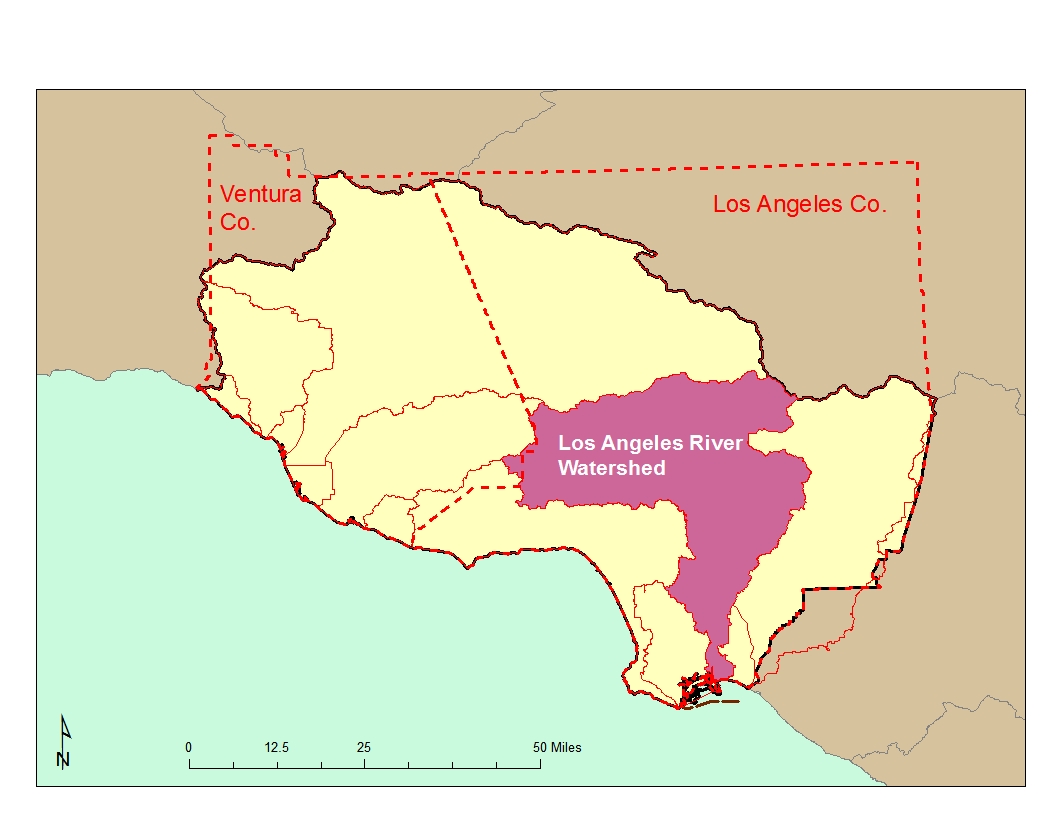
The Los Angeles (LA) River Watershed is one of the largest in the Region at 824 square miles; the river is 55 miles long. It is also one of the most diverse in terms of land use patterns. Approximately 324 square miles of the watershed are covered by forest or open space land including the area near the headwaters which originate in the Santa Monica, Santa Susana, and San Gabriel Mountains. The rest of the watershed is highly developed.
 Major tributaries to the river in the San Fernando Valley are the Pacoima Wash, Tujunga Wash (both drain portions of the Angeles National Forest in the San Gabriel Mountains), Burbank Western Channel and Verdugo Wash (both drain the Verdugo Mountains). Due to major flood events at the beginning of the century, by the 1950's most of the river was lined with concrete. In the San Fernando Valley, there is a section of the river with a soft bottom at the Sepulveda Flood Control Basin. The Basin is a 2,150-acre open space upstream of the Sepulveda Dam designed to collect flood waters during major storms. Because the area is periodically inundated, it remains in a semi-natural condition and supports a variety of low-intensity uses as well as supplying habitat. At the eastern end of the San Fernando Valley, the river bends around the Hollywood Hills and flows through Griffith and Elysian Parks, in an area known as the Glendale Narrows. Since the water table was too high to allow laying of concrete, the river in this area has a rocky, unlined bottom with concrete-lined or rip-rap sides. This stretch of the river is fed by natural springs and supports stands of willows, sycamores, and cottonwoods. The many trails and paths along the river in this area are heavily used by the public for hiking, horseback riding, and bird watching.
South of the Glendale Narrows, the river is contained in a concrete-lined channel down to Willow Street in Long Beach. The main tributaries to the river in this stretch are the Arroyo Seco (which drains areas of Pasadena and portions of the Angeles National Forest in the San Gabriel Mountains), the Rio Hondo, and Compton Creek. Compton Creek supports a wetland habitat just before its confluence with the Los Angeles River. The river is hydraulically connected to the San Gabriel River Watershed by the Rio Hondo through the Whittier Narrows Reservoir. Flows from the San Gabriel River and Rio Hondo merge at this reservoir during larger flood events, thus flows from the San Gabriel River Watershed may
impact the LA River. Most of the water in the Rio Hondo is used for groundwater recharge during dry weather seasons. The San Gabriel River drains approximately 689 square miles, which includes the eastern San Gabriel Mountains and portions of the Chino, San Jose, and Puente Hills.The LA River tidal prism/estuary begins in Long Beach at Willow Street and runs approximately three miles before joining with Queensway Bay located between the Port of Long Beach and the city of Long Beach. The channel has a soft bottom in this reach with concrete-lined sides. Queensway Bay is heavily water recreation-oriented; however, major pollutant inputs are likely more related to flows from the LA River which carries the largest storm flow of any river in southern California.
Also part of the watershed is a number of lakes including Peck Road Park, Belvedere Park, Hollenbeck Park, Lincoln Park, and Echo Park Lakes as well as Lake Calabasas. These lakes are heavily used for recreational purposes.
 Four basins in the San Fernando Valley area contain substantial deep groundwater reserves and are recharged mainly through runoff and infiltration although the increase in impermeable surfaces has decreased infiltration. Groundwater basins in the San Gabriel Valley are not separated into distinct aquifers other than near the Whittier Narrows. Active recharge occurs in some of these areas through facilities operated by Los Angeles County. Spreading grounds recharge two basins in the coastal plain of Los Angeles west of the downtown area.
The river flows through the San Fernando Valley past heavily developed residential and commercial areas. From the Arroyo Seco, north of downtown Los Angeles, to the confluence with the Rio Hondo, the river flows through industrial and commercial areas and is bordered by rail yards, freeways, and major commercial and government buildings. From the Rio Hondo to the Pacific Ocean, the river flows through industrial, residential, and commercial areas, including major refineries and petroleum products storage facilities, major freeways, rail lines, and rail yards serving the Ports of Los Angeles and Long Beach.
 Water Quality Problems and Issues
Pollutants from dense clusters of residential, industrial and other urban activities have impaired water quality in the middle and lower watershed. Added to this complex mixture of pollutant sources (in particular, pollutants associated with urban and stormwater runoff), is the high number of point source permits. Excessive nutrients (and their effects) and coliform are widespread problems in the watershed as well as excessive metals. Water column toxicity was found at a number of sites sampled by SWAMP in 2005. A considerable amount of water quality data are available on the California Environmental Data Exchange Network at http://www.ceden.org and on the My Water Quality web portal at http://www.mywaterquality.ca.gov/index.shtml.
The locations of facilities with discharges to surface water or to the ground (other than those covered by general industrial or construction stormwater permits) are shown in the following figure. Click here to obtain a complete list of permitted discharges.
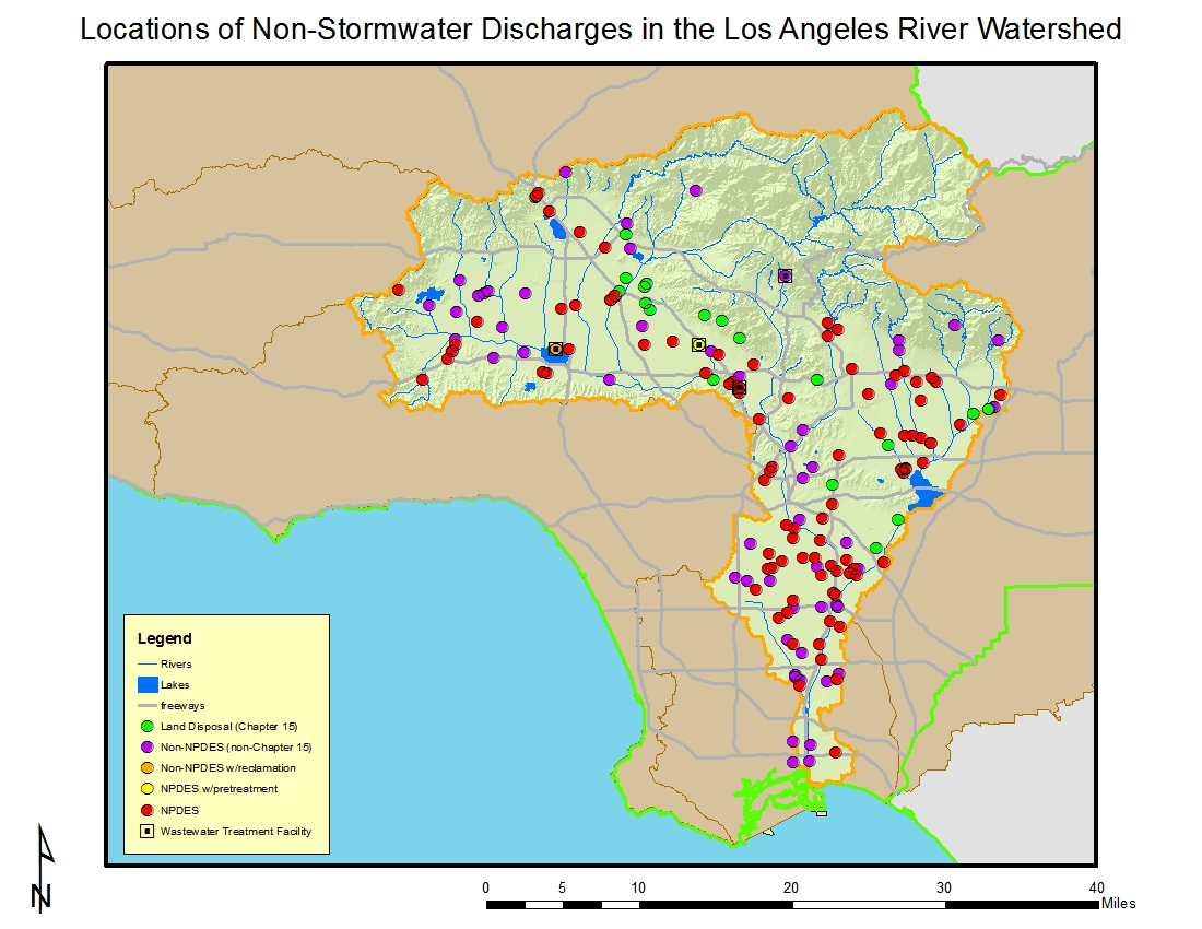
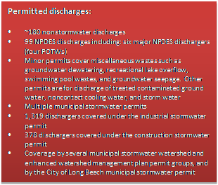
A majority of the approximately 100 NPDES discharges go directly to the Los Angeles River.
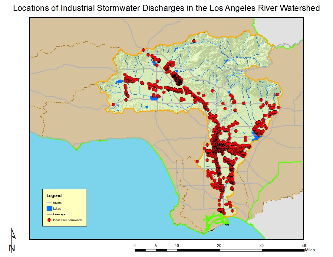
Of the 1,319 dischargers enrolled under the general industrial storm water permit in the watershed, the largest numbers occur in the cities of Los Angeles (many within the community of Sun Valley), Vernon, South Gate, Long Beach, Compton, and Commerce. Wholesale trade-durable goods, fabricated metal products, trucking & warehousing, and chemicals & allied products are a large component of these businesses based on their Standard Industrial Classification (SIC) codes. This watershed has about twice the number of industrial stormwater dischargers as does the San Gabriel River Watershed and the most in this region. The locations of facilities with discharges covered by the general industrial stormwater permit are shown in the following figure.
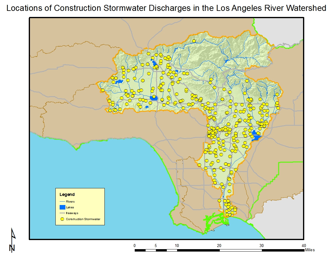
There are a total of 378 construction sites enrolled under the general construction storm water permit in this watershed (shown below), the most in the Region but half of the number of sites enrolled in 2007. The larger sites are in the upper watershed (which includes the San Fernando Valley) and the construction in this watershed is fairly evenly divided between commercial and residential. About one-third of the sites are five acres or larger in size with the largest sites being up to 700 acres.
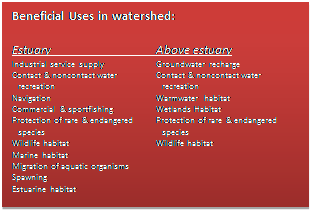
The majority of the LA River Watershed outside of National Forest land is considered impaired due to a variety of point and nonpoint sources. The 2010 303(d) list implicates pH, ammonia, a number of metals, coliform, trash, scum, algae, oil, chlorpyrifos as well as other pesticides, and volatile organics. Some of these constituents are of concern throughout the length of the river while others are of concern only in certain reaches. Impairment may be due to water column exceedances, excessive sediment levels of pollutants, or bioaccumulation of pollutants. The beneficial uses threatened or impaired by degraded water quality are aquatic life, recreation, groundwater recharge, and municipal water supply. Click on the link to obtain a complete list of impairments.
Ground water resources in the watershed are also impacted. Impacts, both real and threatened, include those from hundreds of cases of known leaking underground storage tanks that have contaminated soil and/or ground water with petroleum hydrocarbons and volatile organic compounds. There are also a number of cases of refineries/tank farms that have contaminated soil and/or ground water. Seawater intrusion is of concern in other areas of the watershed which has necessitated wellhead treatment, shutdown, or blending. Finally, a number of wells have been shut down due to nitrate contamination with septic systems as a likely source. 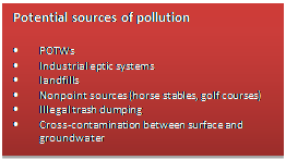 The major issues of concern in the watershed include: 1) protection and enhancement of fish and wildlife habitat, 2) removal of exotic vegetation, 3) enhancement of recreational areas, 4) attaining a balance between water reclamation and minimum flows to support habitat, 5) management of storm water quality, 6) assessment of other nonpoint sources including horse stables, golf courses, and septic systems, 7) pollution from contaminated ground water, 8) groundwater recharge with reclaimed water, 9) contamination of ground water by volatile organic compounds, 10) leakage of MTBE from underground storage tanks, 11) groundwater contamination with heavy metals, particularly hexavalent chromium, and 12) contaminated sediments within the LA River estuary.
Regional Board Actions to Address Impairments
A number of Regional Board programs and actions are in place to address the water quality impairments noted earlier.
Total Maximum Daily Loads (TMDLs) have been developed (as required by the Clean Water Act) for many of the impairments in the watershed. The TMDL is a number that represents the assimilative capacity of a receiving water to absorb a pollutant and is the sum of the individual wasteload allocations for point sources, load allocations for nonpoint sources plus an allotment for natural background loading, and a margin of safety. TMDLs can be expressed in terms of mass per time (the traditional approach) or in other ways such as toxicity or a percentage reduction or other appropriate measure relating to a water quality objective. A TMDL is implemented by reallocating the total allowable pollution among the different pollutant sources (through the permitting process or other regulatory means) to ensure that the water quality objectives are achieved. TMDLs in effect in all or parts of the watershed include those for nutrients, bacteria, metals, and trash. The lakes within the watershed are covered by a TMDL established by USEPA. Additional information on these TMDLs may be found at http://www.waterboards.ca.gov/losangeles/water_issues/programs/tmdl/. The municipal discharges of storm water and non-storm water by the Los Angeles County Flood Control District, the County of Los Angeles, and 84 incorporated cities within the coastal watersheds of Los Angeles County with the exception of the City of Long Beach (hereinafter referred to separately as Permittees and jointly as the Dischargers) from all Municipal Storm Sewer Systems (MS4 – commonly known as the storm drain system) within Los Angeles County with the exception of Long Beach are subject to waste discharge requirements which were adopted in 2012. Both storm water and non-storm water from the MS4 is subject to the permit requirements. The permit effectively prohibits non-storm discharges into the MS4 and receiving waters with certain exceptions. It also requires that treatment control BMPs be designed to meet certain performance criteria, that each Permittee implement programs and measures to comply with the TMDLs’ waste load allocations for the MS4 specified in the permit, and that regular inspections of various types of commercial facilities be undertaken. A monitoring program must also be implemented. Certain provisions of the permit are organized by watershed management area, which is appropriate given the requirements to implement 33 watershed-based TMDLs.
The MS4 Permittees are allowed the flexibility to develop Watershed Management Programs to implement requirements in the permit on a watershed scale through customized strategies, control measures, and BMPs. Participation in a Watershed Management Program is voluntary and allows a
Permittee to address the highest watershed priorities. Customized strategies, control measures, and BMPs shall be implemented on a watershed basis, where applicable, through each Permittee’s storm water
management program and/or collectively by all participating Permittees through a Watershed Management Program (WMP). Permittees may elect to develop an enhanced Watershed Management
Program (EWMP). An EWMP is one that comprehensively evaluates opportunities, within the participating Permittees’ collective jurisdictional area in a Watershed Management Area, for collaboration among Permittees and other partners on multi-benefit regional projects that, wherever feasible, retain all
non-storm water runoff and all storm water runoff from the 85th percentile, 24-hour storm event for the drainage areas tributary to the projects, while also achieving other benefits including flood control and water supply, among others. Permittees have formed several EWMP groups within the Los Angeles River Watershed which include the Upper Los Angeles River Watershed Group, the Los Angeles River Upper Reach 2 Subwatershed, the Lower Los Angeles River Watershed, and the Rio Hondo/San Gabriel River Water Quality Group. Several other permittees are developing individual WMPs including: Compton, El Monte, Irwindale, San Fernando, and South El Monte. More information about this permit may be found at http://www.waterboards.ca.gov/losangeles/water_issues/programs/stormwater/municipal/index.shtml#los_angeles.
Municipal storm water and urban runoff discharges from the MS4 owned and operated by the City of Long Beach are covered by separate waste discharge requirements. More information about this permit may be found at http://www.waterboards.ca.gov/losangeles/water_issues/programs/stormwater/municipal/index.shtml#long_beach.
A number of TMDLs contain load allocations assigned to irrigated agriculture. The Regional Board adopted a conditional waiver for discharges from irrigated lands (see http://www.waterboards.ca.gov/losangeles/water_issues/programs/tmdl/waivers/index.shtml) which requires agricultural interests to monitor and implement various best management practices as needed to improve the quality of runoff from irrigated lands. This can be accomplished by growers either individually or through joining a group effort; within Los Angeles County, growers are organized into the Nursery Growers Association Los Angeles County Irrigated Lands Group.(NGA).
The regulatory and permitting issues surrounding the dredging and disposal of often contaminated sediments in boating areas is complex. Regional Board staff participates on an interagency team called the Southern California Dredged Material Management Team (SC-DMMT) which was established for the coordinated review of dredging projects and dredging policy issues within the Southern California area, including Los Angeles and Ventura Counties. In Los Angeles County, selected dredging projects are reviewed through the Los Angeles Regional Contaminated Sediment Task Force (CSTF) which was established through legislation in 1997 and with which Regional Board staff also participates. The CSTF developed a long-term management plan for dredging and disposal of contaminated sediments in the Los Angeles area. The CSTF also formulated guidelines for an Advisory Committee to conduct a coordinated project review of dredging activities in the Los Angeles region. Currently, the CSTF Advisory Committee evaluates proposed dredging and disposal projects, including pre-application planning, and evaluation of sampling results.
Activities Led by Watershed Stakeholders
Stakeholders within the area under the jurisdiction of the Los Angeles Regional Board have formed several long-range water planning groups and have developed Integrated Regional Water Management (IRWM) Plans under Propositions 50 and 84. These Plans address the future water needs of each IRWM Region in terms of reliability of the water supply, improvement to water quality (including implementing TMDLs), increases in habitat and open space (additionally serving as areas for recharge of stormwater), and replacement of water-related infrastructure as needed. They also propose projects to help implement the Plan’s goals; applicants may pursue funding through a variety of sources including grant funding available through bond programs.
Stakeholders in a large portion of Los Angeles County joined together to develop the Integrated Regional Water Management (IRWM) Plan for Greater Los Angeles County (GLAC). Parts of two subregions of the GLAC fall within the Los Angeles River Watershed. The website for the group is http://www.lawaterplan.org. Within the southeastern portion of Los Angeles County, generally overlying the Central Groundwater Basin, another IRWM Region was formed, the Los Angeles Gateway IRWM Region. Part of the Region falls within the Los Angeles River Watershed. Their website is http://www.gatewayirwmp.org.
The Los Angeles Basin Stormwater Conservation Study is being undertaken by the Los Angeles County Department of Public Works and the U.S. Department of the Interior, Bureau of Reclamation. The purpose of this proposed Basin Study is to identify alternatives, conduct trade-off analyses and develop recommendations to help bridge the gap between current and future water supply and water demand in the Basin Study watersheds (Los Angeles River, San Gabriel River, Ballona Creek, Dominguez Channel/Los Angeles Harbor, North Santa Monica Bay, South Santa Monica Bay, and Malibu Creek), taking into account climate change and population growth projections. The Basin Study will analyze imbalances in supply and demand by conducting a literature review of all water inputs and outputs. The Basin Study will identify issues where changes to the operation of water supply systems, modifications to existing facilities, development of new facilities, or non-structural changes by the Los Angeles County Flood Control District and its partners could help address water supply needs.
The US Army Corps of Engineers developed a draft Los Angeles River Ecosystem Restoration Integrated Feasibility Report that evaluates alternatives for the purpose of restoring 11 miles of the Los Angeles River from approximately Griffith Park to downtown Los Angeles while maintaining existing levels of flood risk management. Restoration measures considered include creation and reestablishment of historic riparian strand and freshwater marsh habitat to support increased populations of wildlife and enhance habitat connectivity within the study area, as well as to provide opportunities for connectivity to ecological zones such as the Santa Monica Mountains, Verdugo Hills, Elysian Hills, and San Gabriel Mountains. Restoration also includes the reintroduction of ecological and physical processes such as a more natural hydrologic and hydraulic regime that reconnects the river to historic floodplains and tributaries, reduces flow velocities, increases infiltration, improves natural sediment processes, and improves water quality. Further information can be found at http://www.spl.usace.army.mil/Media/PublicNotices/tabid/1320/Article/17994/spl-2013-003-nlh-draft-ifr-for-la-river-eco-rest-study.aspx.
The City of Los Angeles, US Army Corps of Engineers and multiple partners developed a Los Angeles River Revitalization Master Plan which is available for download at http://www.lariver.org. The Plan provides a framework for restoring the River’s ecological function and includes recommendations for physical improvements, policy level recommendations for managing public access, recommendations for a River governance and management structure, and recommendations for short- and long-term priority projects and potential funding strategies.
The Los Angeles River Watershed Monitoring Program (LARWMP) was developed by the Cities of Burbank and Los Angeles in cooperation with the Regional Board and USEPA staff, as well as other local stakeholders. The POTWs in the watershed participate in the implementation of the LARWMP as described in their permits’ monitoring and reporting program. The goals of the comprehensive watershed-wide monitoring program include evaluating or assessing: compliance with receiving water objectives, trends in surface water quality, impacts to beneficial uses, the health of the biological
community, data needs for modeling contaminants of concern, and attaining the goals of the TMDLs under implementation in the Los Angeles River. The Council for Watershed Health serves as the coordinator for the monitoring and also reports on the results at http://www.watershedhealth.org/programsandprojects/larwmp.aspx.
The Council for Watershed Health used Proposition 13 grant funds from the State Water Resources Control Board to prepare a Compton Creek Watershed Management Plan. Compton Creek is a tributary to the lower Los Angeles River. A steering committee and a community action team developed the Plan which can be found at the following webpage along with related documents http://www.watershedhealth.org/programsandprojects/llarc.aspx?search=comptoncreek .
The San Gabriel Valley Council of Governments (SGVCOG), in partnership with the San Gabriel and Lower Los Angeles Rivers and Mountains Conservancy (RMC), used Proposition 13 grant funds from the State Water Resources Control Board to prepare a Rio Hondo Watershed Management Plan. The Rio Hondo is a major subwatershed draining to the Los Angeles River. The plan can be found at http://www.rmc.ca.gov/plans/intro.html .
Information about the Arroyo Seco, a major tributary to the Los Angeles River, may be found at the Arroyo Seco Foundation website http://www.arroyoseco.org/. The nonprofit group Northeast Trees developed a Proposition 13-funded watershed plan for the Arroyo Seco Subwatershed which is available for download at http://www.waterboards.ca.gov/losangeles/water_issues/programs/grants_loans/fundings/arroyoseco%20wmrp.pdf . Additionally, the Los Angeles County Department of Public Works has undertaken the Devil’s Gate Reservoir Sediment Removal and Management Project on the Arroyo Seco. More information can be found at http://dpw.lacounty.gov/lacfcd/sediment/prj.aspx?prj=1.
The Friends of the Los Angeles River is a nonprofit organization formed in 1986 in support of Los Angeles River restoration activities. More information about the organization may be found at http://www.folar.org/.
The River Project is a nonprofit organization dedicated to planning for natural resource protection, conservation and enhancement in Los Angeles County. The group received funding to develop a watershed management plan for the Tujunga Watershed, a subwatershed of the Los Angeles River. More information about the organization may be found at http://www.theriverproject.org/ and about the Tujunga Wash project at http://www.tujungawash.org/.