LOS CERRITOS CHANNEL AND ALAMITOS BAY WMA
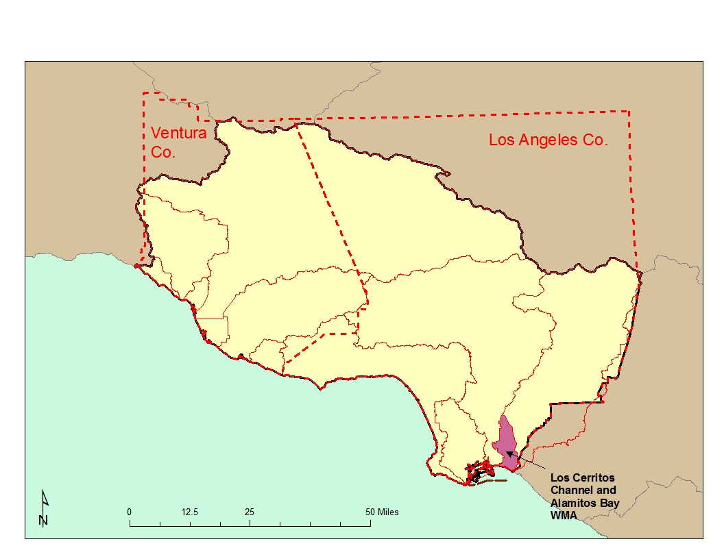
Watershed Description
The Los Cerritos WMA is located between the Los Angeles and San Gabriel Rivers and drains to the same general area as the San Gabriel River. There is also a minor hydraulic connection between the lower San Gabriel River and Los Cerritos Channel due to the location of a power plant intake with the Long Beach Marina; the discharge from this facility is into the San Gabriel River estuary.
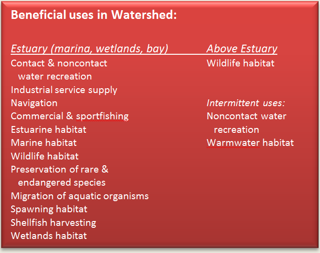
Los Cerritos Channel, Tidal Prism, and Wetlands:The Los Cerritos Channel is concrete-lined above the tidal prism and drains a relatively small area of east Long Beach, albeit a densely urbanized one. The channel’s tidal prism starts at Anaheim Road and connects with Alamitos Bay through the Marine Stadium; the wetlands connect to the Channel a short distance from the lower end of the Channel. The wetlands, and portion of the channel near the wetlands, are an 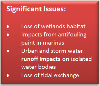 overwintering site for a great diversity of birds despite its small size. An endangered bird species, the Belding's Savannah Sparrow, may nest there and an area adjacent to the wetlands is a historic least tern colony site. One small marina is located in the channel
 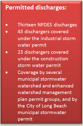 which is also used by rowing teams and is a popular fishing area.
Alamitos Bay: Alamitos Bay is composed of the Marine Stadium, a recreation facility built in 1932 and used for boating, water skiing, and jet skiing; Long Beach Marina, which contains five smaller basins for recreational craft and a boatyard; a variety of public and private berths; and the Bay proper which includes several small canals, a bathing beach, and several popular clamming areas. A small bathing lagoon, Colorado Lagoon in Long Beach, has a tidal connection with the Bay and a small wildlife pond, Sims Pond, also has a tidal connection. The latter is heavily used by overwintering migratory birds.
Water Quality Problems and Issues
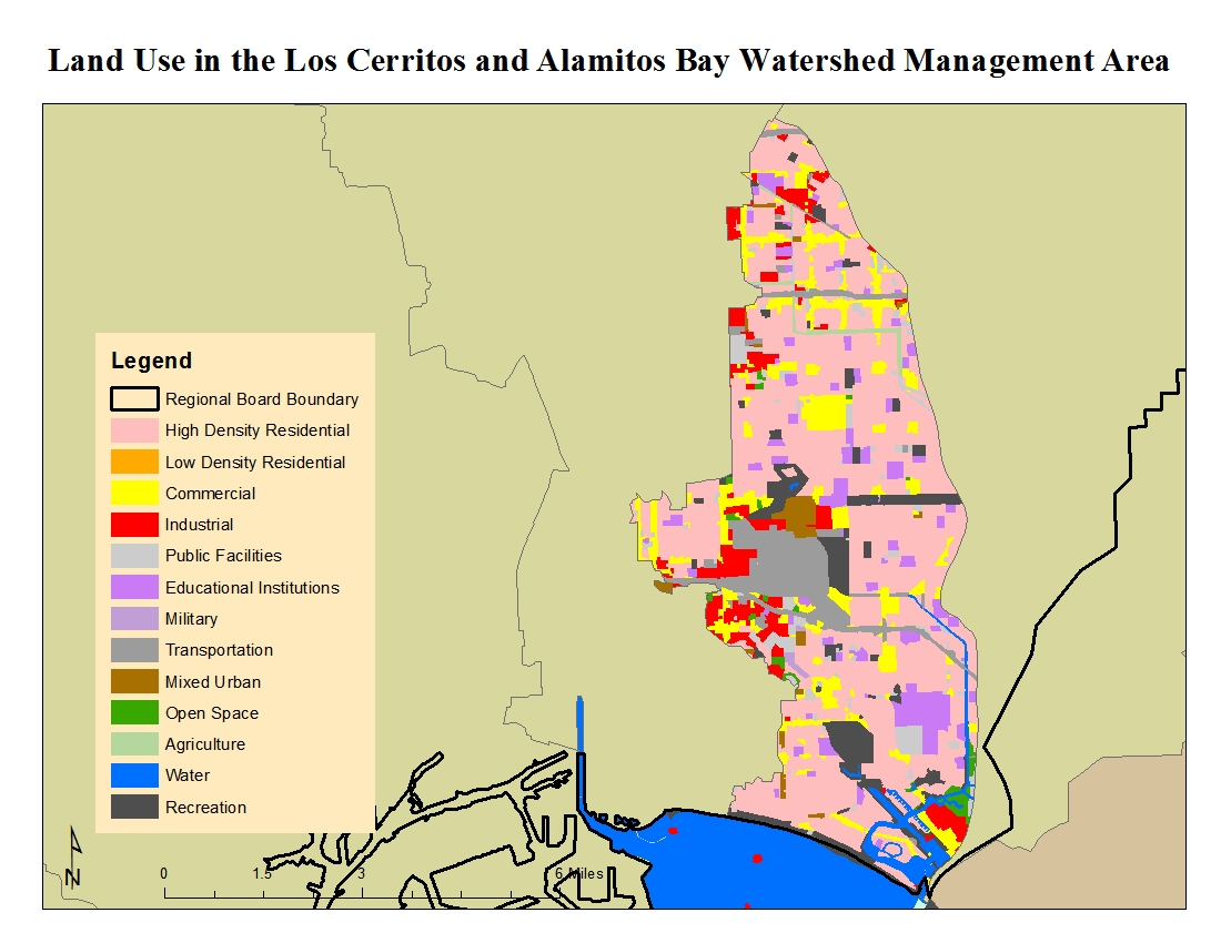
A considerable amount of leaching of boat paint likely occurs in the Bay, particularly in the marina. Nonpoint source runoff from storm drains is also a likely source of problems. A majority of land use in the WMA is high density residential as seen in the figure to the right. Pathogens, metals, and various organic pollutants contribute to the impairments found in the WMA. A considerable amount of water quality data are available on the California Environmental Data Exchange Network at
http://www.ceden.org and on the My Water Quality web portal at
http://www.mywaterquality.ca.gov/index.shtml.
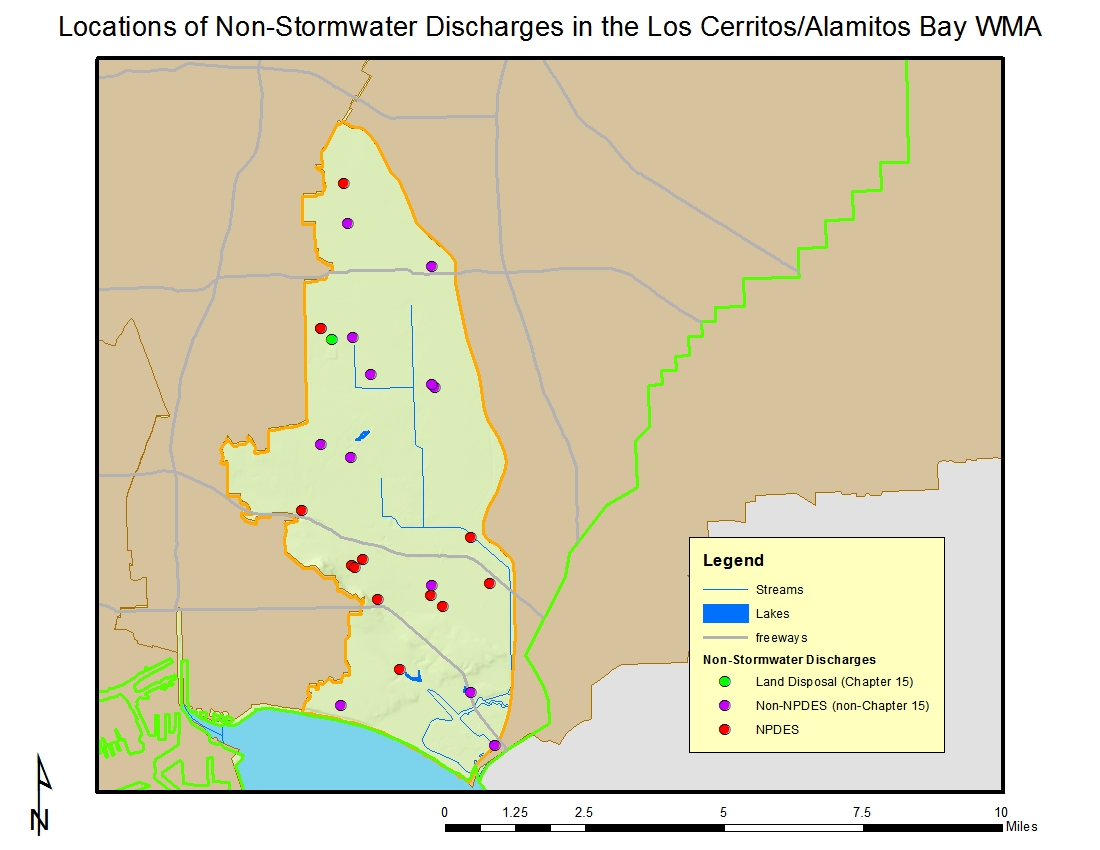
The locations of facilities with discharges to surface water or to the ground (other than those covered by general industrial or construction stormwater permits) are shown on the next page.
Most of the 13 NPDES peritees in the watershed discharge to Los Cerritos Channel; the rest discharge to Alamitos Bay as can be seen in the map below.
 Of the 43 dischargers enrolled under the general industrial storm water permit in the watershed, the majority occur in the cities of Long Beach. Many of these businesses are involved with trucking and warehousing, transportation equipment, and fabricated metal products based on their Standard Industrial Classification (SIC) codes.
 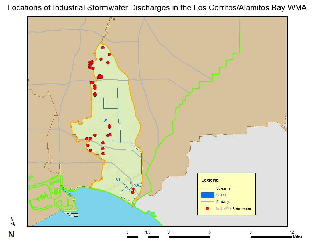 The locations of facilities with discharges covered by the general industrial stormwater permit are shown on the next page.
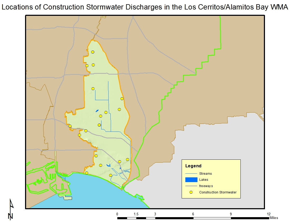
There are 23 construction sites enrolled under the general construction
storm water permit. Sites are fairly evenly divided between commercial, residential, and industrial sites as seen in the map below. About one-half of them occur on sites that are five acres or greater. Sites range up to 200 acres in size.
Click on the link for a complete list of permits in the watershed.
Beneficial uses in the wetlands area are considered fully supported while those in the channel are not. Beneficial uses in the Bay are, for the most part, considered fully supported although Long Beach Marina is considered a site of concern due to elevated sediment concentrations of metals.
Click on the link to obtain a complete list of water quality impairments.
Regional Board Actions to Address Impairments
A number of Regional Board programs and actions are in place to address the water quality impairments noted earlier.
Total Maximum Daily Loads (TMDLs) have been developed (as required by the Clean Water Act) for many of the impairments in the watershed. The TMDL is a number that represents the assimilative capacity of a receiving water to absorb a pollutant and is the sum of the individual wasteload allocations for point sources, load allocations for nonpoint sources plus an allotment for natural background loading, and a margin of safety. TMDLs can be expressed in terms of mass per time (the traditional approach) or in other ways such as toxicity or a percentage reduction or other appropriate measure relating to a water quality objective. A TMDL is implemented by reallocating the total allowable pollution among the different pollutant sources (through the permitting process or other regulatory means) to ensure that the water quality objectives are achieved. TMDLs in effect include those for metals in Los Cerritos Channel (established by USEPA) and for
pesticides, PAHs, PCBs, and metals in Colorado Lagoon. Additional information on these TMDLs may be found at https://www.waterboards.ca.gov/losangeles/water_issues/programs/tmdl/.
The municipal discharges of storm water and non-storm water by the Los Angeles County Flood Control District, the County of Los Angeles, and 84 incorporated cities within the coastal watersheds of Los Angeles County with the exception of the City of Long Beach (hereinafter referred to separately as Permittees and jointly as the Dischargers) from all Municipal Storm Sewer System (MS4 – commonly known as the storm drain system) within Los Angeles County with the exception of Long Beach are subject to waste discharge requirements which were adopted in 2012. Both storm water and non-storm water from the MS4 is subject to the permit requirements. The permit effectively prohibits non-storm discharges into the MS4 and receiving waters with certain exceptions. It also requires that treatment control BMPs be designed to meet certain performance criteria, that each Permittee implement programs and measures to comply with the TMDLs’ waste load allocations for the MS4 specified in the permit, and that regular inspections of various types of commercial facilities be undertaken. A monitoring program must also be implemented. Certain provisions of the permit are organized by watershed management area, which is appropriate given the requirements to implement 33 watershed-based TMDLs.
The MS4 Permittees are allowed the flexibility to develop Watershed Management Programs to implement requirements in the permit on a watershed scale through customized strategies, control measures, and BMPs. Participation in a Watershed Management Program is voluntary and allows a
Permittee to address the highest watershed priorities. Customized strategies, control measures, and BMPs shall be implemented on a watershed basis, where applicable, through each Permittee’s storm water
management program and/or collectively by all participating Permittees through a Watershed Management Program (WMP). Permittees may elect to develop an enhanced Watershed Management
Program (EWMP). An EWMP is one that comprehensively evaluates opportunities, within the participating Permittees’ collective jurisdictional area in a Watershed Management Area, for collaboration among Permittees and other partners on multi-benefit regional projects that, wherever feasible, retain all
non-storm water runoff and all storm water runoff from the 85th percentile, 24-hour storm event for the drainage areas tributary to the projects, while also achieving other benefits including flood control and water supply, among others. Permittees have formed a Los Cerritos Channel Watershed Group (WMP) with an option to convert to an EWMP. More information about this permit may be found at https://www.waterboards.ca.gov/losangeles/water_issues/programs/stormwater/municipal/index.shtml#los_angeles.
Municipal storm water and urban runoff discharges from the MS4 owned and operated by the City of Long Beach are covered by separate waste discharge requirements. More information about this permit may be found at https://www.waterboards.ca.gov/losangeles/water_issues/programs/stormwater/municipal/index.shtml#long_beach
The regulatory and permitting issues surrounding the dredging and disposal of often contaminated sediments in marinas are complex. Regional Board staff participates on an interagency team called the Southern California Dredged Material Management Team (SC-DMMT) which was established for the coordinated review of dredging projects and dredging policy issues within the Southern California area, including Los Angeles and Ventura Counties. In Los Angeles County, selected dredging projects are reviewed through the Los Angeles Regional Contaminated Sediment Task Force (CSTF) which was established through legislation in 1997 and with which Regional Board staff also participates. The CSTF developed a long-term management plan for dredging and disposal of contaminated sediments in the Los Angeles area. The CSTF also formulated guidelines for an Advisory Committee to conduct a coordinated project review of dredging activities in the Los Angeles region. Currently, the CSTF Advisory Committee evaluates proposed dredging and disposal projects, including pre-application planning, and evaluation of sampling results.
Activities Led by Watershed Stakeholders
Stakeholders within the area under the jurisdiction of the Los Angeles Regional Board have formed several long-range water planning groups and have developed Integrated Regional Water Management (IRWM) Plans under Propositions 50 and 84. These Plans address the future water needs of each IRWM Region in terms of reliability of the water supply, improvement to water quality (including implementing TMDLs), increases in habitat and open space (additionally serving as areas for recharge of stormwater), and replacement of water-related infrastructure as needed. They also propose projects to help implement the Plan’s goals; applicants may pursue funding through a variety of sources including grant funding available through bond programs.
Stakeholders in a large portion of Los Angeles County joined together to develop the Integrated Regional Water Management (IRWM) Plan for Greater Los Angeles County (GLAC). Part of the GLAC overlaps with the Los Cerritos WMA. The website for the group is http://www.lawaterplan.org. Within the southeastern portion of Los Angeles County, generally overlying the Central Groundwater Basin, another IRWM Region was formed, the Los Angeles Gateway IRWM Region. The Gateway Region overlaps with the Los Cerritos WMA. Their website is http://www.gatewayirwmp.org.
A feasibility study for restoration of Colorado Lagoon was funded by the Coastal Conservancy. The lagoon is a tidal water body connected to Alamitos Bay via a box culvert. The lagoon is heavily utilized for recreational activities; it is in a natural low point of the watershed and thus receives a considerable amount of urban runoff and has impaired water quality. The purpose of the Colorado Lagoon Restoration Feasibility Study is to evaluate and recommend feasible opportunities to restore the marine ecosystem and support safe recreation while improving water and sediment quality and managing storm water in the lagoon. The City of Long Beach was awarded Clean Beaches Initiative funds from the State Water Resources Control Board to begin implementation of water quality improvement actions described in the feasibility study. More information on the study may be found at http://www.longbeach.gov/news/displaynews.asp?NewsID=561. The Friends of Colorado Lagoon has been actively involved with work at the lagoon. More information can be found at http://www.coloradolagoon.org/ .
Development of a conceptual wetlands restoration feasibility study is currently underway for the Los Cerritos Wetlands led by funding from the State Coastal Conservancy. A multi-agency technical committee is advising the project management team on its development. More information can be found at http://scc.ca.gov/webmaster/ftp/pdf/sccbb/2011/1109/20110922Board08_Los_Cerritos_Wetlands.pdf and at http://www.intoloscerritoswetlands.org/restoration.php.