Watershed Description
 The San Gabriel River receives drainage from 689 square miles of eastern Los Angeles County; its headwaters originate in the San Gabriel Mountains. The watershed consists of extensive areas of undisturbed riparian and woodland habitats in its upper reaches. Much of the watershed of the West Fork and East Fork of the river is set aside as a wilderness area; other areas in the upper watershed are subject to heavy recreational use. The upper watershed also contains a series of flood control dams. Further downstream, towards the middle of the watershed, are large spreading grounds utilized for groundwater recharge. The watershed is hydraulically connected to the Los Angeles River through the Whittier Narrows Reservoir (normally only during high storm flows). The lower part of the river flows through a concrete-lined channel in a heavily urbanized portion of the county before becoming a soft bottom channel once again near the ocean in the city of Long Beach. Large electrical power poles line the river along the channelized portion; nurseries, small stable areas, and storage facilities are located in these areas.
Part of the Coyote Creek Subwatershed is in Orange County and is under the authority of the Santa Ana Regional Water Quality Control Board.
Additional information about the watershed and its many diversion structures and recharge areas can be found in a “State of the Watershed” report prepared by Regional Board staff in 2000. The report can be downloaded at http://www.waterboards.ca.gov/losangeles/water_issues/programs/regional_program/Water_Quality_and_Watersheds/water_report/SanGabrielRiverState.shtml.
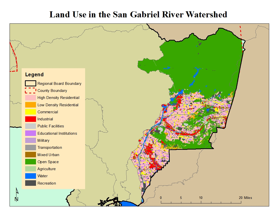
Land use in the watershed is diverse and ranges from predominantly open space in the upper watershed to urban land uses in the middle and lower parts of the watershed as seen in the following figure.
 Water Quality Problems and Issues
Pollutants from dense clusters of residential and commercial activities have impaired water quality in the middle and lower watershed. Tertiary effluent from several sewage treatment plants enters the river in its middle reaches (which is partially channelized) while two power generating stations discharge cooling water into the river's estuary. The watershed is also covered under two municipal storm water NPDES permits. Several landfills are also located in the watershed.
 Several reservoirs, which exist primarily for flood control purposes, are located in the upper part of the watershed. Frequent removal of accumulated sediments is necessary to maintain the flood control capacity of these reservoirs. Some of the removal methods previously used have had water quality impacts. Continued need for such maintenance could cause longer-term impacts.
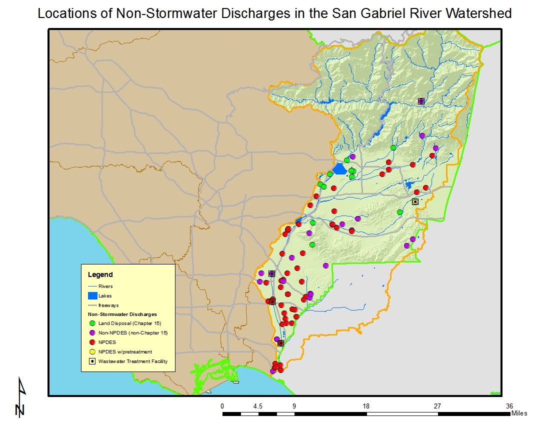
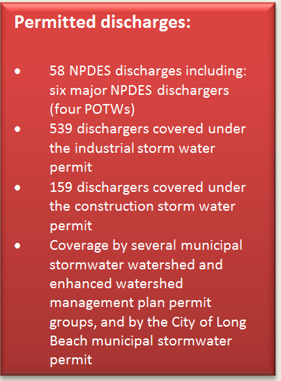
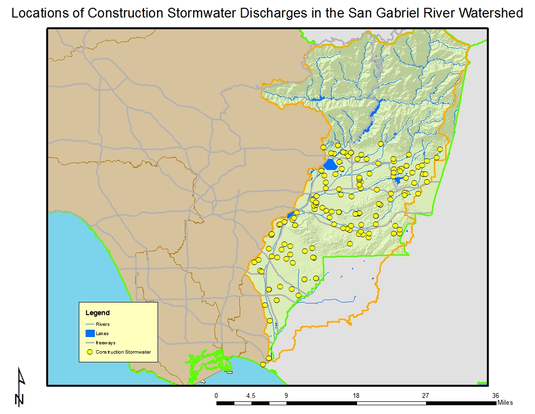
The locations of facilities with discharges to surface water or to the ground (other than those covered by general industrial or construction stormwater permits)are shown in the following figure. Click on the link to obtain a complete list of permitted discharges.
A majority of the 58 NPDES permittees in the watershed discharge directly to the San Gabriel River which fewer numbers discharge to Coyote and San Jose Creeks.
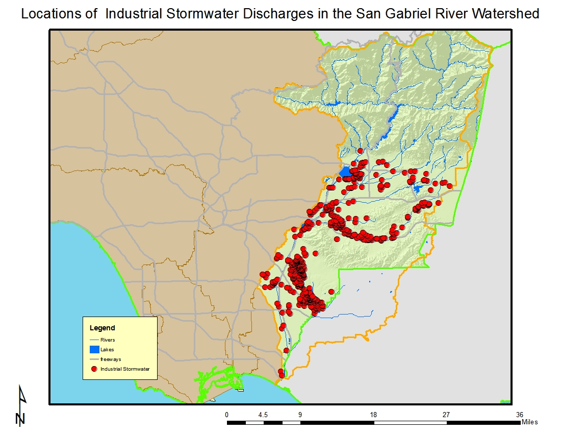
Of the 539 dischargers enrolled under the general industrial storm water permit in the watershed, the largest numbers occur in the cities of Industry, Irwindale, Pomona, and Santa Fe Springs. Fabricated metal products, trucking & warehousing, chemicals and allied products, and rubber and miscellaneous plastic products are a large component of these businesses based on their Standard Industrial Classification (SIC) codes. The locations of facilities with discharges covered by the general industrial stormwater permit are shown in the figure to the left.
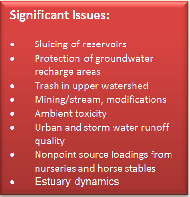
 The upper reaches of the river (in the Angeles National Forest) are heavily used for recreational purposes and have been impacted from trash, debris, and habitat destruction. Various reaches of the river are on the 2010 303(d) list due to nitrogen and its effects, trash, PCBs and pesticides, metals, and coliform for a total of 39 impairments (reach/constituent combinations). A considerable amount of water quality data are available on the California Environmental Data Exchange Network at http://www.ceden.org and on the My Water Quality web portal at http://www.mywaterquality.ca.gov/index.shtml. Click on the link to obtain a complete list of water quality impairments.
Regional Board Actions to Address Impairments
A number of Regional Board programs and actions are in place to address the water quality impairments noted earlier.
Total Maximum Daily Loads (TMDLs) have been developed (as required by the Clean Water Act) for many of the impairments in the watershed. The TMDL is a number that represents the assimilative capacity of a receiving water to absorb a pollutant and is the sum of the individual wasteload allocations for point sources, load allocations for nonpoint sources plus an allotment for natural background loading, and a margin of safety. TMDLs can be expressed in terms of mass per time (the traditional approach) or in other ways such as toxicity or a percentage reduction or other appropriate measure relating to a water quality objective. A TMDL is implemented by reallocating the total allowable pollution among the different pollutant sources (through the permitting process or other regulatory means) to ensure that the water quality objectives are achieved. TMDLs in effect in various parts of the watershed include those for metals and trash. Additional information on these TMDLs may be found at http://www.waterboards.ca.gov/losangeles/water_issues/programs/tmdl/.
The municipal discharges of storm water and non-storm water by the Los Angeles County Flood Control District, the County of Los Angeles, and 84 incorporated cities within the coastal watersheds of Los Angeles County with the exception of the City of Long Beach (hereinafter referred to separately as Permittees and jointly as the Dischargers) from all Municipal Storm Sewer Systems (MS4 – commonly known as the storm drain system) within Los Angeles County with the exception of Long Beach are subject to waste discharge requirements which were adopted in 2012. Both storm water and non-storm water from the MS4 is subject to the permit requirements. The permit effectively prohibits non-storm discharges into the MS4 and receiving waters with certain exceptions. It also requires that treatment control BMPs be designed to meet certain performance criteria, that each Permittee implement programs and measures to comply with the TMDLs’ waste load allocations for the MS4 specified in the permit, and that regular inspections of various types of commercial facilities be undertaken. A monitoring program must also be implemented. Certain provisions of the permit are organized by watershed management area, which is appropriate given the requirements to implement 33 watershed-based TMDLs.
The MS4 Permittees are allowed the flexibility to develop Watershed Management Programs to implement requirements in the permit on a watershed scale through customized strategies, control measures, and BMPs. Participation in a Watershed Management Program is voluntary and allows a
Permittee to address the highest watershed priorities. Customized strategies, control measures, and BMPs shall be implemented on a watershed basis, where applicable, through each Permittee’s storm water
management program and/or collectively by all participating Permittees through a Watershed Management Program (WMP). Permittees may elect to develop an enhanced Watershed Management
Program (EWMP). An EWMP is one that comprehensively evaluates opportunities, within the participating Permittees’ collective jurisdictional area in a Watershed Management Area, for collaboration among Permittees and other partners on multi-benefit regional projects that, wherever feasible, retain all
non-storm water runoff and all storm water runoff from the 85th percentile, 24-hour storm event for the drainage areas tributary to the projects, while also achieving other benefits including flood control and water supply, among others. Permittees have formed several EWMP groups within the San Gabriel River Watershed which include the Rio Hondo/San Gabriel River Water Quality, Upper San Gabriel, East San Gabriel Valley WMA, and Lower San Gabriel River Groups. Several other permittees are developing individual WMPs including: El Monte, Irwindale, South El Monte, Walnut, and West Covina. More information about this permit may be found at http://www.waterboards.ca.gov/losangeles/water_issues/programs/stormwater/municipal/index.shtml#los_angeles.
Municipal storm water and urban runoff discharges from the MS4 owned and operated by the City of Long Beach are covered by separate waste discharge requirements. More information about this permit may be found at http://www.waterboards.ca.gov/losangeles/water_issues/programs/stormwater/municipal/index.shtml#long_beach.
A number of TMDLs contain load allocations assigned to irrigated agriculture. The Regional Board adopted a conditional waiver for discharges from irrigated lands (see http://www.waterboards.ca.gov/losangeles/water_issues/programs/tmdl/waivers/index.shtml) which requires agricultural interests to monitor and implement various best management practices as needed to improve the quality of runoff from irrigated lands. This can be accomplished by growers either individually or through joining a group effort; within Los Angeles County, growers are organized into the Nursery Growers Association Los Angeles County Irrigated Lands Group.(NGA).
Activities Led by Watershed Stakeholders
Stakeholders within the area under the jurisdiction of the Los Angeles Regional Board have formed several long-range water planning groups and have developed Integrated Regional Water Management (IRWM) Plans under Propositions 50 and 84. These Plans address the future water needs of each IRWM Region in terms of reliability of the water supply, improvement to water quality (including implementing TMDLs), increases in habitat and open space (additionally serving as areas for recharge of stormwater), and replacement of water-related infrastructure as needed. They also propose projects to help implement the Plan’s goals; applicants may pursue funding through a variety of sources including grant funding available through bond programs.
Stakeholders in a large portion of Los Angeles County joined together to develop the Integrated Regional Water Management (IRWM) Plan for Greater Los Angeles County (GLAC). Parts of two subregions of the GLAC fall within the San Gabriel River Watershed. The website for the group is http://www.lawaterplan.org. Within the southeastern portion of Los Angeles County, generally overlying the Central Groundwater Basin, another IRWM Region was formed, the Los Angeles Gateway IRWM Region. Part of the Region falls within the San Gabriel River Watershed. Their website is http://www.gatewayirwmp.org.
The Los Angeles Basin Stormwater Conservation Study is being undertaken by the Los Angeles County Department of Public Works and the U.S. Department of the Interior, Bureau of Reclamation. The purpose of this proposed Basin Study is to identify alternatives, conduct trade-off analyses and develop recommendations to help bridge the gap between current and future water supply and water demand in the Basin Study watersheds (Los Angeles River, San Gabriel River, Ballona Creek, Dominguez Channel/Los Angeles Harbor, North Santa Monica Bay, South Santa Monica Bay, and Malibu Creek), taking into account climate change and population growth projections. The Basin Study will analyze imbalances in supply and demand by conducting a literature review of all water inputs and outputs. The Basin Study will identify issues where changes to the operation of water supply systems, modifications to existing facilities, development of new facilities, or non-structural changes by the Los Angeles County Flood Control District and its partners could help address water supply needs.
The National Park Service undertook a Special Resource Study of the San Gabriel Watershed and Mountains in order to determine the area’s eligibility to become a unit of the national park system. The study was completed in 2013 and determined that the study area was eligible to be a unit of the national park system based on its nationally significant resources, the mix of resources, and the feasibility for the National Park Service to be involved in a collaborative management role providing conservation planning assistance (as opposed to a traditional national park). Areas of the San Gabriel Mountain foothills, portions of the San Gabriel and Rio Hondo river corridors, and the western Puente Hills would be recommended designated a San Gabriel unit of the Santa Monica Mountains National Recreation Area. The recommendation will need Congressional legislation to implement. More information can be found at http://www.nps.gov/pwro/sangabriel/.
The nonprofit organization Council for Watershed Health was formed in 1995 (as the Los Angeles and San Gabriel Rivers Watershed Council) following a large watershed conference held in the area which served as a springboard for other efforts. The Council has a board of directors and became incorporated as a nonprofit organization in 1996. The group is involved with many watershed activities, as well as opportunities to create greenbelts and restore habitat. More information on this group may be found on their website http://www.watershedhealth.org.
The San Gabriel River Regional Monitoring Program (SGRRMP) was developed by multiple stakeholders in the watershed in cooperation with the Regional Board and USEPA staff, as well as with the major dischargers in the watershed. The POTWs in the watershed participate in the implementation of the SGRRMP as described in their permits’ monitoring and reporting program. The objectives of the program are to increase awareness of the importance of issues at the watershed scale and to improve the coordination and integration of monitoring efforts for both compliance and ambient conditions. The SGRRMP has incorporated some elements of traditional water quality and biological monitoring that focus around discharge points and extended this to cover the entire watershed. Its sampling design, which integrates both randomized and targeted sampling at fixed sites, provides the ability to track trends at these fixed sites and evaluate them in the context of conditions in the watershed as a whole (random sites). The SGRRMP’s approach allows for integrating ambient and permit-mandated monitoring to provide a more consistent and complete picture of conditions in the watershed relevant to the questions that concern managers and the public. The Council for Watershed Health serves as the coordinator for the monitoring and also reports on the results at http://www.watershedhealth.org/programsandprojects/sgrrmp.aspx.
Amigos de los Rios is a nonprofit organization working with cities and residents to renew urban neighborhoods. A current project being worked on is the Emerald Necklace, a vision for a 17 mile loop of parks and greenways connecting 10 cities and nearly 500,000 residents along the Río Hondo and San Gabriel Rivers. More information about the organization may be found at http://www.amigosdelosrios.org/.
The San Gabriel and Lower Los Angeles Rivers and Mountains Conservancy (RMC) produced a Watershed and Open Space Plan for the San Gabriel and Los Angeles Rivers which may be obtained at http://www.rmc.ca.gov/plans/intro.html . The Conservancy is an independent State agency within the Resources Agency of the State of California established by state law in 1999. Its jurisdiction includes the San Gabriel River and its tributaries, the Lower Los Angeles River and its tributaries, and the San Gabriel Mountains, Puente Hills, and San Jose Hills. It was established to preserve urban open space and habitats in order to provide for low-impact recreation and educational uses, wildlife and habitat restoration and protection, and watershed improvements within its jurisdiction. Implementation of the Open Space Plan is occurring partly through award of pass-through grant funds.
In 2007, multiple collaborators, led by the Southern California Coastal Water Research Project, released a report entitled Historical Ecology and Landscape Change of the San Gabriel River and Floodplain which can be downloaded at http://ftp.sccwrp.org/pub/download/DOCUMENTS/TechnicalReports/499_historical_ecology.pdf. The historical ecology project established many of the methods that are now being used elsewhere in the state to document the historical extent and function of wetlands riparian resources. The work documented extensive wetlands, particularly alkali meadows, in the lower elevations of the watershed that have since been replaced by urbanized areas.
In 1999, the Los Angeles County Board of Supervisors directed the Department of Public Works to prepare a San Gabriel River Master Plan which has since been adopted by the County Board of Supervisors. The Master Plan identifies project opportunities for: enhancements for recreation, open space, and habitat areas; restoration; preservation of the River's natural resources; and maintaining flood protection and existing water rights. Documents relating to the Master Plan may be obtained at http://www.sangabrielriver.com/.
The County of Orange, in coordination with the County of Los Angeles and multiple stakeholders in both counties, completed the Coyote Creek Watershed Management Plan in 2008; Coyote Creek is a subwatershed of the San Gabriel River which straddles two counties and two Regional Board jurisdictions. The creek enters the San Gabriel River near the ocean and the subwatershed area covers a densely populated area of southeastern Los Angeles County and northern Orange County. The watershed management plan is available for download at http://www.rmc.ca.gov/plans/water.html .