Eureka Plain
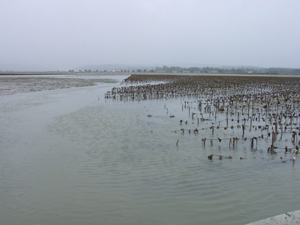
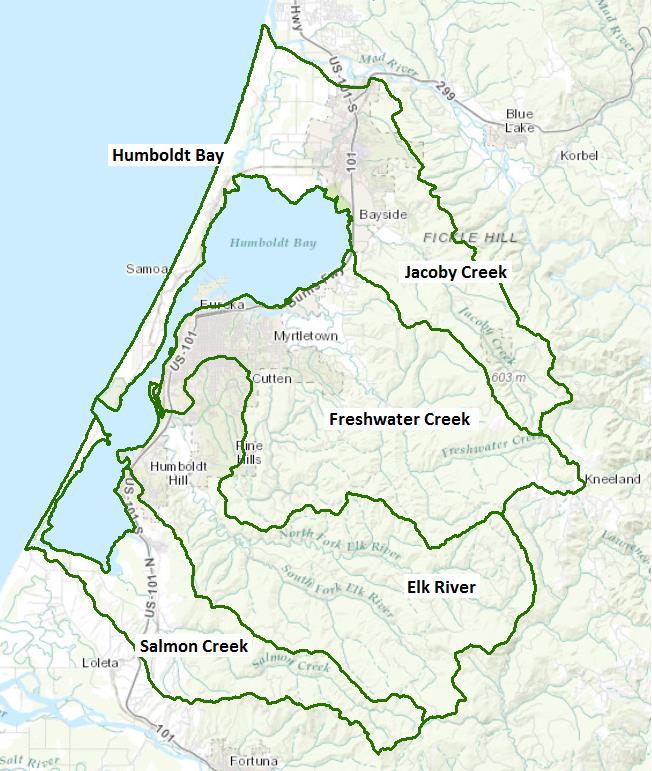
This Unit encompasses Humboldt Bay and the watersheds that drain into Humboldt Bay, primary among them, Jacoby, Freshwater, and Salmon creeks and Elk River. The terrain is coastal hills in the east down to the coastal plain in the west. Vegetation consists of redwood and Douglas fir interspersed with some hardwoods and meadows. The plains area is typified by pasture land and freshwater and saltwater wetlands with some limited cultivation. Land use is primarily timber production, with agricultural uses in the non-forested areas consisting primarily of grazing and dairies. Precipitation ranges from 32 to 98 inches annually, mostly rain.
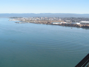
Freshwater streams support production of anadromous salmonids, including steelhead and cutthroat trout, and coho and Chinook salmon. Humboldt Bay is an important commercial and recreational shellfish growing area, as well as deep-water port. It is a major shipping center for the north coast, the largest such center between San Francisco and Coos Bay, Oregon.
The Eureka Waterfront has been the site of several industrial operations including lumber mills, bulk oil storage and handling facilities, wrecking yards, and railroad yards. These operations produced both soil and ground water contamination with heavy metals, petroleum products, and pentachlorophenols (PCPs). The Waterfront is currently undergoing cleanup and redevelopment. The City of Eureka is coordinating the redevelopment with several responsible parties including Union Pacific Railroad, Simpson Timber Company, Chevron, Unocal, and Tosco oil companies, and a few others.
Separate web pages are available for two of the major tributaries, Freshwater Creek and Elk River:
Water Quality, Flow, and Water Rights
2012 Water Quality Assessment Report
The North Coast Water Board evaluates water quality information and identifies water bodies that do not meet water quality standards and are not supporting their beneficial uses every six years. Those waters are placed on a list of impaired water bodies that identifies the pollutant or stressor causing impairment and establishes a schedule for developing a control plan to address the impairment.
| Impaired Water Bodies in the Eureka Plain Hydrologic Unit | ||
| Water Body Name | Listing Extent | Pollutant |
| Elk River Watershed, Lower Elk River and Martin Slough | Lower mainstem Elk River and Martin Slough Entire water body | Indicator Bacteria Sedimentation/ Siltation |
| Elk River Watershed, Upper Elk River | Entire water body | Sedimentation/ Siltation |
| Elk River Watershed, Upper Little South Fork Elk River | Entire water body | Sedimentation/ Siltation |
| Freshwater Creek | Entire water body | Sedimentation/ Siltation |
| Gannon Slough | Campbell Creek | Indicator Bacteria |
| Humboldt Bay | Entire water body | Dioxin Toxic Equivalents PCBs |
| Jacoby Creek Watershed | Entire water body | Sediment |
| Jolly Giant Creek | Jolly Giant Creek | Indicator Bacteria |
Main program page:
Map of water quality listed segments. (Click on the map tab)
Facilities Regulated by the Regional Water Board
This link is an interactive map of permitted facilities in California. You can zoom in to the watershed of your choice and click on a facility to obtain information.
Sanitary Sewer Overflow Incident Map
This link is an interactive map of overflows from sanitary sewers. You can zoom in to the watershed of your choice and click on an incident to obtain information.
2008 North Coast Water Board's Sediment TMDL Implementation Workplan (Jacoby Creek Section)
The Regional Water Board adopted a TMDL implementation policy statement in 2004 and a subsequent Workplan in 2008 that details efforts to address sediment impaired water bodies in the region. The Jacoby Creek section begins on page 131.
Water Rights Database
Statements of water diversion and use, registrations, certificates and water rights permits are accessible on the eWRIMS, electronic Water Rights Information Management System. This link includes a mapping application.
State Water Board Integrated Water Quality Information System
This site provides reports on regulated facilities, including violations, enforcement, and self-monitoring. Searches can be done by county or agency jurisdiction (e.g., Humboldt County, Eureka City, Arcata City, Sierra Pacific Industries).
California Environmental Data Exchange Network
The State Water Resources Control Board maintains this site, which contains water quality and habitat information in a spreadsheet format. Pay careful attention to the instructions.
U.S. Forest Service, Pacific Southwest Research Station
This research arm of the U.S. Forest Service has conducted assessments and hydrologic studies in the Jacoby Creek watershed.
1979 & 1980 Historical Reports on Circulation Patterns in Humboldt Bay
The North Coast Water Board partnered with the State departments of Health Services and Water Resources, and the federal Northeast Technical Services Unit (NETSU) of the Food and Drug Administration in 1979 and 1980 to study circulation patterns in Humboldt Bay. The purpose of the efforts was to gain insight into the potential for contamination of commercial oyster harvest areas from local sewage treatment plant discharges. While these are historical studies, the overall circulation patterns in the bay remain essentially the same.
1979 studies of discharges from sewage treatment plants at Arcata, Eureka Hill Street, and Eureka Murray Street:
NETSU memorandum
Water Board report
1980 Water Board memorandum on Murray Street ebb tide study
1977 Historical North Coast Water Board Report on Log Pond Discharge to Janes Creek
This is an historic report on the effects of a log pond discharge on the water quality and biota in Janes Creek.
Landscape Information
2005 N. Coast Water Board Watershed Initiative Chapter, Humboldt Bay WMA
The North Coast Region developed a Watershed Initiative Chapter as part of the State Water Board's Watershed Management Initiative that provides an overview of that watershed, a description of its water quality concerns and issues, past significant Regional Board activities in the watershed, activities as of 2005, near-term activities that would benefit the watershed, and activities which may happen on a longer time-scale.
California Geographic Information Portal
This portal has a search engine for the portal itself and ArcGIS online. Information and GIS layers can be accessed for a variety of data, including hillshade, vegetation, rivers, contours, stream fish habitat by reach, stream inventory reports, and CalWater 2.2 maps.
CalFire Fire and Resource Assessment Program
This site contains a wealth of information on the amount and extent of forest and rangelands along with analysis of conditions. Maps, projects, and assessments are available on the site, including GIS layers for timber harvesting, vegetation, and other resources.
U.S. Natural Resources Conservation Service Geospatial Data Gateway
Environmental and natural resources GIS files are available at this site.
Watershed Condition Information
KRIS Humboldt Bay
This system was originally developed as a data repository and analysis and management tool for the Klamath River watershed. A host of information is available through this site, including maps, water quality data, fisheries data, photographs, and scientific references.
Humboldt Bay Harbor, Recreation, and Conservation District
This site contains information on current issues in Humboldt Bay as well as information on water, wildlife, fisheries, and commercial resources of the bay and the Humboldt Bay Management Plan.
California EcoAtlas
This website provides access to information on wetlands, including integration of some water quality information.
Watershed Groups, Partnerships, and Collaboration
California Watershed Network
This nonprofit organization was formed in 2000 to help protect and restore watersheds in California through community-based networks.
Humbodt BayKeeper
This environmental organization began in 2004 within the Northcoast Environmental Center with the purpose of safeguarding coastal resources. In addition to "watch dog" efforts, the Baykeeper organizes citizen monitoring and education programs.
Jacoby Creek Land Trust
The land trust is active in and around northern Humboldt Bay with the goals of promoting healthy streams, watershed protection, and sustainable agriculture.
North Coast Resource Partnership
This partnership began in 2004 as the North Coast Integrated Regional Water Management Plan, and is focused on watershed health, water quality, energy independence, adaptation to climate change, and economic vitality of the north coastal area. A number of funding programs are administered through this partnership. The website contains a wealth of information and links on various projects throughout the north coast, including the Humboldt Bay watershed.
Redwood Community Action Agency's Natural Resource Service
This nonprofit group is involved in watershed assessments and restoration activities in the redwood region.
Home page
Humboldt Bay Watershed Salmon and Steelhead Conservation Plan
Salmonid Restoration Federation
This nonprofit group was formed in 1986 to assist salmonid restoration efforts in California by promoting "restoration, stewardship, and recovery of California native salmon, steelhead and trout populations through education, collaboration, and advocacy." Their web site contains a wealth of information on salmonids and habitat and stream restoration in California.
West Coast Ecosystem-based Management Network – Humboldt Bay Initiative
This Sea Grant effort started in 2007 and "seeks to create a coordinated resource management frame work that link the needs of people, habitats and specis by increasing scientific understanding of the ecosystem."
Humboldt Bay EBM webpage and 2009 strategic plan
Fisheries and Wildlife Information
National Oceanic and Atmospheric Administration
NOAA Fisheries is responsible for listing and recovery efforts for anadromous fishes. The 2014 Recovery Plan for coho salmon in the Southern Oregon-North Coast of California ESU contains information on the habitat, population status, stressors and threats, recovery efforts, and recovery strategy.
CA Department of Fish and Wildlife Stream Inventory Reports
This site provides stream inventory reports for major watershed areas (search on Humboldt Bay).
Nature Conservancy California Salmon Snapshots
This site provides information and links for salmon populations and habitat, and projects in Humboldt Bay tributaries.
Green Diamond Resource Company
Green Diamond manages timberlands tributary to Humboldt Bay. Their research arm provides information on the wildlife, fishery, and botanical resources within their lands.
Watershed Projects
California Department of Fisheries and Wildlife Inventory
The CDFW maintains an inventory of monitoring and restoration efforts for Humboldt Bay and the Eel River delta.
UC Davis Information Center for the Environment, Natural Resource Project Inventory
This database provides information on natural resource projects in California, including links to data and information collected by the projects. Search on "Humboldt Bay"
Please Note: The links and information on this page are provided in an attempt to make a broad range of information available on a watershed basis. While the Water Board has been involved in work within watersheds with a variety of agencies and watershed groups, we cannot vouch for the currency or accuracy of information contained within the internet links we have included. We suggest that you check with the original sources if there is any question regarding currency, accuracy, or origin of information.
Created December 30, 2015
Web page contact: Robert Klamt, robert.klamt@waterboards.ca.gov
(Page last updated 8/24/23)
Water is a precious resource in California, and maintaining its quality is of utmost importance to safeguard the health of the public and the environment.
Statewide Campaigns
EPA Water Sense
File an Environmental Complaint
Save Our Water
Flex Alert
Register to Vote
