
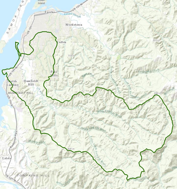
Elk River Watershed - HUCs 110.000201, 202, 301, 302, 401, 402
The Elk River watershed is the largest freshwater tributary to Humboldt Bay and historically provided miles of quality habitat for salmon and steelhead. Typical of Humboldt Bay tributaries, it begins in the coastal hills to the east and flows to the northwest through a flat coastal valley. The climate is characterized by mild winters with high rainfall and a summer dry season. Rainfall amounts increase with elevation from an average of 39 inches per year at Eureka to 60 inches per year near the headwaters.
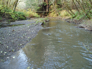
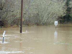
Managed timberlands and livestock grazing are the main land uses in the watershed. A fragile and erodible geology coupled with high and sometimes intense rainfall makes this watershed particularly susceptible to landscape disturbances. The watershed has a storied past with regard to timber harvesting, with accelerated harvest activities in the 1990s causing cumulative impacts to the watershed and stream system. The effects of excessive sedimentation were documented in 1997 as impairments to multiple beneficial uses, including the cold water fishery, domestic water supplies, and agricultural water supplies. Excessive sedimentation also has caused an increased incidence of flooding resulting in permanent or temporary loss or reduced use of both private and public property, as well as risks to the health and welfare of the local community.
Timber harvesting activities in the watershed currently are intensely regulated and monitored. The two major industrial timber land owners, Humboldt Redwoods Company and Green Diamond Resource Company, currently operate under federal Habitat Conservation Plans, Incidental Take Permits, Forest Stewardship Certification, and Water Board permits. The Bureau of Land Management administers the Headwaters Forest Reserve, a 7,400-acre reserve about half of which is old growth redwood groves, in accordance with the Headwaters Forest Resource Management Plan.
The Regional Water Board's most recent visioning process generated a succinct vision statement that forms the basis for the format of this webpage:
Healthy Watersheds, Effective Regulation, Strong Partnerships
Healthy Watersheds – Water Quality
Monitoring & Special Studies
2012 Water Quality Assessment Report & 303(d) List of Impaired Waters
The Water Board evaluates water quality information and identifies water bodies that do not meet water quality standards and are not supporting their beneficial uses. Those waters are placed on a list of impaired water bodies that identifies the pollutant or stressor causing impairment and establishes a schedule for developing a control plan to address the impairment.
Impaired Water Bodies – Eureka Plain Hydrologic Unit |
|||
Water Body Name |
Listing Extent |
Pollutant |
Category |
Elk River Watershed, Lower Elk River and Martin Slough |
Lower mainstem Elk River and Martin Slough Entire water body |
Indicator Bacteria Sedimentation/ Siltation |
5 |
5 |
|||
Elk River Watershed, Upper Elk River |
Entire water body |
Sedimentation/ Siltation |
5 |
Elk River Watershed, Upper Little South Fork Elk River |
Entire water body |
Sedimentation/ Siltation |
5 |
Freshwater Creek |
Entire water body |
Sedimentation/ Siltation |
5 |
Gannon Slough |
Campbell Creek |
Indicator Bacteria |
5 |
Humboldt Bay |
Entire water body |
Dioxin Toxic Equivalents PCBs |
5 5 |
Jacoby Creek Watershed |
Entire water body |
Sediment |
5 |
Jolly Giant Creek |
Jolly Giant Creek |
Indicator Bacteria |
5 |
Main program page:
Map of water quality listed segments. (Click on the map tab)
Elk River TMDL for Sediment
The Elk River watershed is listed for impairments due to excessive sediment, and a TMDL is under development. Plans and documents, including a 2012 Restoration Summit and a 2013 Elk River Forum are under the following link:
If you would like to receive email notifications for the Elk River TMDL, please sign up on the Email List Subscription Form located at:
California Environmental Data Exchange Network
This site, maintained by the State Water Resources Control Board, contains water quality and habitat information in a spreadsheet format. It can be a bit confusing to use, so pay careful attention to the instructions. Search on HUC 12 for Elk River.
2013 Salmon Forever Annual Report on Suspended Sediment, Peak Flows, and Trends
This project provides information on both Elk River and Freshwater Creek in partial fulfillment of a grant agreement between the State Water Resources Control Board and the Redwood Community Action Agency.
Elk River and Freshwater Creek Sediment Monitoring Project
This link provides information on a cooperative sediment monitoring program in these two watersheds from 2008 to 2013.
Assessment of Soil Creep Sediment Generation for Total Maximum Daily Load Development in a Northern Coastal California Watershed, Doctoral Dissertation, Matthew Buffleben, 2009
Various soil creep estimation methods were evaluated with data from three small sub-watersheds in the Elk River watershed.
Suspended Sediment Yields in Tributaries of Elk River, 2004
Suspended sediment yields were estimated using turbidity threshold sampling methodology in three tributaries to Elk River.
Healthy Watersheds – Stream Flow
Water Rights Database
Statements of water diversion and use, registrations, certificates and water rights permits are accessible on the eWRIMS, electronic Water Rights Information Management System. This link includes a mapping application.
2001 Peak Flow Estimates by CalFire
The California Department of Forestry and Fire Protection estimated the effects of past timber harvesting and an annual harvest of 600 acres of clearcut on peak flows in the Elk River watershed.
Healthy Watersheds – Landscape Information
California Geographic Information Portal
This portal has a search engine for the portal itself and ArcGIS online. Information and GIS layers can be accessed for a variety of data, including hillshade, vegetation, rivers, contours, stream fish habitat by reach, stream inventory reports, and CalWater 2.2 maps.
CalFire Fire and Resource Assessment Program
This site contains a wealth of information on the amount and extent of forest and rangelands along with analysis of conditions. Maps, projects, and assessments are available on the site, including GIS layers for timber harvesting, vegetation, and other resources.
U.S. Natural Resources Conservation Service Geospatial Data Gateway
Environmental and natural resources GIS files are available at this site.
2013 Elk River Forum
The Humboldt county Supervisors sponsored this forum with the Friends of Elk River and the Redwood Community Action Agency to provide a forum for discussion. Several folks made presentations and a list of "desired outcomes" for the TMDL was developed. The presentations and further information are provided on the Elk River TMDL web page about half way down under the title of "November 16, 2013 Elk River Forum Sponsored by the Humboldt County Board of Supervisors."
2005 Pacific Lumber Company (PALCO) Watershed Analysis
Pacific Lumber Company performed a multi-agency watershed analysis for Elk River in partial fulfillment of obligations with their Habitat Conservation Plan to identify existing conditions and describe the physical and biological processes within the watershed.
2002 and 2003 Independent Science Review Panel Reports
The North Coast Water Board convened an Independent Science Review Panel (ISRP) to review scientific information on the condition, biological resources, and water quality of five watersheds in Humboldt County, one of which was Elk River, with an eye to past, present, and proposed land use management, primarily timber harvest. Two reports were produced, termed "Phase I" (December 27, 2002) and "Phase II" (August 12, 2003).
Phase I ISRP Report
Phase II ISRP Report
KRIS Humboldt Bay
This system was originally developed as a data repository and analysis and management tool for the Klamath River watershed. A host of information is available through this site, including maps, water quality data, fisheries data, photographs, and scientific references.
California EcoAtlas
This website provides access to information on wetlands, including integration of some water quality information.
Healthy Watersheds – Fish and Wildlife
National Oceanic and Atmospheric Administration
NOAA Fisheries is responsible for listing and recovery efforts for anadromous fishes. The 2014 Recovery Plan for coho salmon in the Southern Oregon-North Coast of California ESU contains information on the habitat, population status, stressors and threats, recovery efforts, and recovery strategy.
CA Department of Fish and Wildlife Stream Inventory Reports
This California DFW site allows searches by major watershed areas (search on Humboldt Bay).
California Trout
CalTrout has a number of projects throughout the state, including a recovery assessment for Elk River.
Effective Regulation – Management Activities
2008 North Coast Water Board's Sediment TMDL Implementation Workplan
The Regional Water Board adopted a TMDL implementation policy statement in 2004 and a subsequent Workplan in 2008 that details efforts to address sediment impaired water bodies in the region
Bureau of Land Management Sediment Delivery Site Remediation – S. Fork Elk River
This project was implemented to reduce sediment delivery from sites in both the South Fork Elk River and Salmon Creek and was funded by the USEPA nonpoint source grant program.
The Bureau of Land Management website for the Headwaters Forest Reserve
Effective Regulation – Water Rights
Water Rights Database
Statements of water diversion and use, registrations, certificates and water rights permits are accessible on the eWRIMS, electronic Water Rights Information Management System. This link includes a mapping application.
Strong Partnerships – Stewardship Efforts
California Trout Elk River Recovery Assessment and Community Stewardship Program
This watershed stewardship program will address water quality and sediment impairments in the Elk River watershed.
Coastal Conservancy grant recommendation – April 2013
California Watershed Network
This nonprofit organization was formed in 2000 to help protect and restore watersheds in California through community-based networks.
Strong Partnerships – Projects
Salmonid Restoration Federation
This nonprofit group was formed in 1986 to assist salmonid restoration efforts in California by promoting "restoration, stewardship, and recovery of California native salmon, steelhead and trout populations through education, collaboration, and advocacy." Their web site contains a wealth of information on salmonids and habitat and stream restoration in California.
UC Davis Information Center for the Environment, Natural Resource Project Inventory
This database provides information on natural resource projects in California, including links to data and information collected by the projects.
Please Note: The links and information on this page are provided in an attempt to make a broad range of information available on a watershed basis. While the Water Board has been involved in work within watersheds with a variety of agencies and watershed groups, we cannot vouch for the currency or accuracy of information contained within the internet links we have included. We suggest that you check with the original sources if there is any question regarding currency, accuracy, or origin of information.
Created January 28, 2015
Web page contact: Robert Klamt, robert.klamt@waterboards.ca.gov
(Page last updated 8/29/23)
Water is a precious resource in California, and maintaining its quality is of utmost importance to safeguard the health of the public and the environment.
Statewide Campaigns
EPA Water Sense
File an Environmental Complaint
Save Our Water
Flex Alert
Register to Vote
