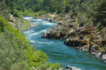
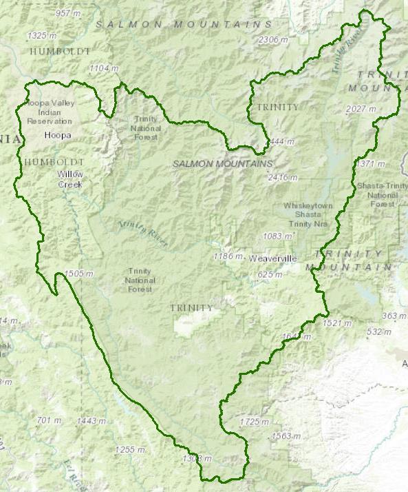
Trinity River Watershed - Hydrologic Unit 106
The Trinity River flows from the Trinity Alps in northwestern California through steep canyons and picturesque river valleys to its confluence with the Klamath River at Weitchpec. Large populations of salmon and steelhead have used the river for thousands of years. The interbasin transfer of a majority of the flow into the central valley of California along with watershed perturbations have altered the environment for these highly prized fish. Restoration efforts, including court decisions regarding flow regimes, have been underway since the 1990s to help restore the structure and function of the river and its watershed. The Trinity River mainstem from Lewiston downstream to the North Fork Trinity River and the North Fork Trinity River are federally designated Wild and Scenic Rivers.
Water Quality, Flow, and Water Rights
2012 Water Quality Assessment Report
Every six years the North Coast Water Board evaluates water quality information and identifies water bodies that do not meet water quality standards and are not supporting their beneficial uses. Those waters are placed on a list of impaired water bodies that identifies the pollutant or stressor causing impairment and establishes a schedule for developing a control plan to address the impairment.
Impaired Water Bodies in the Trinity River Hydrologic Unit |
||
Water Body Name |
Listing Extent |
Pollutant |
Lower Trinity River HA |
Entire water body except: (1) the New River and its tributaries, (2) Big French Creek and its tributaries, (3) the North Fork Trinity River and its tributaries, including the East Fork North Fork Trinity River and its tributaries, and (4) Manzanita Creek and its tributaries. |
Sedimentation/ Siltation |
Middle Trinity River HA |
Entire water body |
Sedimentation/Siltation |
South Fork Trinity HA |
Entire water body |
Sedimentation/Siltation Temperature |
Trinity Lake |
Entire water body |
Mercury |
Upper Trinity River HA |
Entire water body except the Stuart Fork and its tributaries |
Sedimentation/ Siltation |
Upper Trinity HA, Trinity River, East Fork Trinity River |
Entire water body |
Mercury Sedimentation/Siltation |
Main program page:
Map of water quality listed segments. (Click on the map tab)
Trinity River TMDLs for Sediment
The US Environmental Protection Agency established two technical Total Maximum Daily Loads for sediment in the Trinity River watershed: the South Fork in 1998, followed by the Trinity River watershed in 2001.
1998 South Fork Trinity River TMDL
2001 Trinity River TMDL
Facilities Regulated by the Regional Water Board
This link is an interactive map of permitted facilities in California. You can zoom in to the watershed of your choice and click on a facility to obtain information.
Sanitary Sewer Overflow Incident Map
This link is an interactive map of overflows from sanitary sewers. You can zoom in to the watershed of your choice and click on an incident to obtain information.
2008 North Coast Water Board Sediment TMDL Implementation Policy
The Regional Water Board adopted a TMDL implementation policy statement in 2004 and a subsequent Workplan in 2008 that details efforts to address sediment impaired water bodies in the region. The section starting on page 215 is specific to the Trinity River watershed
Water Temperature Site-specific Objective
Site-specific objectives for water temperature were developed in 1991 for the Trinity River from Lewiston Dam downstream to the confluence with the North Fork Trinity River. They are under footnote "5" in Table 3-1 of the Water Quality Control Plan for the North Coast Region (Basin Plan).
Office of Environmental Health and Hazard Assessment Fish Consumption Advisories
Trinity Lake and East Fork Trinity River
Lewiston Lake, Carrville Pond, and the Trinity River Upstream from Trinity Lake
Water Rights Database
Statements of water diversion and use, registrations, certificates and water rights permits are accessible on the eWRIMS, Electronic Water Rights Information Management System. This link includes a mapping application.
California Environmental Data Exchange Network
Water quality and habitat data and information are contained at this site in a spreadsheet format. Pay careful attention to the instructions.
Landscape Information
2005 N. Coast Water Board Watershed Initiative Chapter, Trinity River WMA
The North Coast Region developed a Watershed Initiative Chapter as part of the State Water Board's Watershed Management Initiative that provides an overview of that watershed, a description of its water quality concerns and issues, past significant Regional Board activities in the watershed, activities as of 2005, near-term activities that would benefit the watershed, and activities which may happen on a longer time-scale.
California Geographic Information Portal
This portal has a search engine for the portal itself and ArcGIS online. Information and GIS layers can be accessed for a variety of data, including hillshade, vegetation, rivers, contours, stream fish habitat by reach, stream inventory reports, and CalWater 2.2 maps.
CalFire Fire and Resource Assessment Program
This site contains a wealth of information on the amount and extent of forest and rangelands along with analysis of conditions. Maps, projects, and assessments are available on the site, including GIS layers for timber harvesting, vegetation, and other resources.
U.S. Natural Resources Conservation Service Geospatial Data Gateway
Environmental and natural resources GIS files are available at this site, along with an interactive national map viewer.
Watershed Condition Information
Hoopa Tribe
The Hoopa Valley Indian Reservation is the largest California reservation and occupies some 144 square miles in the lower watershed. The Hoopa Tribe website has information on the tribe, tribal governance, historical context, and other items of interest.
US Forest Service, Shasta-Trinity National Forest
Much of the Trinity River watershed is within US Forest Service jurisdiction. Many resources are available on their website, including their Schedule of Proposed Environmental Actions.
KRIS Trinity
This system was originally developed as a data repository and analysis and management tool for the Klamath River watershed. A host of information is available through this site, including maps, water quality data, fisheries data, photographs, and scientific references.
Watershed Groups, Partnerships, and Collaboration
Trinity River Restoration Program
This is a multi-agency program dedicated to the restoration of the river system and its wildlife and fisheries. Their website contains a wealth of information on the system, including resources, restoration needs, and restoration projects.
Salmonid Restoration Federation
This nonprofit group was formed in 1986 to assist salmonid restoration efforts in California by promoting "restoration, stewardship, and recovery of California native salmon, steelhead and trout populations through education, collaboration, and advocacy." Their web site contains a wealth of information on salmonids and habitat and stream restoration in California.
California Watershed Network
This nonprofit organization was formed in 2000 to help protect and restore watersheds in California through community-based networks. The website contains some information on watershed events and older information on watersheds of interest, but most of it has not been updated since 2011.
UC Davis Information Center for the Environment, Natural Resource Project Inventory
This database provides information on natural resource projects in California, including links to data and information collected by the projects.
Fisheries and Wildlife Information
National Oceanic and Atmospheric Administration
NOAA Fisheries is responsible for listing and recovery efforts for anadromous fishes. The 2014 Recovery Plan for coho salmon in the Southern Oregon/Northern California Coast ESU contains information on the habitat, population status, stressors and threats, recovery efforts, and recovery strategy for Trinity River anadromous salmonids.
Trinity River Flow Evaluation
This evaluation was directed by the Secretary of the Interior in 1981 to determine courses of action to restore fishery resources in the Trinity River, degraded by the interbasin transfer of flows from the Trinity River to the Central Valley. The report provides historical perspective, data on fisheries resources, data on flow regimes, and recommendations for restoration which were the driver for the Trinity River Restoration Program.
Kelp Beds at Trinidad Head ASBS
The State Water Resources Control Board has designated Areas of Special Biological Significance (ASBS) as those "ocean areas requiring protection of species of biological communities to the extent that alteration of natural water quality is undesirable." They are included under the Marine Managed Areas Improvement Act (The Marine Managed Areas Improvement Act (Chapter 7 (commencing with Section 36600) of Division 27 of the Public Resources Code.)
Main report with legal descriptions and maps
1979 Reconnaissance Survey Report
The links and information on this page are provided in an attempt to make a broad range of information available on a watershed basis. While the Water Board has been involved in work within watersheds with a variety of agencies and watershed groups, we cannot vouch for the currency or accuracy of information contained within the internet links we have included. We suggest that you check with the original sources if there is any question regarding currency, accuracy, or origin of information.
Revised January 29, 2016
Web page contact: Robert Klamt, rklamt@waterboards.ca.gov
(Page last updated 10/16/17)
Water is a precious resource in California, and maintaining its quality is of utmost importance to safeguard the health of the public and the environment.
Statewide Campaigns
EPA Water Sense
File an Environmental Complaint
Save Our Water
Flex Alert
Register to Vote
