VENTURA RIVER WATERSHED
 Watershed Description
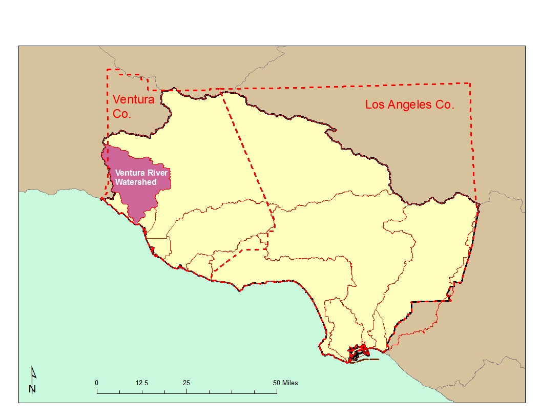
The Ventura River and its tributaries drain a coastal watershed in western Ventura County. The watershed covers a fan-shaped area of 235 square miles, which is situated within the western Transverse Ranges (the only major east-west mountain ranges in the continental U.S.). From the upper slopes of the Transverse Ranges, the surface water system in the Ventura River watershed generally flows in a southerly direction to an estuary, located at the mouth of the Ventura River. Groundwater basins composed of alluvial aquifers deposited along the surface water system, are highly interconnected with the surface water system and are quickly recharged or depleted, according to surface flow conditions. Topography in the watershed is rugged and as a result, the surface waters that drain the watershed have very steep gradients, ranging from 40 feet per mile at the mouth to 150 feet per mile at the headwaters.
 Precipitation varies widely in the watershed. Most occurs as rainfall during just a few storms, between November and March. Summer and fall months are typically dry. Although snow occurs at higher elevations, melting snowpack does not sustain significant runoff in warmer months. The erratic weather pattern, coupled with the steep gradients throughout most of the watershed, result in high flow velocities with most runoff reaching the ocean.
Water Quality Problems and Issues
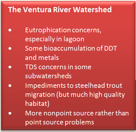
The majority of water quality problems involve eutrophication (excessive nutrients and effects), especially in the estuary/lagoon. A large 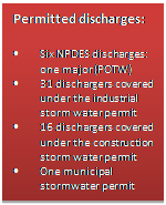 storm drain enters the river near the estuary and homeless persons live in and frequent the river bed. Sediment in the estuary, however, appears relatively uncontaminated. In some subwatersheds, high TDS concen- trations impair the use of water for agriculture. The watershed's water quality problems are, for the most part, nonpoint source-related. There have also been incidents of releases of toxic materials into storm drains entering the lower river.
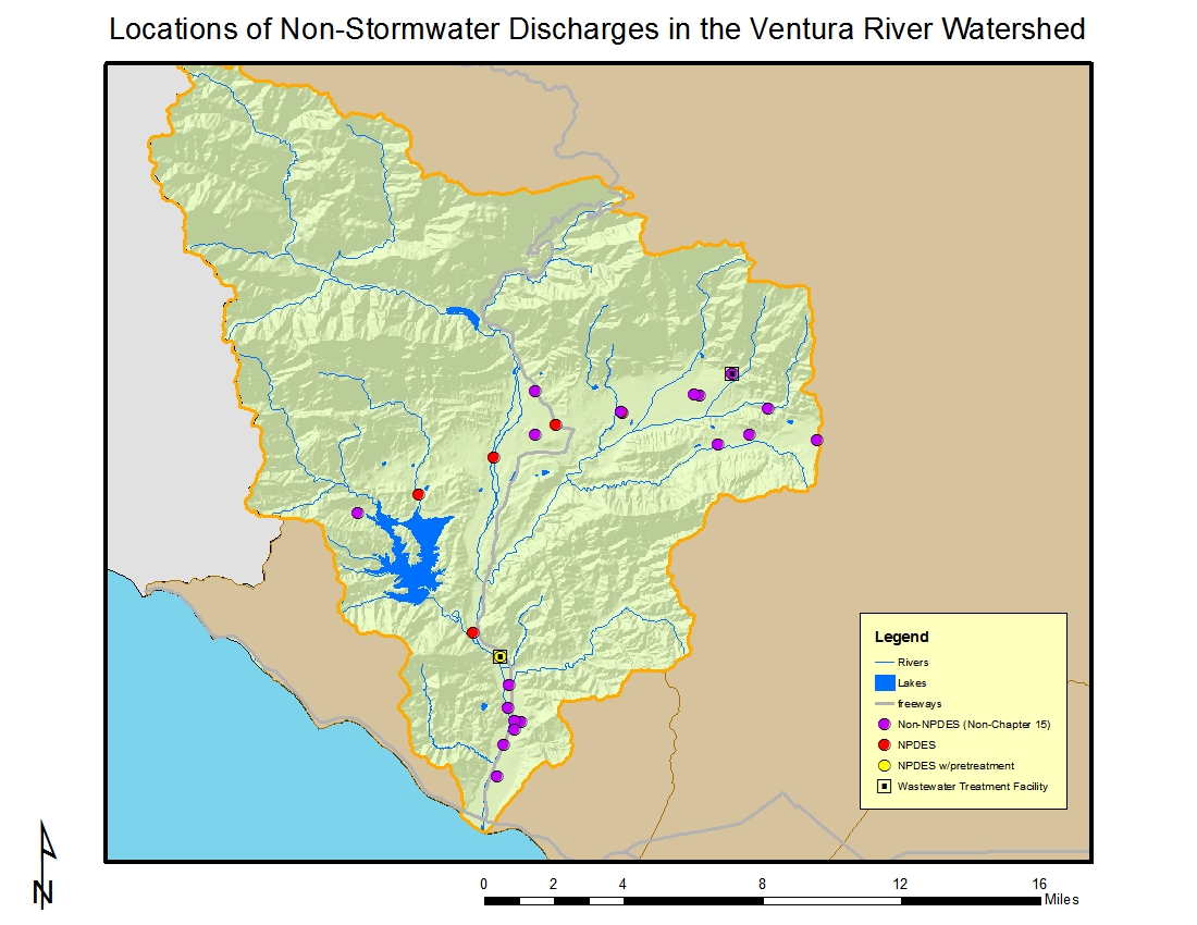
There is only one major discharger, a small POTW discharging to the lower river. For much of the year, the facility's effluent can make up two-thirds of the total river flow in that stretch.
The locations of facilities with discharges to surface water or to the ground (other than those covered by general industrial or construction stormwater permits) are shown in the figure above.

Of the 31 dischargers enrolled under the general industrial storm water permit in the watershed, the majority are in the city of Ventura. Wholesale trade-durable goods, trucking and warehousing, and food and kindred products (including wineries) are most prominently represented based on their Standard Industrial Classification (SIC) codes. Most of the facilities are less than ten acres in size. The locations of facilities with discharges covered by the general industrial stormwater permit are shown in the figure to the right.
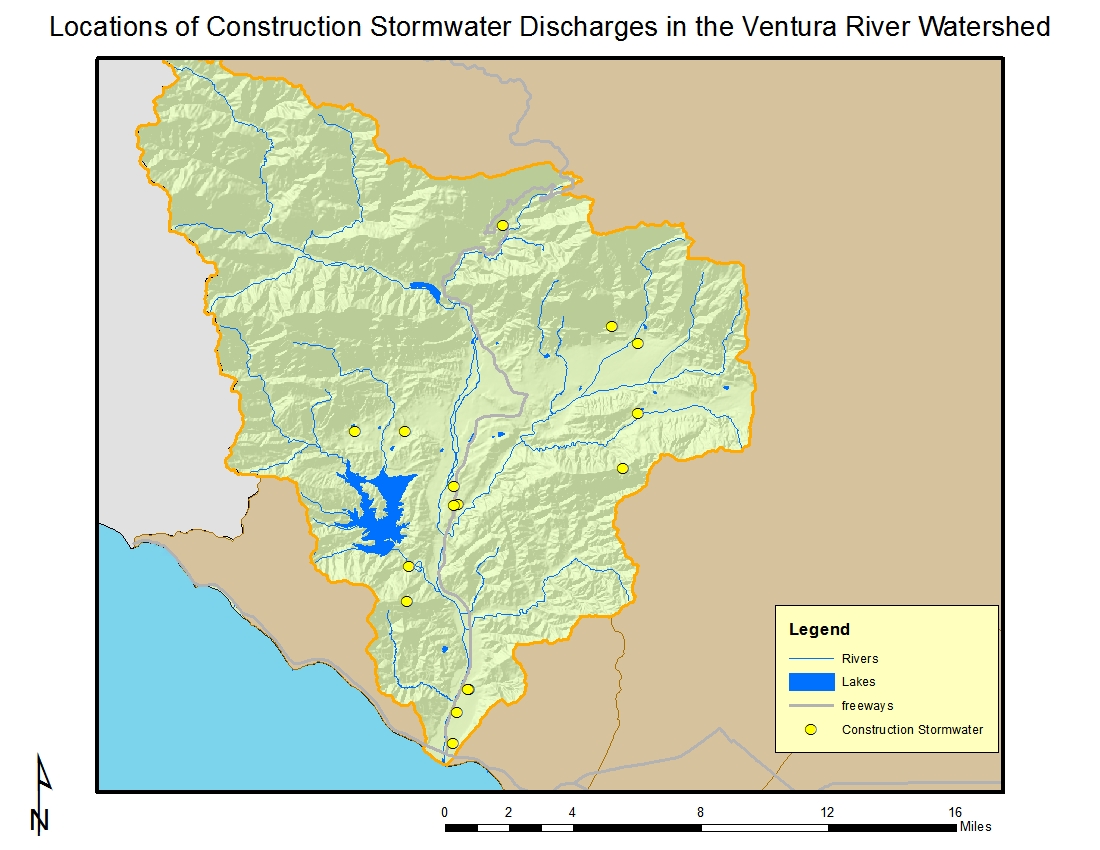
About one-half of the 16 dischargers under the general construction storm water permit are on residential sites shown in the map below; most of the sites are 5 acres or greater in size and range up to 100 acres.
Click on the link for a complete list of permits in the watershed.
Water diversions, dams, and groundwater pumping also are thought to limit surface water resources needed to support a high quality fishery. Reduced water supplies affect water quality and thus beneficial uses, particularly with regards to the endangered steelhead trout (steelhead trout are known to utilize the River and some of its tributaries historically supported annual steelhead runs of 5000 – 6000 adults). Removal of the Matilija Dam in the upper watershed is a high priority as a result.
Regional Board Actions to Address Impairments
A number of Regional Board programs and actions are in place to address the water quality impairments noted earlier.
Total Maximum Daily Loads (TMDLs) have been developed (as required by the Clean Water Act) for m
any of the impairments in the watershed. The TMDL is a number that represents the assimilative capacity of a receiving water to absorb a pollutant and is the sum of the individual wasteload allocations for point sources, load allocations for nonpoint sources plus an allotment for natural background loading, and a margin of safety. TMDLs can be expressed in terms of mass per time (the traditional approach) or in other ways such as toxicity or a percentage reduction or other appropriate measure relating to a water quality objective. A TMDL is implemented by reallocating the total allowable pollution among the different pollutant sources (through the permitting process or other regulatory means) to ensure that the water quality objectives are achieved. TMDLs in effect in all or parts of the watershed include those for nutrients and trash. The effects of water diversions and pumping are also being addressed throught he nutrient TMDL. Additional information on these TMDLs may be found at https://www.waterboards.ca.gov/losangeles/water_issues/programs/tmdl/.
A number of TMDLs contain load allocations assigned to irrigated agriculture. The Regional Board adopted a conditional waiver for discharges from irrigated lands (see https://www.waterboards.ca.gov/losangeles/water_issues/programs/tmdl/waivers/index.shtml) which requires agricultural interests to monitor and implement various best management practices as needed to improve the quality of runoff from irrigated lands. This can be accomplished by growers either individually or through joining a group effort; in the Ventura River Watershed they may join the Ventura County Agriculture Irrigated Lands Group (VCAILG). More information on VCAILG may be found on the Farm Bureau of Ventura County’s website at http://www.farmbureauvc.com/water_quality.html.
Storm water (wet weather) and non-storm water (dry weather) discharges from the municipal separate storm sewer systems (MS4), or storm drain system, within Ventura County are addressed by an NPDES Permit issued to the Ventura County Watershed Protection District (as the Principal Permittee), County of Ventura, and the incorporated cities within. The permit effectively prohibits non-storm discharges into the MS4 and receiving waters with certain exceptions. It also requires that treatment control BMPs be designed to meet certain performance criteria, that each Permittee implement programs and measures to comply with the TMDLs’ waste load allocations for the MS4 specified in the permit, and that regular inspections of various types of commercial facilities be undertaken. A monitoring program must also be implemented. More information about this permit may be found at https://www.waterboards.ca.gov/losangeles/water_issues/programs/stormwater/municipal/index.shtml#ventura. Results from water quality monitoring may be found at http://www.vcstormwater.org/apps/stormwater/.
Activities Led by Watershed Stakeholders
Stakeholders within the area under the jurisdiction of the Los Angeles Regional Board have formed several long-range water planning groups and have developed Integrated Regional Water Management (IRWM) Plans under Propositions 50 and 84. These Plans address the future water needs of each IRWM Region in terms of reliability of the water supply, improvement to water quality (including implementing TMDLs), increases in habitat and open space (additionally serving as areas for recharge of stormwater), and replacement of water-related infrastructure as needed. They also propose projects to help implement the Plan’s goals; applicants may pursue funding through a variety of sources including grant funding available through bond programs.
The Ventura River Watershed Council originally was formed to aid the Trust for Public Land in development of a lower river parkway. It has become a formal part of the IRWM process, led by a Department of Conservation-funded watershed coordinator, as one of three watershed groups in the Watersheds Coalition for Ventura County IRWM. A watershed management plan is also being developed. More information about the watershed council can be found on their website at http://www.venturawatershed.org. Additional information about IRWM planning in Ventura County can be found at http://www.watershedscoalition.org .
The U.S. Army Corps of Engineers, Ventura County Watershed Protection District, U.S. Bureau of Reclamation, and other agencies and entities began convening in 2000 to begin discussions on the possible removal of Matilija Dam as part of an ecosystem restoration. An USACE and VCFCD sponsored ecosystem restoration feasibility study was completed in summer 2004 and a favored alternative is being pursued. More information may be found at http://www.matilijadam.org/.
In 2011, study was conducted in the Ventura County coastal plain entitled “Historical Ecology of the lower Santa Clara River, Ventura River, and Oxnard Plain: an analysis of terrestrial, riverine, and coastal habitats” that is available for download at ftp://ftp.sccwrp.org/pub/download/DOCUMENTS/TechnicalReports/662_VenturaCo_HistoricalEcology.pdf. The study indicated that the flow patterns of today which features alternating sections of river with rising or sinking groundwater and extreme variations in flow overall was also an historical pattern.
The Matilija Coalition is a local group committed to removal of Matilija Dam and subsequent ecosystem restoration. More information about the group may be found at http://www.matilija-coalition.org/ .