 Watershed Description
SANTA MONICA BAY WMA
Watershed Description
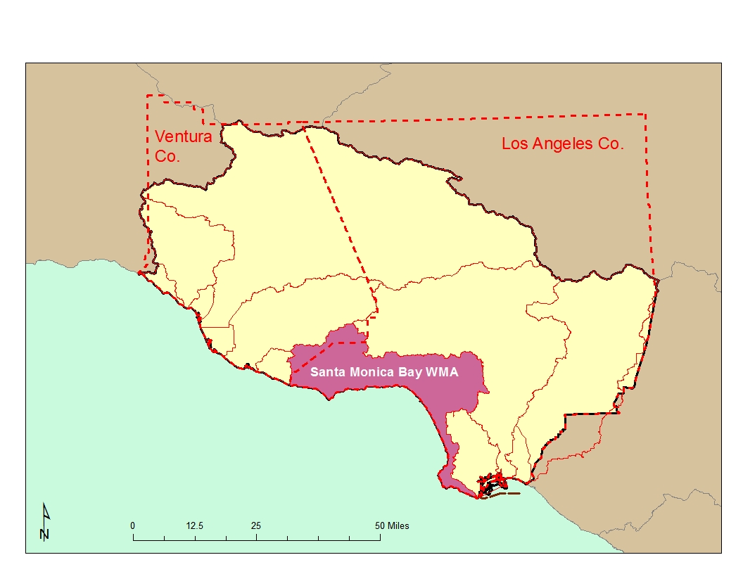
The Santa Monica Bay Watershed Management Area (WMA), which encompasses an area of 414 square miles, is quite diverse. Its borders reach from the crest of the Santa Monica Mountains on the north and from the Ventura-Los Angeles County line to downtown Los Angeles. From there it extends south and west across the Los Angeles plain to include the area east of Ballona Creek and north of the Baldwin Hills. South of Ballona Creek the natural drainage area is a narrow strip of wetlands between Playa del Rey and Palos Verdes. The WMA includes several watersheds, the two largest being Malibu Creek to the north (west) and Ballona Creek to the south. The Malibu Creek area contains mostly undeveloped mountain areas, large acreage residential properties and many natural stream reaches while Ballona Creek is predominantly channelized, and highly developed with both residential and commercial properties.
As a nationally significant water body, Santa Monica Bay was included in the National Estuary Program in 1989. It has been extensively studied by the Santa Monica Bay Restoration Project (now the Santa Monica Bay Restoration Commission or SMBRC) and a watershed plan was developed in 1995. The Santa Monica Bay Watershed Commission was established in 2002 to oversee implementation of the Plan.
 Water Quality Problems and Issues
Though relatively small in its size compared with watersheds in other parts of the country, the Santa Monica Bay WMA embraces a high diversity in geological and hydrological characteristics, habitat features, and human activities. Almost every beneficial use defined in the Basin Plan is identified in water bodies somewhere in the WMA.
Existing and potential beneficial use impairment problems in the watershed fall into two major categories: human health risk, and natural habitat degradation. The former are issues primarily associated with recreational uses of the Santa Monica Bay. The latter are issues associated with terrestrial, aquatic, and marine environments. Pollutant loadings that originate from human ![Text Box: Permitted discharges: • 182 NPDES discharges including: nine major NPDES permit discharges (three POTWs [two direct ocean discharges], one refinery, and three generating stations) • 169 dischargers covered under general permits • 85 dischargers covered by an industrial storm water permit • 192 dischargers covered by the construction storm water permit • Coverage by several municipal stormwater watershed and enhanced watershed management plan permit groups](images/summary_clip_image004.PNG) activities are common causes of both human health risks and habitat degradation. A considerable amount of water quality data are available for the WMA on the California Environmental Data Exchange Network at https://ceden.waterboards.ca.gov and on the My Water Quality web portal at http://www.mywaterquality.ca.gov/index.shtml.
activities are common causes of both human health risks and habitat degradation. A considerable amount of water quality data are available for the WMA on the California Environmental Data Exchange Network at https://ceden.waterboards.ca.gov and on the My Water Quality web portal at http://www.mywaterquality.ca.gov/index.shtml.
Of the major NPDES dischargers in the Santa Monica Bay WMA, the three POTWs (particularly the two direct ocean discharges) are the largest point source contributors of pollutant loads to Santa Monica Bay. Pollutants from the minor discharges have been estimated to contribute less than two percent of the total pollutant loads being discharged to the Bay.
The locations of facilities with discharges to surface water or to the ground (other than those covered by general industrial or construction stormwater permits) are shown in the following figure. Click on the link to obtain a complete list of permitted discharges. Major NPDES discharges are from either POTWs with a yearly average flow of over 0.5 MGD, from an industrial source with a yearly average flow of over 0.1 MGD, or are those discharges with lesser flows but with potential acute or adverse environmental impacts to surface waters. 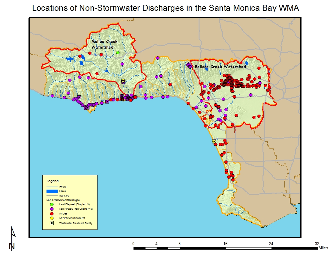 Minor NPDES discharges are all other discharges to surface waters that are not categorized as a Major. Minor discharges may be covered by general NPDES permits, which are issued administratively, for those that meet the conditions specified by the particular general permit. Non-Chapter 15 discharges are those to land or groundwater such as commercial septic systems or percolation ponds that are covered by Waste Discharge Requirements, a State permitting activity. Chapter 15 discharges generally relate to land disposal (landfills) under Chapter 15 of the California Code of Regulations, again an exclusively State permitting activity.
A majority of the 182 NPDES permitted facilities in the WMA discharge to Ballona Creek and many are located along Wilshire Boulevard. 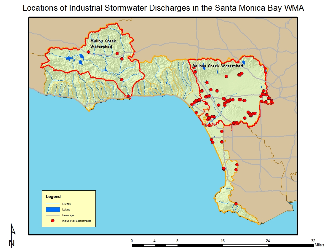
Of the 85 dischargers enrolled under the general industrial storm water permit in the watershed, the largest numbers are located in the cities of Los Angeles and Santa Monica, and are within the Ballona Creek Watershed. Electric, gas and sanitary services; local and interurban passenger transit; and fabricated metal products are a large component of these businesses based on their Standard Industrial Classification (SIC) code. The locations of facilities with discharges covered by the general industrial stormwater permit are shown in the figure to the left.
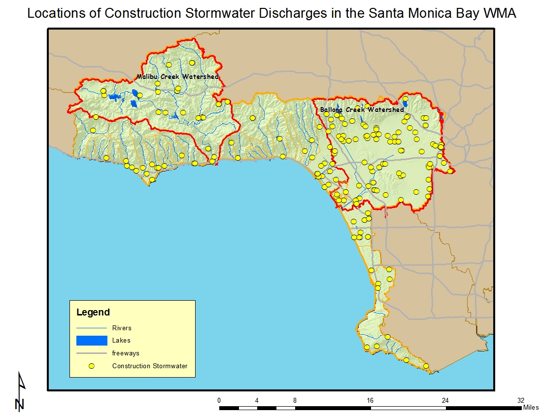
There are a total of 192 construction sites enrolled under the general construction storm water permit as shown in the figure below; about half of the number enrolled in 2007 during the last WMI Chapter update. Many of these sites are in the Malibu Creek and Ballona Creek Watersheds. There are about twice as many residential as commercial sites under the permit with residential sites primarily located in the more rural areas of the WMA and commercial sites located in the more urban areas. About one-half of the sites are five acres or larger; about ten sites are over 100 acres in size.
 A considerable number of monitoring programs have been implemented in the Santa Monica Bay WMA, particularly over the last twenty years. Sampling efforts tend to center around assessing urban runoff effects in along the coastline and at areas surrounding POTWs’ ocean outfalls. Four statewide monitoring programs, State Mussel Watch, Bay Protecton and Toxic Cleanup, Coatal Fish Cotamiation Program and Txic Substances Monitoring, had focused on biological measurements as well. More recently, the State’s Surface Water Ambient Monitoring Program has also collected chemical and biological data. Also, Bight-wide monitoring has included the coastal waters and ocean areas off of the WMA.
The data from these programs indicate that in general the open coastline is much cleaner than the Bay's enclosed waters, except with regards to DDT and PCBs on the Palos Verdes Shelf which is listed as a Superfund site by U.S. EPA. Marina del Rey Harbor has elevated sediment concentrations of DDT, PCB, copper, mercury, nickel, lead, zinc and chlordane, and sediment toxicity; Ballona Creek Entrance Channel is listed as impaired due to sediment concentrations of DDT, zinc, lead, chlordane, dieldrin, and chlorpyrifos, and sediment toxicity. The small coastal streams draining from the Santa Monica Mountains into the bay, as well as Ballona Creek, were sampled by SWAMP in 2003-2004. Nutrient problems were found at a number of drainages and many sites exhibited single sample exceedances of bacteria indicators. Metals generally did not exceed water quality objectives. Water toxicity was found at a few sites; the Index of Biological Integrity scores for benthic invertebrate health ranged from good to very poor.
Urbanization has had a significant impact on the riparian and wetland resources of the watershed, primarily through filling, alteration of flows, and decrease in water quality. It is estimated that 95% of the historic wetlands of the Santa Monica Bay WMA have been destroyed, with the remaining wetlands significantly degraded.
Although groundwater accounts for only a limited portion of the Santa Monica Bay WMA's supply of fresh water, the general quality of groundwater in the watershed has degraded from background levels.
Greater Santa Monica Bay
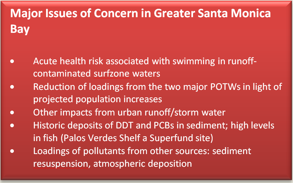 Santa Monica Bay is heavily used for fishing, swimming, surfing, diving etc., activities classified as water contact recreation (REC-1). However, there is an acute health risk associated with swimming in runoff-contaminated surfzone waters, and chronic (cancer) risk associated with consumption of certain sport fish species in areas impacted by DDT and PCB contamination>One of the impacts in marine habitats is sediment contamination and damage to marine life that the contaminants cause when they are released from the sediment (through natural fluctuations or through disturbance of the sediment) into the food chain. Organic compounds such as DDT, PCBs, polycyclic aromatic hydrocarbons (PAHs), and chlordane are found in sediments in concentrations that are harmful to marine organisms at various locations in the Bay. Also found in Bay sediments are heavy metals such as cadmium, copper, chromium, nickel, silver, zinc, and lead. The major historic sources of sediment contamination have been wastewater treatment facilities; thus the accumulations are highest near treatment plant outfalls off of Palos Verdes and Playa del Rey. Bioaccumulation of DDT in white croaker, Dover sole, and California brown pelicans are well-known examples of the impacts caused by sediment contamination. Prior to the 1980s, high concentrations of DDT were found in muscle tissues of these organisms. DDT in these organisms was implicated in fin erosion and other diseases in fish as well as eggshell thinning and subsequent species decline in the California brown pelican.
Malibu Creek Watershed
The most recent Water Quality Assessment Report finds water quality in some streams within the Malibu Creek Watershed is impaired by nutrients and their effects, coliform and their effects, trash, and, in some instances, metals. While natural sources contribute, nonpoint source pollution from human activities is implicated including ill-placed or malfunctioning septic systems and runoff from horse corrals. Nutrient inputs are also contributed by urban runoff and the POTW which discharges tertiary-treated effluent into the Creek about five miles upstream of Malibu Lagoon; a nutrient TMDL has been developed for the watershed.
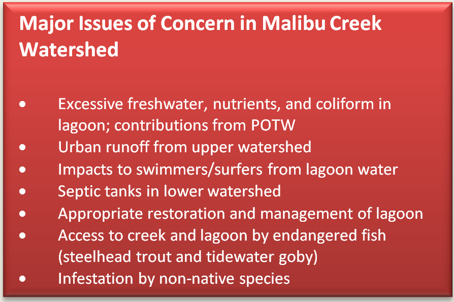 Historically, the Lagoon was much larger than its current day size. Although the flow dynamics of the Creek as well as the ocean's influence on the Lagoon in the past can only be extrapolated, it is likely Creek flow was much less than today during the dry season, partially due to increased imported water demands upstream. Marine influence may have dominated, keeping the lagoon entrance open much of the year as occurs in the larger Mugu Lagoon to the north. An open Lagoon would have facilitated migration of the now endangered steelhead trout. And though continual Creek flow was likely less, more of the watershed was available for the trouts' use, at least prior to the construction of Rindge Dam in the 1920's. Most important, during the dry season there would be access to deep shaded pools in many parts of the watershed where the fish could mature until rain created the flows needed to reach the ocean.
Today, the flow regime is quite different and now a major issue of concern. Both increased urban runoff from the more developed upper watershed and discharges from the POTW have increased baseline flows. However, the POTW which discharges to Malibu Creek is under a discharge prohibition starting each April 15 through November 15 of each year, except during times of plant upset, storm events, or the existence of minimal streamflow conditions that require flow augmentation in Malibu Creek to sustain endangered species.
The lagoon size is much reduced from historic times and it remains closed much of the year except for during the winter when ocean influences breach the sandbar and Creek flows help maintain the opening. This had led to decreasing salinity or, at times, greatly fluctuating salinity. This also leads to elevated groundwater levels adjacent to the lagoon, which affects the function of septic system leachfields in the area. Additionally, surfing and swimming is popular off the beaches in the immediate area and there is considerable concern over contaminated Lagoon water reaching these people. A recently completed restoration of the lagoon is intended to correct many of these problems.
Riparian habitats throughout the watershed have been adversely impacted by infestation of non-native species. Major invasive plant species of concern include Arundo, castor bean, pampas grass, fennel, tree tobacco, and tree of heaven. Major invasive animal species of concern include mudsnail and crayfish.
Several man-made structures such as a dam and culverts exist along the Creek and its tributaries and are barriers to steelhead trout migration. The largest such barrier on the Creek is Rindge Dam. Some segments of the tributaries have also been channelized in the more developed upper watershed.
Ballona Creek Watershed
The 2010 303(d) list indicates impairment in this watershed due to coliform and its effects such as shellfish harvesting advisories; trash; PCBs and pesticides of historical origin such as DDT, chlordane, and dieldrin, as well as their effects such as sediment toxicity; metals such as lead, silver, arsenic, copper, cadmium, and zinc, as well as their effects such as water column toxicity.
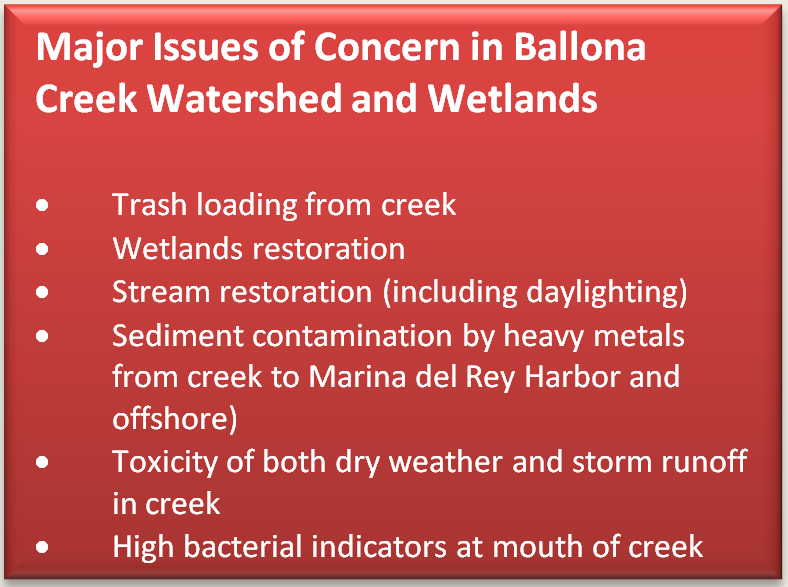 Ballona Creek is completely channelized except for the estuarine portion which has a soft bottom. While at one time it drained into a large wetlands complex, it now has no direct connection to the few wetlands remaining in the area, although tide gates exist in the channel which connects to Ballona Wetlands. However, Ballona Creek may more often affect the nearby wetlands due to wave action moving trash, suspended material and dissolved contaminants from the ocean to the nearby Ballona Wetlands and Marina del Rey Harbor within which complex Ballona Lagoon is located.
The most recent Water Quality Assessment Report indicates impairment in many of these smaller drainages, which discharge directly to the ocean, due to one or several of the following: coliform, ammonia, lead, copper (and toxicity likely associated with metals), trash, and low dissolved oxygen. Due to the frequency of high bacterial indicator levels, warning signs are posted permanently at many of these locations (i.e., storm drain outlets). It should be noted that flows from most of these storm drains have been diverted to the sewer system during dry weather or receive treatment at the point of discharge in order to comply with bacteria Total Maximum Daily Loads (TMDLs).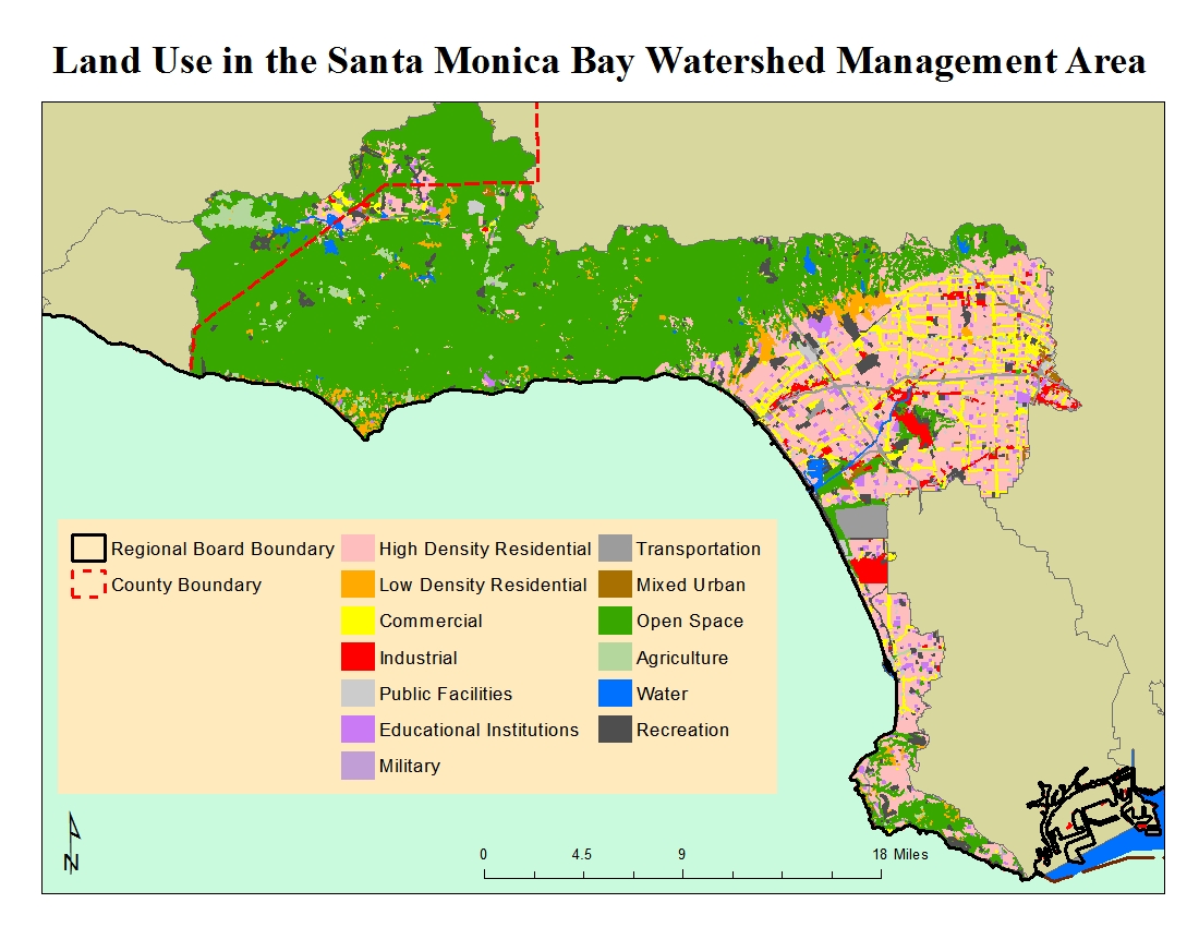
The contrasting nature of land use in the WMA (particularly between the northern (western) and southern portions) can be seen in the figure to the left.
Click on the link to obtain a complete list of water quality impairments.
Regional Board Actions to Address Impairments
A number of Regional Board programs and actions are in place to address the water quality impairments noted earlier.
TMDLs have been developed (as required by the Clean Water Act) for many of the impairments in the watershed. The TMDL is a number that represents the assimilative capacity of a receiving water to absorb a pollutant and is the sum of the individual wasteload allocations for point sources, load allocations for nonpoint sources plus an allotment for natural background loading, and a margin of safety. TMDLs can be expressed in terms of mass per time (the traditional approach) or in other ways such as toxicity or a percentage reduction or other appropriate measure relating to a water quality objective. A TMDL is implemented by reallocating the total allowable pollution among the different pollutant sources (through the permitting process or other regulatory means) to ensure that the water quality objectives are achieved. TMDLs in effect in all or parts of the WMA include those for nutrients, bacteria, metals, pesticides, sediment, invasive exotic vegetation, debris, and trash. The lakes within the WMA are covered by a TMDL established by USEPA. Additional information on these TMDLs may be found at https://www.waterboards.ca.gov/losangeles/water_issues/programs/tmdl/.
The municipal discharges of storm water and non-storm water by the Los Angeles County Flood Control District, the County of Los Angeles, and 84 incorporated cities within the coastal watersheds of Los Angeles County with the exception of the City of Long Beach (hereinafter referred to separately as Permittees and jointly as the Dischargers) from all Municipal Storm Sewer Systems (MS4 – commonly known as the storm drain system) within Los Angeles County with the exception of Long Beach are subject to waste discharge requirements which were adopted in 2012. Both storm water and non-storm water from the MS4 is subject to the permit requirements. The permit effectively prohibits non-storm discharges into the MS4 and receiving waters with certain exceptions. It also requires that treatment control BMPs be designed to meet certain performance criteria, that each Permittee implement programs and measures to comply with the TMDLs’ waste load allocations for the MS4 specified in the permit, and that regular inspections of various types of commercial facilities be undertaken. A monitoring program must also be implemented. Certain provisions of the permit are organized by watershed management area, which is appropriate given the requirements to implement 33 watershed-based TMDLs.
The MS4 Permittees are allowed the flexibility to develop Watershed Management Programs to implement requirements in the permit on a watershed scale through customized strategies, control measures, and BMPs. Participation in a Watershed Management Program is voluntary and allows a Permittee to address the highest watershed priorities. Customized strategies, control measures, and BMPs shall be implemented on a watershed basis, where applicable, through each Permittee’s storm water management program and/or collectively by all participating Permittees through a Watershed Management Program (WMP). Permittees may elect to develop an enhanced Watershed Management Program (EWMP). An EWMP is one that comprehensively evaluates opportunities, within the participating Permittees’ collective jurisdictional area in a Watershed Management Area, for collaboration among Permittees and other partners on multi-benefit regional projects that, wherever feasible, retain all non-storm water runoff and all storm water runoff from the 85th percentile, 24-hour storm event for the drainage areas tributary to the projects, while also achieving other benefits including flood control and water supply, among others. Permittees have formed several EWMP groups within the WMA including: North Santa Monica Bay Coastal Watersheds, Santa Monica Bay Jurisdictions 2 & 3, Beach Cities Watershed Management Group, Malibu Creek Watershed Group, Marina del Rey, Peninsula EWMP Agencies, and Ballona Creek. One permittee (Rolling Hills) is developing an individual WMP. More information about this permit may be found at https://www.waterboards.ca.gov/losangeles/water_issues/programs/stormwater/municipal/index.shtml#los_angeles.
A number of TMDLs contain load allocations assigned to irrigated agriculture. The Regional Board adopted a conditional waiver for discharges from irrigated lands (see https://www.waterboards.ca.gov/losangeles/water_issues/programs/tmdl/waivers/index.shtml) which requires agricultural interests to monitor and implement various best management practices as needed to improve the quality of runoff from irrigated lands. This can be accomplished by growers either individually or through joining a group effort; within Los Angeles County, growers are organized into the Nursery Growers Association Los Angeles County Irrigated Lands Group.(NGA).
The regulatory and permitting issues surrounding the dredging and disposal of often contaminated sediments in marinas is complex. Regional Board staff participates on an interagency team called the Southern California Dredged Material Management Team (SC-DMMT) which was established for the coordinated review of dredging projects and dredging policy issues within the Southern California area, including Los Angeles and Ventura Counties. In Los Angeles County, selected dredging projects are reviewed through the Los Angeles Regional Contaminated Sediment Task Force (CSTF) which was established through legislation in 1997 and with which Regional Board staff also participates. The CSTF developed a long-term management plan for dredging and disposal of contaminated sediments in the Los Angeles area. The CSTF also formulated guidelines for an Advisory Committee to conduct a coordinated project review of dredging activities in the Los Angeles region. Currently, the CSTF Advisory Committee evaluates proposed dredging and disposal projects, including pre-application planning, and evaluation of sampling results.
Activities Led by Watershed Stakeholders
A number of stakeholders began meeting in the late 1980's/early 1990's in the Malibu area which eventually led to the formation of the Malibu Creek Watershed Council (MCWC). Through their efforts, a list of priority issues that need to be resolved was formulated. This led to the development of a Natural Resources Plan for the watershed which was prepared by the U.S. Natural Resources Conservation Service. Separate task forces and subcommittees were formed over the years to address specific issues. The Malibu Creek Watershed Council has more recently evolved into the Santa Monica Mountains Watershed Council.
The MCWC’s Malibu Lagoon Task Force served as an advisory group to development of a lagoon restoration plan funded by the Coastal Conservancy; a copy may be found at http://sites.healthebay.org/assets/pdfdocs/mlhep/issues_mlhep_finalplan.pdf . Implementation of the restoration plan has been completed. A Monitoring Subcommittee continues to meet several times a year to receive updates on studies and issues of interest. A Malibu Creek Ecosystem Restoration Feasibility Study is also underway. The U.S. Army Corps of Engineers and California Department of Parks and Recreation are the major partners in this effort which is evaluating, among other options, the feasibility of restoring the ecosystem through removal of Rindge Dam. More information about both the Malibu Creek and Santa Monica Mountains Watersheds Councils may be found at http://www.rcdsmm.org/malibucreekwatershed. Information about the restoration feasibility study may be found at http://www.spl.usace.army.mil/Missions/CivilWorks/ProjectsStudies/MalibuCreekStudy.aspx.
The Santa Monica Bay Restoration Project was formed in 1989 under the National Estuary Program; it was charged with assessing the Bay's problems, developing solutions, and identifying implementation procedures. It eventually evolved into the Santa Monica Bay Restoration Commission (SMBRC) which was established by an act of the California Legislature in 2002 to monitor, assess, coordinate and advise the activities of state programs and oversee funding that affects the beneficial uses, restoration and enhancement of Santa Monica Bay and its watersheds. The Watershed Advisory Council serves as an advisory body to the Governing Board of the SMBRC while the Technical Advisory Committee ensures the SMBRC has the necessary scientific and technical information upon which to base its decision-making. A Bay Restoration Plan was developed, and most recently updated in 2008, and is in the process of being implemented. More information about the SMBRC may be found at their website http://www.smbrc.ca.gov/ .
In 2006, the SMBRC developed a Comprehensive Monitoring Programwhich lays out new monitoring designs for five major habitat types within the Bay. Each includes a core motivating question, a number of related objectives, specific monitoring approaches, indicators, and data products, and sampling designs detailing number and locations of stations, sampling frequency, and measurements to be collected. The Program incorporates key monitoring efforts that extend from the outer Bay to the high tide line along the shore. It is intended to complement other efforts, such as TMDLs, that link land and marine environments. The five major habitat (or ecosystem) types covered in the Monitoring Program are: pelagic ecosystem, soft bottom ecosystem, hard bottom ecosystem, rocky and sandy intertidal, and wetlands. The Monitoring Program also includes an implementation plan with a detailed schedule, cost estimates for individual Program elements, and recommendations on the Program’s management structure, including data management and assessment strategies.
The Topanga Watershed Committee was formed in 1998 as a followup to previous a community group working on developing alternatives to traditional flood control measures. Their focus expanded to include general watershed management and protection activities as well as volunteer monitoring. Work was also completed to define the extent of restoration feasible to Topanga Lagoon. A watershed management plan was finalized in 2002. Watershed residents continue work on implementation of actions identified in the Management Plan. More information about this group may be found at their website http://www.topangacreekwatershedcommittee.org.
The Ballona Creek Watershed Task Force was formed in 2000 as a stakeholder group addressing water quality and habitat issues in the watershed; it also assisted in development of the Ballona Creek Watershed Management Plan which can be found at http://www.ladpw.org/wmd/watershed/bc. The Los Angeles County Department of Public Works received grant funds in 2001 to develop the Watershed Management Plan. This work was completed in 2004. Although the greater Santa Monica Bay has a restoration plan, this subwatershed with its many urban impacts needs special attention. Since the Creek has also been shown to impact the nearshore environment of Santa Monica Bay, additional benefits will result.
The State Coastal Conservancy in partnership with the California Department of Fish and Wildlife, State Lands Commission, and Santa Monica Bay Restoration Commission is developing a restoration plan for Ballona Wetlands known as the Ballona Wetlands Restoration Project. More information about this work may be found at http://www.santamonicabay.org/ballonarestoration.html . Also on the website is a link to an historical ecology study of the wetlands which may help with planning the restoration.
Stakeholders within the area under the jurisdiction of the Los Angeles Regional Board have formed several long-range water planning groups and have developed Integrated Regional Water Management (IRWM) Plans under Propositions 50 and 84. These Plans address the future water needs of each IRWM Region in terms of reliability of the water supply, improvement to water quality (including implementing TMDLs), increases in habitat and open space (additionally serving as areas for recharge of stormwater), and replacement of water-related infrastructure as needed. They also propose projects to help implement the Plan’s goals; applicants may pursue funding through a variety of sources including grant funding available through bond programs.
Stakeholders in a large portion of Los Angeles County joined together to develop the Integrated Regional Water Management (IRWM) Plan for Greater Los Angeles County (GLAC). Parts of two subregions of the GLAC fall within the Santa Monica Bay WMA. The website for the group is http://www.lawaterplan.org.