MISCELLANEOUS VENTURA COASTAL WMA
Watershed Description
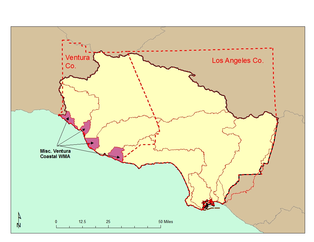
The WMA is composed of four separate coastal drainage areas located between the Regional boundary, the Ventura River, Santa Clara River, and Calleguas Creek Watersheds, as well as, the Santa Monica Bay WMA. The drainage areas are typified by small coastal streams, wetlands, or marinas/urban centers.
Channel Islands Harbor: Channels Islands Harbor is located south of the Santa Clara River and is in the immediate vicinity of considerable residential development and some agricultural land. The Southern California Edison inlet canal to the Ormond Beach Generating Station is located at the north end of the harbor. The harbor is home to many recreational boats and two boatyards.
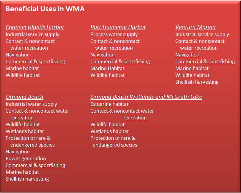 Port Hueneme Harbor: Port Hueneme is a medium-sizeddeepwater harbor located in Ventura County, north of Mugu Lagoon. Part of it was operated by a U.S. Navy Construction Battalion until very recently while the rest of the harbor serves as a commercial port operated by the Oxnard Harbor District. The construction of a majority of the harbor was completed in 1975. The commercial side generally serves ocean-going cargo vessels and oil supply boats; the latter serve the oil platforms in the Santa Barbara Channel. Two endangered bird species may use the harbor, the California Brown Pelican and the California Least Tern.
Ventura Marina: Ventura Marina is a small craft harbor located between the mouths of the Ventura and Santa Clara Rivers. It is home to numerous small boats and two boatyards. The "Ventura Keys" area of the marina is a residential area situated along three canals. The marina is surrounded by agricultural land and a large unlined ditch drains into the Keys area. Since the marina is between the mouths of two rivers which discharge large sediment loads from their relatively undeveloped watersheds, the marina has a constant problem with keeping the entrance channel open.
McGrath Lake: McGrath Lake is a small brackish waterbody located just south of the Santa Clara River. The lake is located partially on State Parks land and partially on privately-owned oilfields in current production. A number of agricultural ditches drain into the lake. A state beach is located off the coastal side of the lake. The habitat around the lake is considered to be quite unique and it is utilized by a large number of overwintering migratory birds.
Open Coastline: A major feature of the coastline north of Mugu Lagoon is Ormond Beach and Ormond Beach Wetlands. There are a number of scenarios under consideration for restoration of these degraded yet valuable wetlands.
Water Quality Problems and Issues
Click on the link to obtain a complete list of water quality impairments. A considerable amount of water quality data are available on the California Environmental Data Exchange Network athttp://www.ceden.org and on the My Water Quality web portal at http://www.mywaterquality.ca.gov/index.shtml.
Channel Islands Harbor: Several beaches in the harbor area are on the 2010 303d list for impairment by indicator bacteria. During the early to mid-1980s, the State Mussel Watch Program (SMWP) found low to intermediate levels of metals and organics except for one especially high accumulation of DDT. Sediment sampling for metals conducted by Regional Board staff in 1988 revealed slightly to moderately elevated levels. Under the Bay Protection and Toxic Cleanup Program (BPTCP), the harbor was listed as site of concern due to DDT and silver sediment concentrations and sediment toxicity. SWAMP sampling in 2006 revealed little to moderate water and sediment toxicity and slightly elevated concentrations of sediment pollutants.
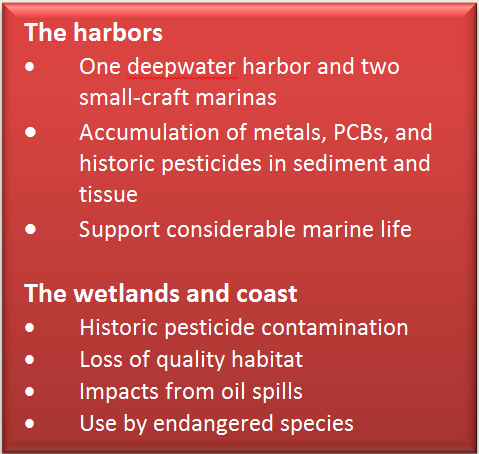 Port Hueneme Harbor: The harbor is on the 2010 303(d) list for DDT and PCBs in tissue. The SMWP found elevated levels of these parameters. An Army CorpsDEIR released in 1985 covering extension of one channel stated that water quality was good. The document also briefly discussed the port's biota which was found to be fairly healthy and typical of southern California harbors. Sediment core samples were collected in 1985 and 1996 as part of a proposed dredge project. Relatively low levels of metals were found and no pesticides were detected. It may well be that flushing is good in the harbor and only locating a station directly next to a source will result in bioaccumulation. The BPTCP found fairly minimal levels of sediment toxicity but the harbor was considered a site of concern under the program due to accumulation of DDT, PCBs, TBT, PAHs, and zinc in mussel tissue. However, more recent monitoring conducted as part of dredging projects have found much lower concentrations of many pollutants. The DDT and PCBs impairments in tissue are being addressed through an action other than a TMDL (dredging).
Ventura Marina: The marina (the Keys area) is on the 2010 303(d) list for coliform problems. The nearby Arundell Barranca is an open drain carrying mostly agricultural runoff which flows into the marina; coliform is found there on a regular basis during sampling. There are currently ongoing discussions concerning the possibility of re-rerouting the barranca away from the marina. The SMWP found moderately elevated levels of metals, DDT, and chlordane in the marina from sampling conducted in the late 1980s; however, it is not listed as a site of concern under the BPTCP. The area around the jetties is listed as impaired for DDT and PCBs.
McGrath Lake: The lake is on the 2010 303(d) list for several legacy pesticides. The BPTCP found varying amounts of sediment toxicity and sediment levels of many pesticides were very high; the lake is listed as a toxic hot spot due to sediment concentrations of DDT, chlordane, dieldrin, toxaphene and endosulfan above sediment quality guidelines. A characterization study revealed the large extent to which the sediment is contaminated, mainly due to runoff from nearby agricultural fields.
Open Coastline: The Oxnard Treatment Plant discharges secondary effluent to the ocean off of Oxnard. An Advanced Water Treatment Facility (AWTF) was built in order to move toward water reclamation. Part of the reclaimed water is proposed for use in a seawater intrusion barrier project to protect the Oxnard Plain ground water basin. The ocean immediately off of the coast was part of Bight ’03, Bight ’98 and the 1994 Southern California Bight Pilot Project. The Ormond Beach Wetlands has been extensively characterized as part of a wetlands restoration planning process being led by the Coastal Conservancy. New samples of water and soil have been collected and data from previous sampling efforts (mostly in relation to a scrap metal facility nearby, Halaco, which is now a USEPA Superfund site) are being assessed for data gaps. Additionally, SWAMP sampled the drains leading into the wetlands during 2006 and found a gradation of sediment and water column toxicity and chemistry with the most pollutants found in the Oxnard Industrial Drain, less in the Huemene Drain, and the least in the J Street Drain.
 Groundwater: The Oxnard Forebay is a prime groundwater recharge area that is impacted by nitrogen discharges, mainly from densely populated communities using septic systems, and agricultural areas.
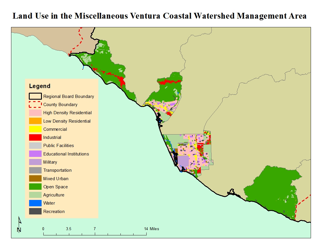
Land use in this WMA trends heavily to either open space or urban uses as shown in the figure to the left.
The locations of facilities with discharges to surface water or to the ground (other than those covered by general industrial or construction stormwater permits) are shown in the figure below. Major NPDES discharges are from either POTWs with a yearly average 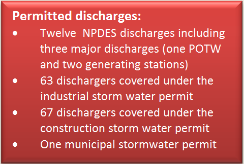 flow of over 0.5 MGD, from an industrial source with a yearly average flow of over 0.1 MGD, or are those discharges with lesser flows but with potential acute or adverse environmental impacts to surface waters. Minor NPDES discharges are all other discharges to surface waters that are not categorized as a Major. Minor discharges may be covered by general NPDES permits, which are issued administratively, for those that meet the conditions specified by the particular general permit. Non-Chapter 15 discharges are those to land or groundwater such as commercial septic systems or percolation ponds that are covered by Waste Discharge Requirements, a State permitting activity. Chapter 15 discharges generally relate to land disposal (landfills) under Chapter 15 of the California Code of Regulations, again an exclusively State permitting activity.
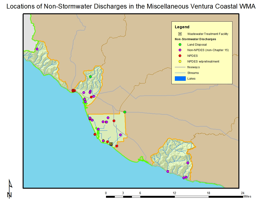 Most of the 12 NPDES permittees in the watershed management area discharge to coastal streams; there two major NPDES discharges, a POTW and a generating station, to the ocean.
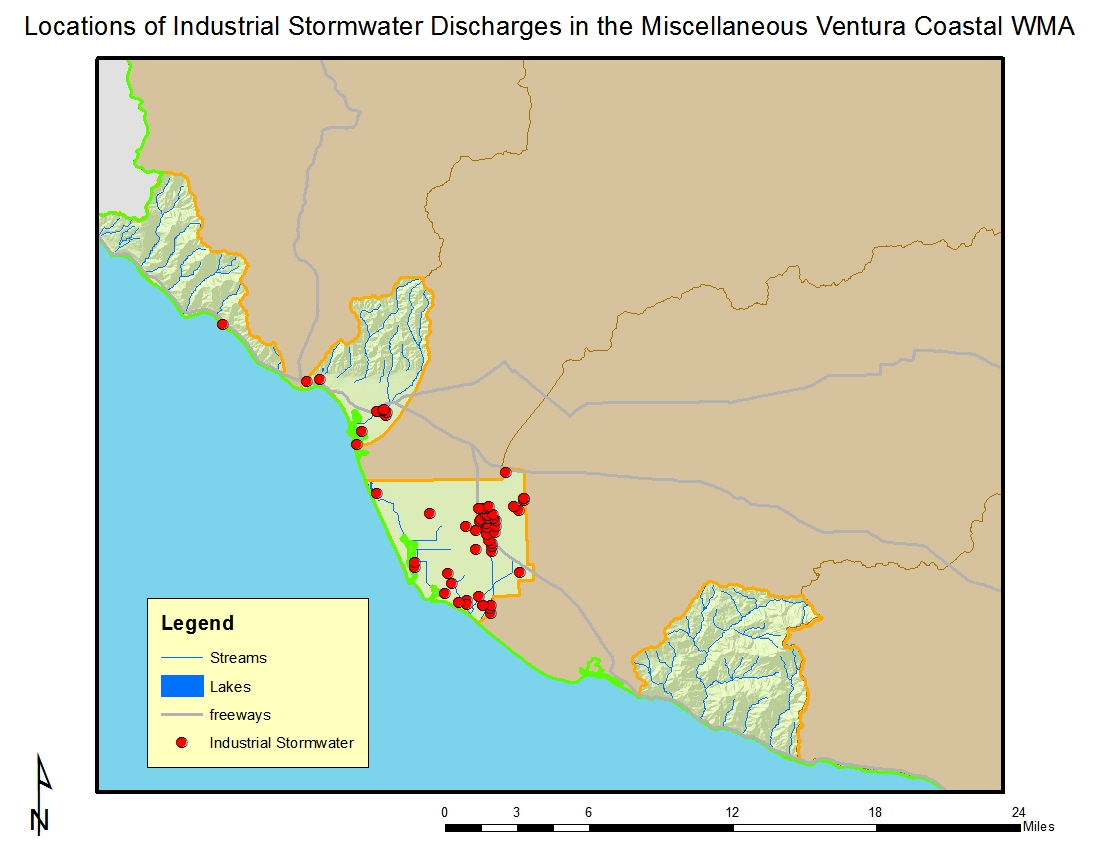 Of the 63 dischargers enrolled under the general industrial storm water permit in the watershed, the majority occur in the city of Oxnard. Many of these businesses are involved with trucking and warehousing, local and interurban passenger transit, food and kindred products, and oil and gas extraction according to their Standard Industrial Classification (SIC) codes. The locations of facilities with discharges covered by the general industrial stormwater permit are shown in the figure to the right
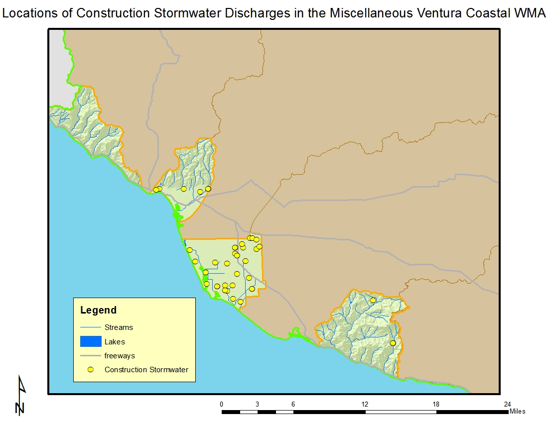
There are 67 construction sites enrolled under the general construction storm water permit on a mix of residential, industrial, and commercial sites primarily in the Oxnard area. About one-half of the sites are five acres or larger in size on up to about 100 acres. The locations of the sites are shown in the figure below.
Click on the link for a complete list of permits in the watershed.
 Regional Board Actions to Address Impairments
A number of Regional Board programs and actions are in place to address the water quality impairments noted earlier.
Total Maximum Daily Loads (TMDLs) have been developed (as required by the Clean Water Act) for many of the impairments in the watershed. The TMDL is a number that represents the assimilative capacity of a receiving water to absorb a pollutant and is the sum of the individualwasteload allocations for point sources, load allocations for nonpoint sources plus an allotment for natural background loading, and a margin of safety. TMDLs can be expressed in terms of mass per time (the traditional approach) or in other ways such as toxicity or a percentage reduction or other appropriate measure relating to a water quality objective. A TMDL is implemented by reallocating the total allowable pollution among the different pollutant sources (through the permitting process or other regulatory means) to ensure that the water quality objectives are achieved. TMDLs in effect include those for bacteria at various harbor beaches, bacteria at McGrath Beach (being addressed through a cleanup and abatement order), and PCBs, pesticides, and sediment toxicity at McGrath Lake. Additional information on these TMDLs may be found at http://www.waterboards.ca.gov/losangeles/water_issues/programs/tmdl/.
A number of TMDLs contain load allocations assigned to irrigated agriculture. The Regional Board adopted a conditional waiver for discharges from irrigated lands (seehttp://www.waterboards.ca.gov/losangeles/water_issues/programs/tmdl/waivers/index.shtml) which requires agricultural interests to monitor and implement various best management practices as needed to improve the quality of runoff from irrigated lands. This can be accomplished by growers either individually or through joining a group effort; in this WMA they may join the Ventura County Agriculture Irrigated Lands Group (VCAILG). More information on VCAILG may be found on the Farm Bureau of Ventura County’s website at http://www.farmbureauvc.com/water_quality.html.
Storm water (wet weather) and non-storm water (dry weather) discharges from the municipal separate storm sewer systems (MS4), or storm drain system, within Ventura County are addressed by an NPDES Permit issued to the Ventura County Watershed Protection District (as the Principal Permittee), County of Ventura, and the incorporated cities within. The permit effectively prohibits non-storm discharges into the MS4 and receiving waters with certain exceptions. It also requires that treatment control BMPs be designed to meet certain performance criteria, that each Permittee implement programs and measures to comply with the TMDLs’ waste load allocations for the MS4 specified in the permit, and that regular inspections of various types of commercial facilities be undertaken. A monitoring program must also be implemented. More information about this permit may be found at http://www.waterboards.ca.gov/losangeles/water_issues/programs/stormwater/municipal/index.shtml#ventura. Results from water quality monitoring may be found at http://www.vcstormwater.org/apps/stormwater/.
The regulatory and permitting issues surrounding the dredging and disposal of often contaminated sediments in marinas is complex. Regional Board staff participates on an interagency team called the Southern California Dredged Material Management Team (SC-DMMT) which was established for the coordinated review of dredging projects and dredging policy issues within the Southern California area, including Los Angeles and Ventura Counties.
The Regional Board undertook a study of septic systems in the Oxnard Forebay 1998; in August 1999 the Board adopted a Basin Plan amendment to prohibit septic systems in the Oxnard Forebay. The amendment immediately prohibited the installation of new septic systems or the expansion of existing septic systems on lot sizes of less than five acres. Discharges from septic systems on lot sizes of less than five acres were required to cease by January 1, 2008.
Activities Led by Watershed Stakeholders
Ormond Beach Task Force The Task Force was formed in 1993 and meets as needed to address issues and projects which may affect the beach and wetlands. Major ongoing activities include work by USEPA to characterize and clean up the Halaco Superfund site adjacent to Ormond Beach Wetlands and wetlands restoration planning being undertaken by the State Coastal Conservancy. The results of studies conducted at the former Halaco site can be found at http://yosemite.epa.gov/r9/sfund/r9sfdocw.nsf/ViewByEPAID/cad009688052. Documents produced for the wetlands restoration planning can be found athttp://scc.ca.gov/2010/01/07/ormond-beach-wetlands-restoration-project/. In 2011, study was conducted in the Ventura County coastal plain entitled “Historical Ecology of the lower Santa Clara River, Ventura River, and Oxnard Plain: an analysis of terrestrial, riverine, and coastal habitats” that is available for download atftp://ftp.sccwrp.org/pub/download/DOCUMENTS/TechnicalReports/662_VenturaCo_HistoricalEcology.pdf. The area covered by the study includes the Ormond Beach Wetlands and provided considerable assistance to the restoration planning effort.