

Gualala Roads Program
Staff of the North Coast Water Board’s Watershed Assessment and Recovery Unit (WARU) are developing the Gualala Roads Assessment Order, a watershed-specific order that will address sediment pollution by requiring the inventory, assessment, and prioritization of sediment-generating roads.
Announcements
Staff Office Hours
North Coast Water Board staff are holding virtual office hours on Thursday,
October 15th to discuss the Gualala Roads Assessment Order. See meeting information below for details. This will be an unstructured meeting time during which members of the community are encouraged to bring any questions, comments, or concerns they may have about the order.
Meeting Information
Date: Thursday, October 15, 2026
Time: 3:00 pm – 4:00 pm
Location: Zoom
Link: https://waterboards.zoom.us/j/84506258213
Meeting ID: 845 0625 8213
Adoption Hearing Moved to February 2027
The North Coast Water Board has changed the date of the adoption hearing for the Gualala Roads Assessment Order. Previous announcements indicated that Order adoption would be proposed at the December 2026 meeting of the North Coast Water Board.
To provide North Coast Water Board staff sufficient time to meaningfully consider the significant volume of public comments received from landowners and other interested parties, the adoption hearing is being moved to February 2027.
Additional information about the February 2027 proposed adoption hearing will be provided when available on this web page, the North Coast Water Board’s Board Meeting page, and to subscribers of the “Gualala River Watershed – TMDL” email list (subscribe here).
Public Review Draft Order
The North Coast Water Board has developed a draft Water Code Section 13267 Informational Order Directing Applicable Landowners in the Gualala River Watershed to Submit Technical Reports Pertaining to the Inventory, Assessment, and Prioritization of Ownership-Wide Road-Related Sediment Discharge Sites (draft Gualala Roads Assessment Order).
The draft Gualala Roads Assessment Order and related attachments were available for public review from Monday, July 13, 2026 through Friday, August 21, 2026.Draft Order and Attachments:
- Staff Summary Report
- Draft Gualala Roads Assessment Order
- Attachment A: Applicable Landowners
- Attachment B: Watershed Map
- Attachment C: Definitions and Acronyms
- Attachment D: Calculation of Estimated Assessment Costs
- Attachment E: Evaluation Methodology
- Attachment F: Annual Status Report Form
- Attachment G: Independent Contractor Certification Form
Technical Reports
Technical reports related to the Gualala River Watershed developed by the Sonoma Resource Conservation District under contract with the North Coast Water Board are available on their website at the address below.
https://sonomarcd.org/programs/water-resources/
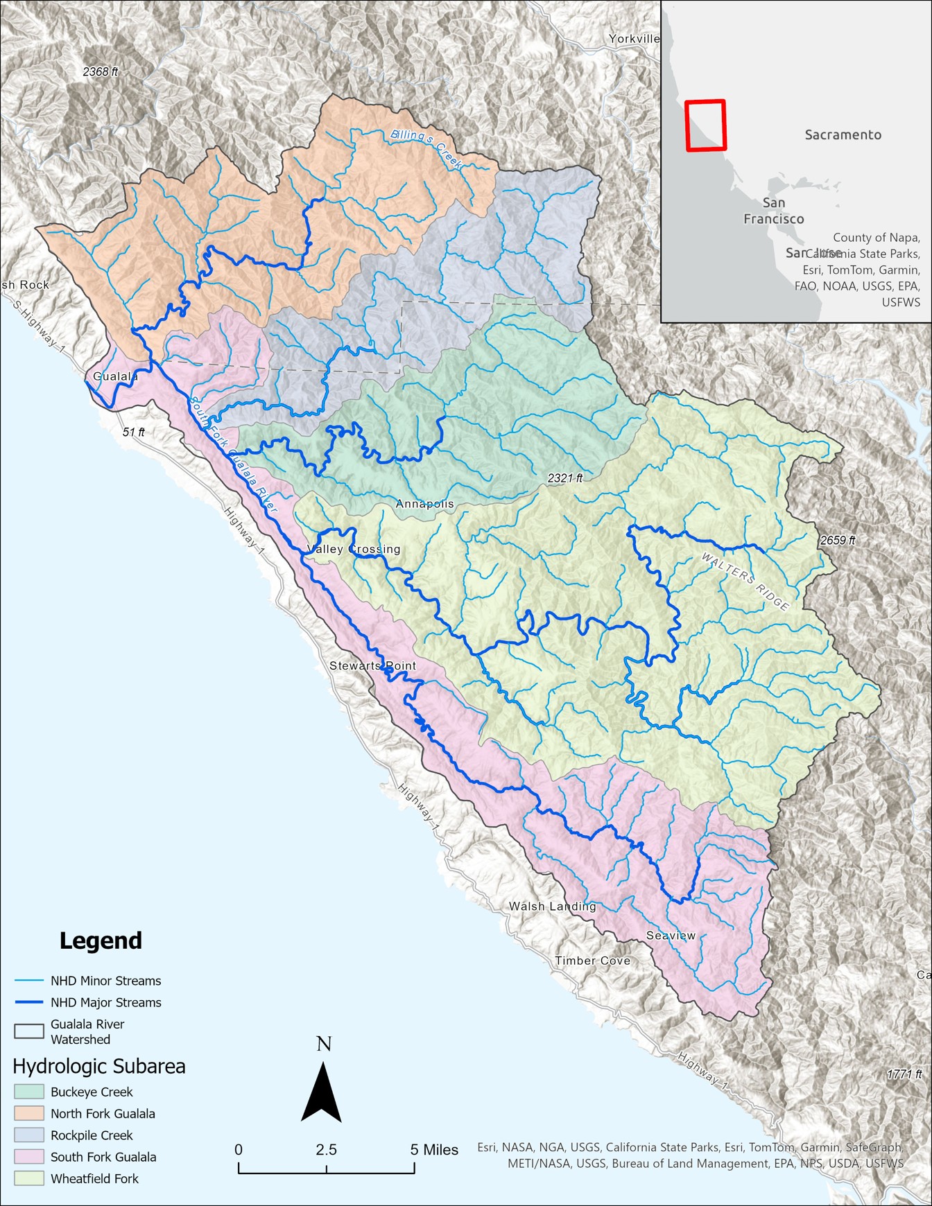
The Gualala River Watershed spans about 300 square miles across Sonoma and Mendocino counties. Its unique elongated shape, influenced by the San Andreas and Tombs Creek faults, supports a diverse ecosystem with forests of redwood and Douglas-fir, and various beneficial uses of water, such as cold water fisheries, recreation, and drinking water. The Gualala River is considered "impaired" under the Clean Water Act due to too much sediment in the water and elevated water temperatures. These conditions are negatively impacting fish like native salmon and trout, affecting their migration, spawning, and early development. Approximately 61% of the sediment entering streams in the Gualala River watershed is from rural roads, which span a length of more than 1,500 miles. To improve the watershed’s health, the amount of sediment coming from these roads must be reduced by almost 90%.
What is the North Coast Water Board’s role in protecting the watershed?
The North Coast Regional Water Quality Control Board, or North Coast Water Board, is the primary California state agency responsible for protecting and improving water quality in streams, rivers, lakes, wetlands, and groundwater in the North Coast. This involves:
- setting water quality standards for waterbodies;
- developing and issuing permits to regulate sources of pollution;
- monitoring and analyzing the health of waterbodies; and
- enforcing environmental regulations.
A Total Maximum Daily Load – a regulatory tool that identifies the amount of a contaminant (e.g., sediment) that a waterbody can receive and still properly function – was developed in 2001 and identifies roads as one of the key sediment sources in the watershed. Part of the Total Maximum Daily Load implementation strategy for the watershed is developing 1) an Action Plan that describes how the Total Maximum Daily Load will be achieved and 2) a permit that requires landowners to reduce the amount of sediment on rural, private roads that can enter waterbodies.
The forthcoming Gualala Roads Permit will be one of several permits that the North Coast Water Board administers in the watershed to prevent and minimize water pollution from land use activities. Other existing water quality permits regulate activities such as forestry management and timber harvest, cannabis cultivation, construction sites and industrial facilities, and may soon include commercial vineyards.
A critical element of controlling sediment discharges from roads is to apply storm-proofing treatments. In their Updated Handbook for Forest, Ranch, and Rural Roads, Pacific Watershed Associates have prepared a list of storm-proofed roads characteristics. That list is reproduced below.
Storm-proofed Stream Crossings:
- All stream crossings have a drainage structure designed for the 100-year flood flow (including woody debris and sediment).
- Stream crossings have no diversion potential (functional critical dips are in place).
- Culvert inlets have low plug potential (trash barriers or deflectors are installed where needed).
- Culverts are installed at the base of the fill and in line with the natural channel.
- Any existing culverts or new emergency overflow culverts that emerge higher in the fill have full round, anchored downspouts that extend to the natural channel.
- Stream crossing culvert outlets are protected from erosion (extend culverts at least 6 feet beyond the base of the fill and use energy dissipation, where needed).
- Culvert inlet, outlet and bottom are open and in sound condition.
- Deep fills (deeper than a backhoe can reach from the roadbed) with undersized culverts or culverts with high plugging potential are fitted with an emergency overflow culvert.
- Bridges have stable, non-eroding abutments and do not significantly restrict 100-year flood flow.
- Stream crossing fills are stable (unstable fills are removed or stabilized).
- Approaching road surfaces and ditches are “disconnected” from streams and stream crossing culverts to the maximum extent feasible using road shaping and road drainage structures.
- Class I (fish-bearing) stream crossings meet State Fish and Wildlife and National Marine Fisheries Service fish passage criteria.
- Decommissioned stream crossings are excavated to exhume the original, stable, stream bed and channel sideslopes, and then stabilized with mulch and vegetation.
Storm-proofed Road and Landing Fills:
- Unstable and potentially unstable road and landing fills that could deliver sediment to a stream are excavated (removed) or structurally stabilized.
- Excavated spoil is placed in locations where eroded material will not enter a stream.
- Excavated spoil is placed where it will not cause a slope failure or landslide.
Storm-proofed Road Surface Drainage:
- Road surfaces and ditches are hydrologically “disconnected” from streams and stream crossing culverts. Road surface runoff is dispersed, rather than collected and concentrated.
- Ditches are drained frequently by functional ditch relief culverts, rolling dips or cross road drains.
- Outflow from ditch relief culverts does not discharge to streams.
- Ditch relief culverts with gullies that deliver to a stream are removed or dewatered.
- Ditches and road surface drainage does not discharge (through culverts, rolling dips or other cross drains) onto active or potential landslides.
- Decommissioned roads have permanent drainage and do not rely on ditches.
- Fine sediment contributions from roads, cutbanks and ditches are minimized by utilizing seasonal closures and installing a variety of surface drainage techniques including berm removal, road surface shaping (outsloping, insloping or crowning), rolling dips, ditch relief culverts, waterbars and other measures to disperse road surface runoff and reduce or eliminate sediment delivery to the stream.
Stay Informed
Interested parties who would like to receive notifications of Gualala Roads Permit project updates can enroll in email list subscriptions – select “Gualala River Watershed - TMDL” from the options provided.
Events
Upcoming
Gualala Roads Assessment Order
Staff Office Hours
Thur, Oct 15, 2026, 3:00 PM – 4:00 PM
Zoom
Gualala Roads Assessment Order
Staff Office Hours
Thu, Sept 3, 2026, 10:00 AM – 12:00 PM
Guerneville Regional Library
14107 Armstrong Woods Rd, Guerneville, CA 95446
Gualala Roads Assessment Order
Staff Office Hours
Thur, Aug 6, 2026, 3:00 PM – 4:00 PM
Zoom
Gualala Roads Assessment Order
Public Review of Draft Order
Wed, July 8, 2026 – Fri, Aug 21, 2026
Gualala Roads Assessment Order
Community Meeting (Hybrid)
Thu, Jun 18, 2026. 10:00 am - 12:00 pm
Lake Sonoma Visitor Center: 3333 Skaggs Springs Rd.,
Geyserville, CA 95441
and Zoom
Gualala Roads Assessment Order
Staff Office Hours
Wed, Apr 29, 2026, 4:00 PM – 5:00 PM
Zoom
Gualala Roads Assessment Order
Community Meeting (virtual)
Tue, Apr 14, 2026 5:00 PM – 7:00 PM
Zoom
Gualala Roads Assessment Order
Community Meeting (in-person)
Thu, Apr 9, 2026 2:00 PM – 4:00 PM
Gualala Point Regional Park Visitor Center, 42401 Coast Hwy 1, Gualala, CA 95445
Gualala Roads Assessment Order
Staff Office Hours (In-person)
Tue, Mar 3, 2026 9:00 AM – 11:00 AM
Coffee & Moore: 6761 Sebastopol Ave, Sebastopol, CA 95472
Gualala Roads Assessment Order
Community Meeting (Hybrid)
Wed, Feb 11, 2026. 10:00 am - 12:00 pm
Lake Sonoma Visitor Center: 3333 Skaggs Springs Rd.,
Geyserville, CA 95441
and Zoom
Gualala Roads Order
Staff Office Hours (Virtual)
Tue, Jan 6, 2026, 5:00 PM – 6:00 PM
Zoom
Gualala Roads Order
Staff Office Hours (Virtual)
Mon, Dec 22, 2025, 3:00 PM – 4:00 PM
Zoom
Gualala Roads Permit
Staff Office Hours (Virtual)
Thu, Sep 18, 2025, 3:30 PM – 4:30 PM
Zoom
Gualala River Sediment TMDL Action Plan
Public Review Period Ends
Mon, Aug 25, 2025
Gualala Roads Permit
Staff Office Hours (Virtual)
Mon, Aug 18, 2025, 4:00 PM – 5:00 PM
Zoom
Gualala Roads Permit
CEQA Scoping Period Ends
Fri, Aug 15, 2025
Gualala River Sediment TMDL Action Plan
Public Workshop
Thu, Aug 14, 2025
5550 Skylane Blvd, Ste. A, Santa Rosa, CA 95403
Gualala Roads Permit:
CEQA Scoping Workshop (In-person)
Thu, Jul 24, 2025, 10:00 AM – 11:00 AM
Gualala Arts Center, 46501 Old Stage Rd, Gualala, CA 95445
Gualala Roads Permit:
Staff Office Hours (In-person)
Wed, Jul 23, 2025, 8:00 AM - 11:00 AM
Gualala Pizza & Bakery, 39225 CA-1, Gualala, CA 95445
Gualala Roads Permit:
CEQA Scoping Workshop (Virtual)
Mon, Jul 21, 2025, 5:30 PM – 6:30 PM
Zoom
Meeting Recording
Gualala Roads Permit:
CEQA Scoping Period Begins
Mon, Jul 14, 2025
Gualala River Sediment TMDL Action Plan:
Public Review Period Begins
Fri, Jul 11, 2025
Gualala Roads Permit
Informational Table at Wildfire Community Preparedness Day Event
Sun, May 4, 2025, 10:00 AM – 1:00 PM
Fort Ross School, 30600 Seaview Rd, Cazadero, CA 95421
Contact
General inbox:
RB1-Gualala@waterboards.ca.gov
Matt Graves, Project Manager
matt.graves@waterboards.ca.gov
Devon Rabellino, Unit Supervisor
devon.rabellino@waterboards.ca.gov
Quarterly Project Status Updates
- August 2026 Project Status Update
- April 2026 Project Status Update
- January 2026 Project Status Update
- July 2025 Project Status Update
- April 2025 Project Status Update
- January 2025 Project Status Update
- October 2024 Project Status Update
- July 2024 Project Status Update
- April 2024 Project Status Update
- January 2024 Project Status Update
- October 2023 Project Status Update
Related Links
- Gualala TMDL web page
- Regionwide Roads Order Development web page (coming soon)
- Rural Roads General Order web page
- 5C County Roads Program web page
- Sediment TMDL Implementation Policy
- Nonpoint Source Policy
- Handbook for Forest, Ranch, and Rural Roads
(Page last updated 10/8/26)
Water is a precious resource in California, and maintaining its quality is of utmost importance to safeguard the health of the public and the environment.
Statewide Campaigns
EPA Water Sense
File an Environmental Complaint
Save Our Water
Flex Alert
Register to Vote

