Coastal Pathogen Source Reduction Strategy
Announcements
On April 2, 2025, the North Coast Regional Water Quality Control Board adopted Resolution R120250010 supporting the submittal of the Coastal Pathogen Source Reduction Strategy (Implementation Plan) to the State Water Resources Control Board (State Water Board) to Include as part of the 2028 California Integrated Report for Clean Water Act 303(d) List and 305(b) Report (Integrated Report).
Background
The 2012 Clean Water Act (CWA) Section 303(d) List of Impaired Waterbodies (Section 303(d) List) identifies six North Coast coastal streams as impaired for the water contact recreation (REC-1) beneficial use, and twelve (12) North Coast ocean beaches as impaired for REC-1 and/or Shellfish Harvesting (SHELL) beneficial use. These streams and beaches have been listed as impaired due to exceedances of the REC-1 and/or SHELL fecal indicator bacteria water quality objective (objective). Additional studies conducted by the North Coast Regional Water Quality Control Board (North Coast Water Board) staff also identified thirteen other coastal streams in the North Coast region that are not identified on the Section 303(d) List, but which have at least one exceedance of the REC1 objective.
The presence of fecal waste material in water is correlated with the potential presence of illness-causing pathogens, such as bacteria, viruses, or protozoa. These organisms can cause illness either through direct contact or incidental water ingestion, impacting REC-1 beneficial use, or through ingestion of contaminated shellfish, impacting SHELL beneficial use.Overview
Under the CWA Section 303(d), the North Coast Water Board is required to establish a Total Maximum Daily Load (TMDL) for those pollutants identified as causing impairment of waters on the 303(d) List. The United State Environmental Protection Agency’s (U.S. EPA) 20222032 Vision for the CWA Section 303(d) Program (EPA Vision) also recognizes the use of alternative plans (including a Category 4b demonstration) in addition to, or in lieu of, TMDLs. The EPA Vision recognizes that certain alternatives may be more immediately beneficial or practicable for restoring water quality, and encourages the most effective approach be applied for restoring water quality.
A Category 4b demonstration documents the manner in which established or planned pollution control requirements are expected to result in the attainment of an applicable objective in a reasonable period of time. If accepted by U.S. EPA, a Category 4b demonstration would result in a determination that a TMDL is not needed to restore supporting conditions for beneficial uses in the waters addressed because alternative mechanisms are expected to do so. U.S. EPA undertakes review and acceptance of Category 4b demonstrations as part of the Integrated Report process.
Consistent with the EPA Vision, the North Coast Water Board staff have developed the Coastal Pathogen Source Reduction Strategy (Implementation Plan) as a Category 4b demonstration. The Implementation Plan identifies existing or planned permit conditions and regulatory authorities to address the controllable anthropogenic (human, dog, cattle) fecal sources that have been identified as sources leading to impairment of REC1 and/or SHELL in certain waterbodies. The Implementation Plan addresses pathogen impairment in six streams and at nine beaches along the North Coast. In addition, although not required as part of a Category 4b demonstration, the Implementation Plan also addresses the need for source control for 13 additional Humboldt County streams currently not on the Section 303(d) List, but where data indicates at least one exceedance of the REC1 bacteria objective as well as evidence of anthropogenic sources of fecal pollution. Three impaired ocean beaches are not addressed in the Implementation Plan as these beaches did not show evidence of anthropogenic fecal sources that could be controlled. Available data collected from these three beaches indicate wildlife (gulls, deer, and elk) as the sources of fecal pollution.
On April 2, 2025, the North Coast Regional Water Quality Control Board adopted Resolution R120250010 supporting the submittal of the Coastal Pathogen Source Reduction Strategy (Implementation Plan) to the State Water Resources Control Board (State Water Board) to Include as part of the 2028 California Integrated Report for Clean Water Act 303(d) List and 305(b) Report (Integrated Report).
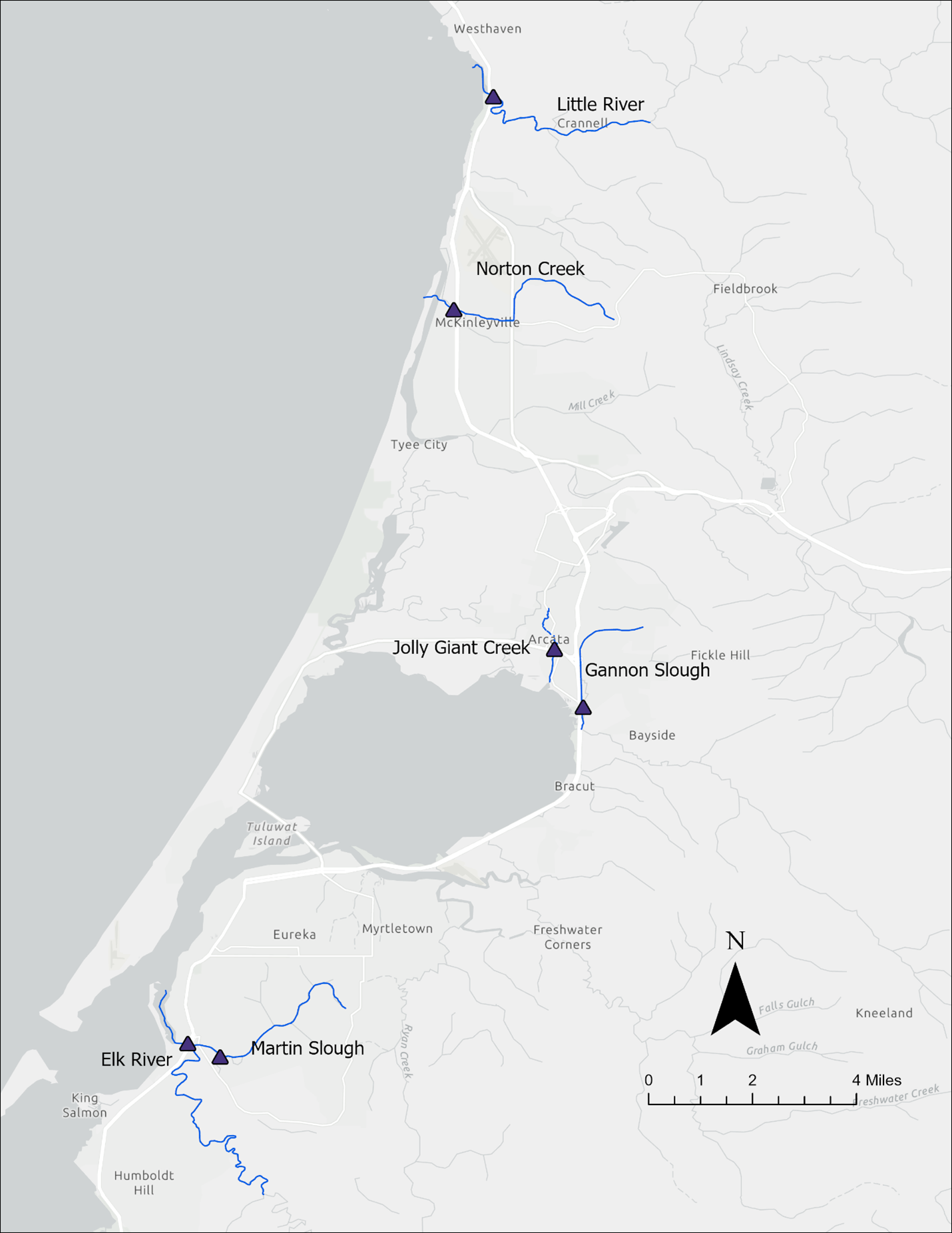
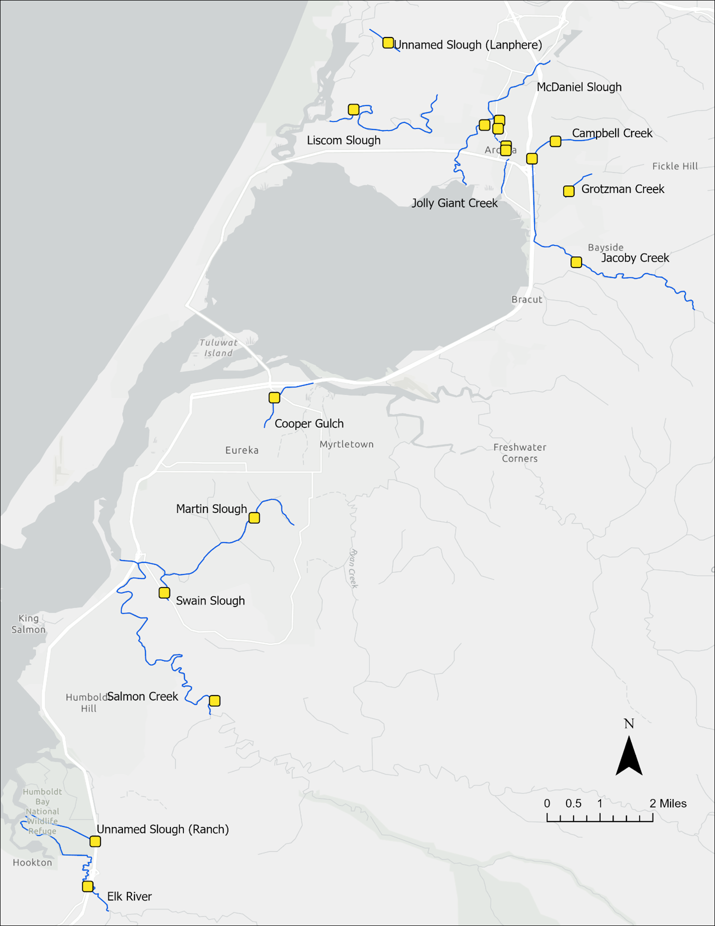
Staff will submit the Implementation Plan as an attachment to the 2028 Integrated Report via the State Water Board. As part of the Integrated Report processes, the Category 4b demonstration will undergo review by State Water Board staff, a period of public review and comment, consideration by the State Water Board for approval, and consideration by U.S. EPA for acceptance. The Integrated Report public review and comment period, including the Implementation Plan, would be anticipated to occur in early 2027, followed by State Water Board adoption of the Integrated Report in 2028 and ultimately submittal to the U.S. EPA for approval later that year.Impaired streams in Humboldt County addressed in the Implementation Plan
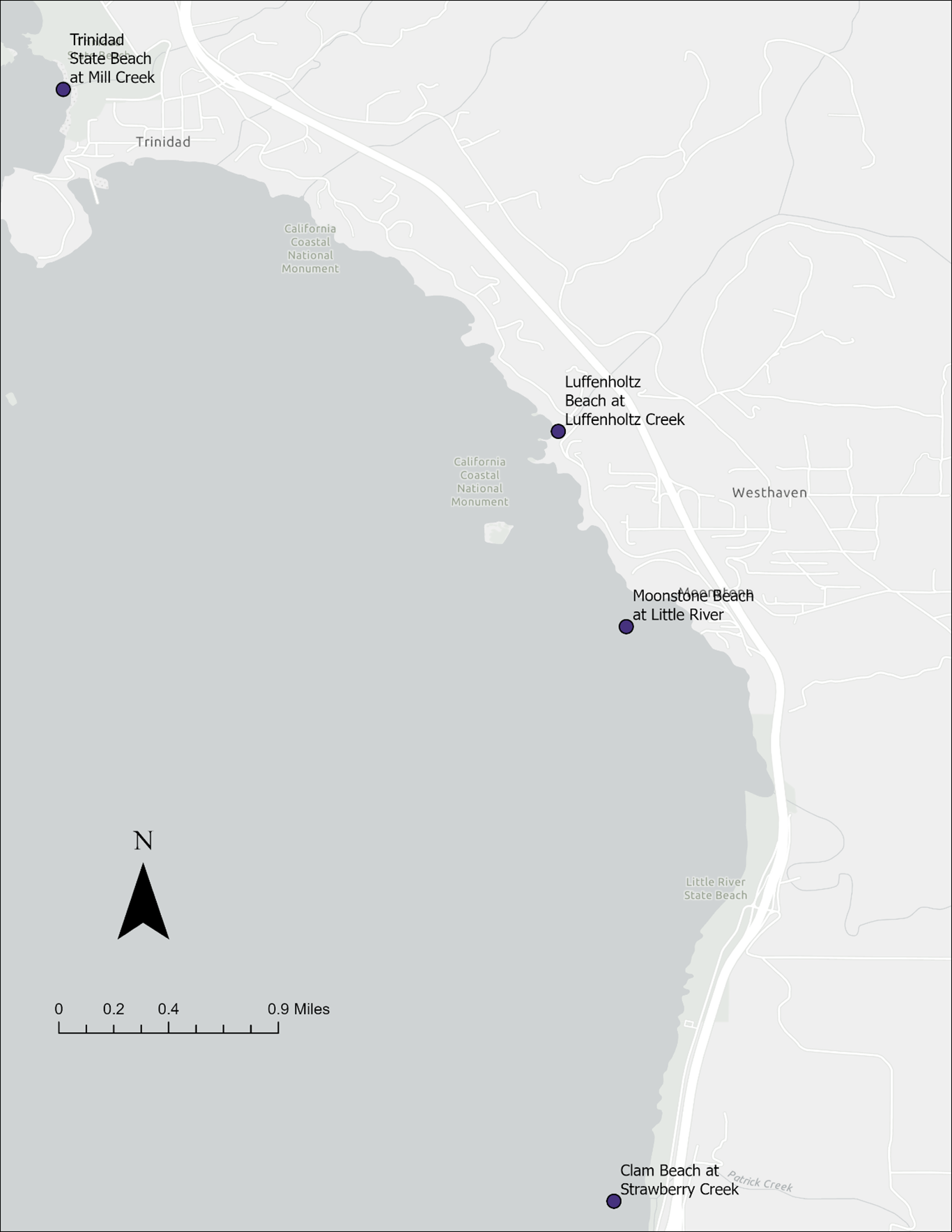
Impaired Ocean Beaches in Humboldt County addressed in the Implementation Plan
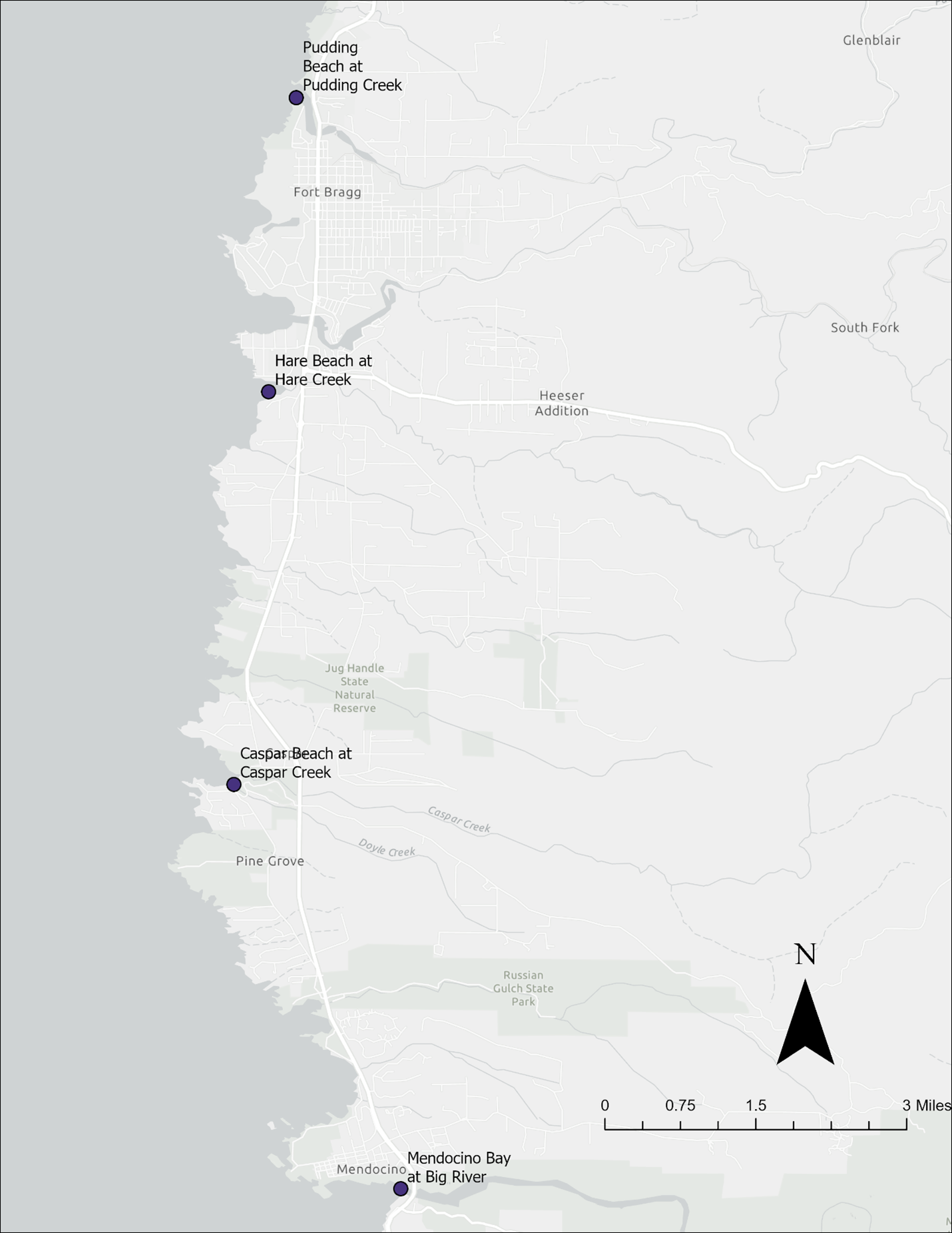
Impaired Ocean Beaches in Mendocino County addressed in the Implementation Plan
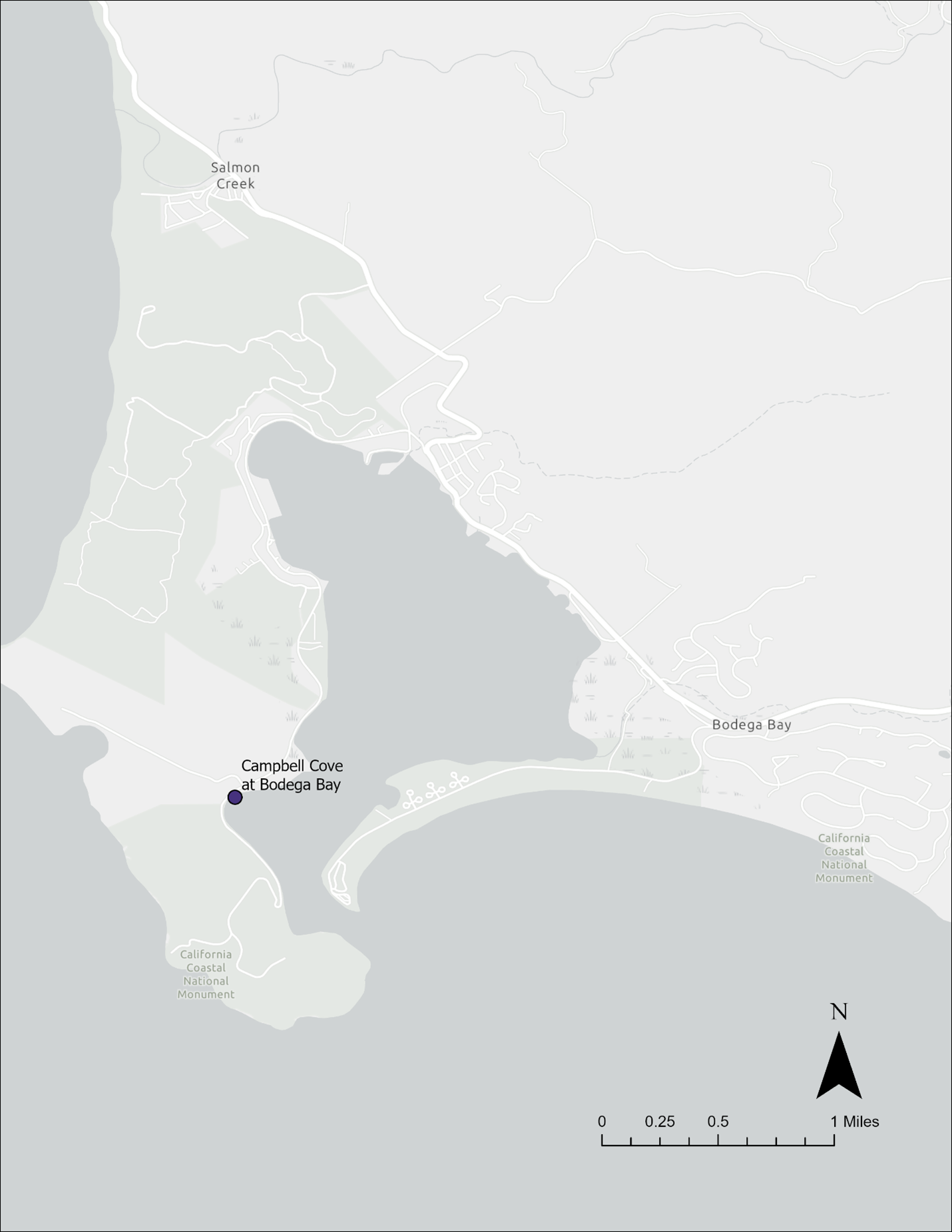
Impaired Ocean Beach in Sonoma County addressed in the Implementation Plan
Polluted Streams (Currently not listed as impaired on the Section 303(d) List) addressed in the Implementation Plan
The primary goal of the Implementation Plan is to restore supporting conditions for beneficial uses and ensure compliance with water quality objectives in the impaired waterbodies impacted by anthropogenic activities generating fecal waste. In order to prevent future impairments, the Implementation Plan also addresses polluted waterbodies that have not been identified as impaired, but do show exceedances of the REC1 objective.
Available data indicates that all six impaired coastal streams, 13 coastal streams with exceedances of the REC1 Objective, and nine REC1 and/or SHELL impaired ocean beaches all have anthropogenic sources of pollution that can be controlled – specifically, fecal waste from humans, dogs, and cattle. Three impaired ocean beaches are not addressed in the Implementation Plan as these beaches did not show evidence of anthropogenic fecal sources that could be controlled. Available data collected from these three beaches points to gulls, deer, and elk as the sources of fecal pollution.
The Implementation Plan does not establish or change any existing regulations but rather references existing regulatory and nonregulatory actions that are expected to result in attainment of objectives in these waterbodies. The Implementation Plan describes pollutant sources to the impaired and polluted waterbodies and describes ongoing and expected implementation actions to reduce pollutant loading.
The Plan identifies pet waste, onsite wastewater treatment systems (OWTS), stormwater runoff, damaged, defective, or nonfunctioning wastewater collection systems, grazing, recreation, and transient communities as potential causes of pollution to these waterbodies and outlines actions to reduce potential pollutant discharges due to all these causes and sources.
An overview of the regulatory mechanisms currently being used to control dog, human, and cattle fecal waste sources in the waterbodies on the Action and Watch Lists is provided below:
- Dog and Human Fecal Waste Sources
- Proposed requirements within the upcoming Phase II Municipal Separate Stormwater System (MS4) Permit
- Sanitary Sewer Systems (SSS) General Order
- Humboldt, Mendocino, and Sonoma County Local Area Management Plan (LAMP) requirements for OWTS and septic systems
- Existing Pet Waste Control Mechanisms employed by California Department of Parks and Recreation, Humboldt County Parks Department, Trinidad Coastal Land Trust, Mendocino Land Trust, and Jacoby Land Trust
- Existing and Upcoming pet waste, transient housing and community connection building, sewer system construction and improvement projects being conducted by the Cities of Arcata and Eureka
- Dairy and NonDairy Cattle Fecal Waste
- General Waste Discharge Requirements for Dairies in the North Coast Region (Dairy Permit)
- Existing enforcement action, and future action if needed, by the North Coast Water Board Enforcement program
Ongoing and foreseeable actions by the regulatory and non-regulatory bodies listed below using the mechanisms described above are expected to continue to improve and protect water quality in the waterbodies included in the Implementation Plan.
- Humboldt County Department of Environmental Health
- Humboldt County Public Works Department
- City of Arcata Environmental Services Department
- City of Eureka Public Works Department
- Jacoby Creek Land Trust
- Trinidad Coastal Land Trust
- Mendocino County Environmental Health Division
- Mendocino Land Trust
- North Coast Water Board Dairy Program
- North Coast Water Board Enforcement Program
- North Coast Water Board Storm Water Unit
- California Department of Parks and Recreation
Since 2020 and continuing through the early part of 2025, North Coast Water Board staff have actively engaged the interested parties that represent regulatory, environmental, and community perspectives to develop and conduct Coastal Pathogen Project sampling, share and obtain water quality data, and to develop and inform the Implementation Plan. The coordination has included meetings with both regulatory agencies and nongovernment organizations, including Humboldt County Department of Environmental Health, Humboldt County Public Works Department, City of Arcata Environmental Services Department, City of Eureka Public Works Department, Jacoby Creek Land Trust, Trinidad Coastal Land Trust, Humboldt Waterkeeper, Mendocino County Environmental Health Division, Mendocino Land Trust, North Coast Water Board Dairy Program, North Coast Water Board Enforcement Program, North Coast Water Board Storm Water Unit, California Department of Parks and Recreation, and the State Water Resources Control Board. Staff also distributed fact sheets to these entities as well as five Native American tribes (Trinidad Rancheria, Wiyot Tribe, Yurok Tribe, Round Valley Indian Tribes, Federated Indians of Graton Rancheria) with lands in the watersheds of the waterbodies included in the Implementation Plan, describing the Implementation Plan in order to provide information and solicit feedback.
Technical Reports
- Assessment of Fecal Indicator Bacteria Data from 21 Humboldt County Coastal Streams
- Assessment of Fecal Indicator Bacteria Data from 19 North Coast Ocean Beaches
- Assessment of Land Cover, Land Use, and Microbial Source Tracking Data from 28 Coastal Streams, and 12 Ocean Beaches in the North Coast Region
- Assessment of Fecal Indicator Bacteria and Microbial Source Tracking Data from Jolly Giant Creek
- Coastal Pathogen Project Synthesis Report
- An Interpretation of the North Coast Regional Water Quality Control Board Narrative Natural Background Water Quality Objective for Bacteria as Applied in Freshwater Streams of the Coast Range Ecoregion
Technical Memoranda
- 2022 Salinity Study
- Exclusion of Specific Source Assessment Study Sampling Stations from Fecal Indicator Bacteria and Microbial Source Tracking Data Assessment
- Technical Reports and Memoranda of the Coastal Pathogen Project
Fact Sheet
Quality Assurance Project Plans
- Coastal Watershed Pathogen Indicator Study Quality Assurance Project Plan
- Jolly Giant Creek Study Monitoring Plan
- Salinity Study Monitoring Plan
Contact Us
- Prachi Kulkarni, Water Resource Control Engineer
707-576-2650
Prachi.Kulkarni@Waterboards.ca.gov
- Lisa Bernard, Planning Unit Supervisor
707-576-2677
lisa.bernard@waterboards.ca.gov
Stay Informed
To receive notices and the timeliest information on the Coastal Pathogen Project via e-mail, please subscribe to our Basin Planning mailing list here: GovDelivery Sign-up
Resources
TMDL Projects
- Albion River
- Big River
- Coastal Pathogens
- Eel River, North Fork
- Eel River, Upper Main
- Eel River, Middle Main
- Eel River, Middle Fork
- Eel River, Lower Main
- Eel River, South Fork
- Elk River
- Freshwater Creek
- Garcia River
- Gualala River
- Klamath River
- Laguna De Santa Rosa
- Lost River, Upper
- Lost River, Lower
- Mad River
- Mattole River
- Navarro River
- Noyo River
- Redwood Creek
- Russian River
- Salmon River
- Scott River
- Shasta River
- Stemple Creek
- Ten Mile River
- Trinity River
- Trinity River, South Fork
- Van Duzen River
(Page last updated 7/8/26)
Water is a precious resource in California, and maintaining its quality is of utmost importance to safeguard the health of the public and the environment.
Statewide Campaigns
EPA Water Sense
File an Environmental Complaint
Save Our Water
Flex Alert
Register to Vote
