Santa Rosa Island Rehabilitiation
Rangeland and Road Management Practices
Project Purpose:
To abate rangeland and road management practices at Santa Rosa Island which degrade riparian habitat, degrade water quality, and induce sediment transport into surface waters.
Project Description:
Santa Rosa Island, one of four of the Channel Islands off the coast of Santa Barbara, is 15 miles long and 10 miles wide, with varying topography and approximately 46 miles of shoreline. It is a diverse island of grass-covered rolling hills, steep canyons, creeks, rocky intertidal areas and sandy beaches. Rocky terraces on the west end provide habitat for intertidal organisms. The coastal marsh is an extensive freshwater habitat. It has few structures and hosts mainly campers and hikers.
Animal grazing (cattle, sheep, deer, and elk) occurred historically on the Channel Islands and was allowed to continue when the National Parks Service assumed operation and management of the lands. The historic grazing degraded riparian areas, created conditions of land erosion, and improperly managed roads also contributed to the erosion.
After working voluntarily with the National Park Service and grazing operations failed to improve conditions, the Central Coast Water Board issued a Cleanup and Abatement Order(Order No. 95-064) to abate rangeland and road management practices which degrade riparian habitat, degrade water quality, and induce sediment transport into surface waters of Santa Rosa Island.
Project Results
The National Park Service is now implementing a riparian zone recovery plan and a road management plan. The riparian zone recovery plan resulted in the elimination of cattle from the island in 1998 (sheep were eliminated in the early 1900's) and also substantially reduced numbers of deer.
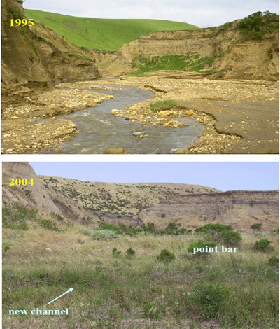
After cattle were removed, watercourses on Santa Rosa Island saw dramatic improvements in riparian vegetation cover and water quality. An example of recovery is shown below.
How Success Was Measured:
Water quality data was collected at multiple sites at three streams. A statistical comparison of monitoring data from 2002 (six years following removal of the cattle) and monitoring data from 1993 to 1998 was conducted to determine the significance of water quality changes that have occurred. The shading effect of increased riparian cover created a larger difference between stream water and air temperatures. A significant decline in total suspended sediments indicated a reduction in the rate of stream erosion. Nutrient levels were reduced by as much as 90% at all sites reflecting dramatic changes that cattle removal has had on stream nutrient loading. Significant reduction in total and fecal coliform levels were also observed.
In addition, water quality improvements are clearly shown in the before and after photos. Prior to removal and management of cattle, creeks had no plant protection, steep slopes eroded into the stream, and hillsides were covered with non-native grasses. As shown below in 2004, bushes and trees flourished on the hillside and in the streambed preventing erosion and decreasing sediment loading. The creek now meanders through the cool cover of the natural vegetation.
Contact:
Howard Kolb at:
Howard.Kolb@waterboards.ca.gov, 805-549-3332
