
2018 Integrated Report Map
About the Map
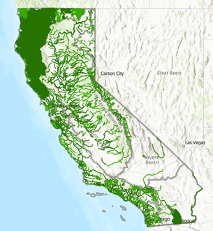
This map displays the assessed waterbodies included in the California 2018 Integrated Report. Assessed waterbodies are surface waterbodies, such as rivers, lakes, and beaches, that are placed in one of five Integrated Report Condition Categories based on a waterbody’s ability to support beneficial use(s). The 303(d) list portion of the California Integrated Report consists of waterbodies in Categories 4a, 4b, and 5. These waterbodies can be referred to as “listed” or “impaired”. The waterbody assessments are included in the map as a pop-up or in the attribute table. For more information about how Integrated Report assessments are structured, visit the About the Integrated Report page.
Access layers as a map service
Download geodatabase (44 Mb)
Note, the waterbodies and data in the map are for informational purposes only. Please direct questions on the map layers to the Surface Water Quality Assessment program at this address: WQAssessment@waterboards.ca.gov
