
2020-2022 California Integrated Report
For the 2020-2022 California Integrated Report, data from waterbodies in the Central Coast, Central Valley, and San Diego Regional Water Quality Control Boards regions were assessed as “on-cycle assessments.” In addition, data from waterbodies in the Colorado River Basin Regional Water Quality Control Board region conducted “off-cycle” assessments for one or more waterbodies within their region. The 2020-2022 California Integrated Report was approved by the EPA on May 11, 2022.
2020-2022 California Integrated Report Map
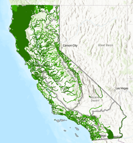
About the Map
This map displays the assessed waterbodies included in the California 2020-2022 Integrated Report. Assessed waterbodies are surface waterbodies, such as rivers, lakes, and beaches, that are placed in one of five Integrated Report Condition Categories based on a waterbody’s ability to support beneficial use(s). The California 303(d) list portion of the California Integrated Report consists of waterbodies in Categories 4a, 4b, and 5. These waterbodies can be referred to as “listed” or “impaired”. The waterbody assessments are included in the map as a pop-up or in the attribute table.
Note, the waterbodies and data in the map are for informational purposes only and can be updated periodically. Please direct questions on the map layers to the Surface Water Quality Assessment program at this address: WQAssessment@waterboards.ca.gov
Reports and Downloads
- 303(d) List: Download a list of impaired waterbody pollutant combinations
- Waterbody Fact Sheets: View and download waterbody fact sheets for each assessed waterbody
- Category Reports
Adoption Meeting, Final Staff Report, and Final Response to Comments – March 23, 2022
- Recording of January 19, 2022 Board Meeting – see Item 9 for Adoption of 2020-2022 Integrated Report for Clean Water Act 303(d) List and 305(b) Report
- Final Resolution for the 2020-2022 Integrated Report for Clean Water Act 303(d) List and 305(b) Report
- Final Summary of Comments and Responses for the 2020-2022 Integrated Report for Clean Water Act 303(d) List and 305(b) Report
- Final Staff Report for the 2020-2022 Integrated Report for Clean Water Act 303(d) List and 305(b) Report
- Final Revised Appendix A: Recommended 2020-2022 303(d) List of Impaired Waters
- Final Revised Appendix B: Statewide Waterbody Fact Sheets
- Final Revised Appendix C: Integrated Report Condition Category Reports
- Appendix C1: Category 1 Waterbody Segments
- Appendix C2: Category 2 Waterbody Segments
- Appendix C3: Category 3 Waterbody Segments
- Appendix C4a: Category 4a Waterbody Segments
- Appendix C4b: Category 4b Waterbody Segments
- Appendix C4c: Category 4c Waterbody Segments
- Appendix C5: Category 5 Waterbody Segments
- Final Appendix D: List of Adopted TMDLs
- Final Appendix E: Generalized Flowchart for Fish Tissue Mercury Objective Assessments
- Final Appendix F: Miscellaneous Mapping Changes Report
- Final Appendix G: Reference Reports
- Appendix G1: Region 1 Reference Report
- Appendix G2: Region 2 Reference Report
- Appendix G3: Region 3 Reference Report
- Appendix G4: Region 4 Reference Report
- Appendix G5: Region 5 Reference Report
- Appendix G6: Region 6 Reference Report
- Appendix G7: Region 7 Reference Report
- Appendix G8: Region 8 Reference Report
- Appendix G9: Region 9 Reference Report
- Appendix G10: Statewide Reference Report
- Final Appendix H: 2018 303(d) List of Impaired Waters
- Final Revised Appendix I: Central Coast Regional Water Board – New Waterbody-Pollutant Combination Listings and Delistings
- Final Revised Appendix J: Central Valley Regional Water Board – New Waterbody-Pollutant Combination Listings and Delistings
- Final Appendix K: San Diego Regional Water Board – New Waterbody-Pollutant Combination Listings and Delistings
- Final Appendix L: Colorado River Basin Regional Water Board – New Waterbody-Pollutant Combination Listings and Delistings
- Final Appendix M: List of Retired Lines of Evidence
- Final Appendix N: List of Summing Pollutants
- Final Appendix O: List of Central Valley Regional Water Board Mis-Mapped Stations to be Corrected
- Final Appendix P: List of Decisions to Correct Pyrethroids in Sediment Labelling Error
- Final Appendix Q: List of Decisions to Correct for Westside San Joaquin Coalition Pesticide Data Re-Assessments
- Final Appendix R: List of Central Valley Regional Water Board Station Location Revisions to Correct Mapping Error and Listing Recommendation Updates
- Final Appendix S: List of Central Valley Regional Water Board Revised Trihalomethane Decisions
- Final Appendix T: List of Central Valley Regional Water Board Corrected Dissolved Oxygen SSO LOEs
- Final Appendix U: List of Central Valley Regional Water Board Revised Decisions Associated with Stormwater Outfall Sites
- Final mapping visualization tool for the 2020-2022 Integrated Report for Clean Water Act 303(d) List
First Revised Proposed Final Staff Report - January 14, 2022
- First Revised Proposed Final Staff Report for the 2020-2022 Integrated Report for Clean Water Act 303(d) List and 305(b) Report
- Revised Appendix A: Recommended 2020-2022 303(d) List of Impaired Waters
- Revised Appendix B: Statewide Waterbody Fact Sheets
- Revised Appendix C: Integrated Report Condition Category Reports
- Appendix C1: Category 1 Waterbody Segments
- Appendix C2: Category 2 Waterbody Segments
- Appendix C3: Category 3 Waterbody Segments
- Appendix C4a: Category 4a Waterbody Segments
- Appendix C4b: Category 4b Waterbody Segments
- Appendix C4c: Category 4c Waterbody Segments
- Appendix C5: Category 5 Waterbody Segments
- Revised Appendix I: Central Coast Regional Water Board – New Waterbody-Pollutant Combination Listings and Delistings
- Revised Appendix J: Central Valley Regional Water Board – New Waterbody-Pollutant Combination Listings and Delistings
- 2020-2022 Aluminum Data Set for Cursory Review
Notices and Proposed Final Integrated Report, Staff Report, and Response to Comments - December 17, 2021
- Notice of Consideration of Adoption of California’s 2020-2022 Clean Water Act Section 303(d) List, and Notice of Availability of Proposed Final Documents and Responses to Comments
- Proposed Final Summary of Comments and Responses for the 2020-2022 Integrated Report for Clean Water Act 303(d) List and 305(b) Report
- Proposed Final Staff Report for the 2020-2022 Integrated Report for Clean Water Act 303(d) List and 305(b) Report
- Appendix A: Recommended 2020-2022 303(d) List of Impaired Waters
- Appendix B: Statewide Waterbody Fact Sheets
- Appendix C: Integrated Report Condition Category Reports
- Appendix C1: Category 1 Waterbody Segments
- Appendix C2: Category 2 Waterbody Segments
- Appendix C3: Category 3 Waterbody Segments
- Appendix C4a: Category 4a Waterbody Segments
- Appendix C4b: Category 4b Waterbody Segments
- Appendix C4c: Category 4c Waterbody Segments
- Appendix C5: Category 5 Waterbody Segments
- Appendix D: List of Adopted TMDLs
- Appendix E: Generalized Flowchart for Fish Tissue Mercury Objective Assessments
- Appendix F: Miscellaneous Mapping Changes Report
- Appendix G: Reference Reports
- Appendix G1: Region 1 Reference Report
- Appendix G2: Region 2 Reference Report
- Appendix G3: Region 3 Reference Report
- Appendix G4: Region 4 Reference Report
- Appendix G5: Region 5 Reference Report
- Appendix G6: Region 6 Reference Report
- Appendix G7: Region 7 Reference Report
- Appendix G8: Region 8 Reference Report
- Appendix G9: Region 9 Reference Report
- Appendix G10: Statewide Reference Report
- Appendix H: 2018 303(d) List of Impaired Waters
- Appendix I: Central Coast Regional Water Board – New Waterbody-Pollutant Combination Listings and Delistings
- Appendix J: Central Valley Regional Water Board – New Waterbody-Pollutant Combination Listings and Delistings
- Appendix K: San Diego Regional Water Board – New Waterbody-Pollutant Combination Listings and Delistings
- Appendix L: Colorado River Basin Regional Water Board – New Waterbody-Pollutant Combination Listings and Delistings
- Appendix M: List of Retired Lines of Evidence
- Appendix N: List of Summing Pollutants
- Appendix O: List of Central Valley Regional Water Board Mis-Mapped Stations to be Corrected
- Appendix P: List of Decisions to Correct Pyrethroids in Sediment Labelling Error
- Appendix Q: List of Decisions to Correct for Westside San Joaquin Coalition Pesticide Data Re-Assessments
- Appendix R: List of Central Valley Regional Water Board Station Location Revisions to Correct Mapping Error and Listing Recommendation Updates
- Appendix S: List of Central Valley Regional Water Board Revised Trihalomethane Decisions
- Appendix T: List of Central Valley Regional Water Board Corrected Dissolved Oxygen SSO LOEs
- Appendix U: List of Central Valley Regional Water Board Revised Decisions Associated with Stormwater Outfall Sites
- Final mapping visualization tool for the 2020-2022 Integrated Report for Clean Water Act 303(d) List
Notices and Draft Staff Report
- Video recording of the July 6, 2021 State Water Board Hearing on the draft 303(d) list
- Presentation slides for the July 6, 2021 State Water Board Hearing on the draft 303(d) list
- Notice of Public Hearing and Opportunity for Public Comment for the Draft 2020-2022 California Clean Water Act Section 303(d) List
- Draft Staff Report for the 2020-2022 Integrated Report for Clean Water Act 303(d) List and 305(b) Report
- Appendix A: Recommended 2020-2022 303(d) List of Impaired Waters
- Appendix B: Statewide Waterbody Fact Sheets
- Appendix C: Integrated Report Condition Category Reports
- Appendix C1: Category 1 Waterbody Segments
- Appendix C2: Category 2 Waterbody Segments
- Appendix C3: Category 3 Waterbody Segments
- Appendix C4a: Category 4a Waterbody Segments
- Appendix C4b: Category 4b Waterbody Segments
- Appendix C4c: Category 4c Waterbody Segments
- Appendix C5: Category 5 Waterbody Segments
- Appendix D: List of Adopted TMDLs
- Appendix E: Generalized Flowchart for Fish Tissue Mercury Objective Assessments
- Appendix F: Miscellaneous Mapping Changes Report
- Appendix G: Reference Reports
- Appendix G1: Region 1 Reference Report
- Appendix G2: Region 2 Reference Report
- Appendix G3: Region 3 Reference Report
- Appendix G4: Region 4 Reference Report
- Appendix G5: Region 5 Reference Report
- Appendix G6: Region 6 Reference Report
- Appendix G7: Region 7 Reference Report
- Appendix G8: Region 8 Reference Report
- Appendix G9: Region 9 Reference Report
- Appendix G10: Statewide Reference Report
- Appendix H: 2018 303(d) List of Impaired Waters
- Appendix I: Central Coast Regional Water Board – New Waterbody-Pollutant Combination Listings and Delistings
- Appendix J: Central Valley Regional Water Board – New Waterbody-Pollutant Combination Listings and Delistings
- Appendix K: San Diego Regional Water Board – New Waterbody-Pollutant Combination Listings and Delistings
- Appendix L: Colorado River Basin Regional Water Board – New Waterbody-Pollutant Combination Listings and Delistings
- Appendix M: List of Retired Lines of Evidence
- Draft mapping visualization tool for the 2020-2022 Integrated Report for Clean Water Act 303(d) List.
- 2020-2022 Revised Data Solicitation Notice
- 2020-2022 Data Solicitation Notice
- 2020-2022 Data Dictionary
