Cape Mendocino
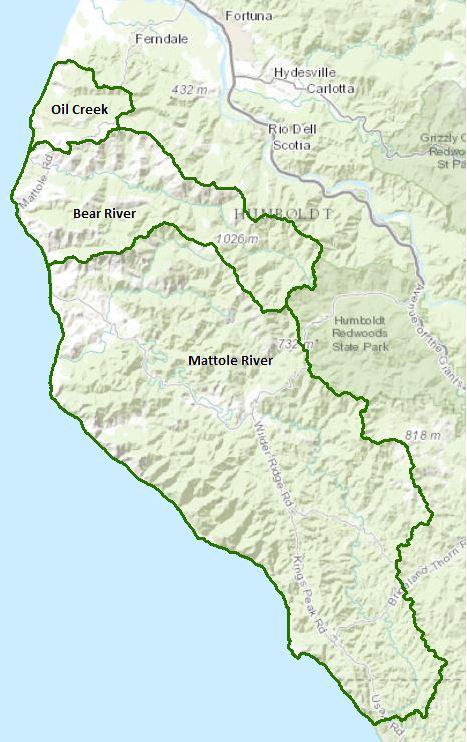
This hydrologic unit encompasses three hydrologic areas (HA), listed below. Only the Mattole River watershed has a separate page. All of these HAs include the near shore coastal areas.
Oil Creek Watershed
(HA 112.10)
Capetown HA – Bear River Watershed
(HA 112.20)
Mattole River Watershed
(HA 112.30)
Watershed information links for the Cape Mendocino Hydrologic Unit in general are listed below. The individual watershed page for the Mattole contains additional links specific to that watershed.
Water Quality, Flow, and Water Rights
2012 Water Quality Assessment Report
Every six years the North Coast Water Board evaluates water quality information and identifies water bodies that do not meet water quality standards and are not supporting their beneficial uses. Those waters are placed on a list of impaired water bodies that identifies the pollutant or stressor causing impairment and establishes a schedule for developing a control plan to address the impairment.
Impaired Water Bodies in the Mattole River Hydrologic Area |
||
Water Body Name |
Listing Extent |
Pollutant |
Mattole River HA, |
Entire water body |
Sedimentation / Siltation Temperature |
Main program page:
Map of water quality listed segments. (Click on the map tab)
Facilities Regulated by the Regional Water Board
This link is an interactive map of permitted facilities in California. You can zoom in to the watershed of your choice and click on a facility to obtain information.
Sanitary Sewer Overflow Incident Map
This link is an interactive map of overflows from sanitary sewers. You can zoom in to the watershed of your choice and click on an incident to obtain information.
2008 North Coast Water Board's Sediment TMDL Implementation Workplan
The Regional Water Board adopted a TMDL implementation policy statement in 2004 and a subsequent Workplan in 2008 that details efforts to address sediment impaired water bodies in the region. The section on the Mattole River watershed begins on page 149.
Water Rights Database
Statements of water diversion and use, registrations, certificates and water rights permits are accessible on the eWRIMS, electronic Water Rights Information Management System. This link includes a mapping application.
California Environmental Data Exchange Network
Water quality and habitat data and information are contained at this site in a spreadsheet format. Pay careful attention to the instructions.
Landscape Information
2005 N. Coast Water Board Watershed Initiative Chapter, North Coast Rivers
The North Coast Region developed a Watershed Initiative Chapter as part of the State Water Board's Watershed Management Initiative that provides an overview of that watershed, a description of its water quality concerns and issues, past significant Regional Board activities in the watershed, activities as of 2005, near-term activities that would benefit the watershed, and activities which may happen on a longer time-scale.
North Coast rivers
King Range National Conservation Area
The King Range NCA was designated as the nation's first NCA in 1970. It is 68,000 acres in extent and includes 35 miles of remote and dramatic coast line, also known as the Lost Coast. The NCA is administered by the federal Bureau of Land Management.
California Geographic Information Portal
This portal has a search engine for the portal itself and ArcGIS online. Information and GIS layers can be accessed for a variety of data, including hillshade, vegetation, rivers, contours, stream fish habitat by reach, stream inventory reports, and CalWater 2.2 maps.
CalFire Fire and Resource Assessment Program
This site contains a wealth of information on the amount and extent of forest and rangelands along with analysis of conditions. Maps, projects, and assessments are available on the site, including GIS layers for timber harvesting, vegetation, and other resources.
U.S. Natural Resources Conservation Service Geospatial Data Gateway
Environmental and natural resources GIS files are available at this site, along with an interactive national map viewer.
Watershed Condition Information
Critical Coastal Areas
This program is administered by the California Coastal Commission and State Water Resources Control Board to foster collaboration on addressing issues associated with polluted runoff in critical coastal areas. Both the Mattole River and King Range are listed in this program.
Marine Protected Areas
The Cape Mendocino Hydrologic Unit drains into four protected and/or special regulation areas, administered by the California Department of Fish and Wildlife.
California EcoAtlas
This website provides access to information on wetlands, including integration of some water quality information.
Watershed Groups, Partnerships, and Collaboration
Salmonid Restoration Federation
This nonprofit group was formed in 1986 to assist salmonid restoration efforts in California by promoting "restoration, stewardship, and recovery of California native salmon, steelhead and trout populations through education, collaboration, and advocacy." Their web site contains a wealth of information on salmonids and habitat and stream restoration in California.
California Watershed Network
This nonprofit organization was formed in 2000 to help protect and restore watersheds in California through community-based networks. The website contains some information on watershed events and older information on watersheds of interest, but most of it has not been updated since 2011.
UC Davis Information Center for the Environment, Natural Resource Project Inventory
This database provides information on natural resource projects in California, including links to data and information collected by the projects.
Fisheries and Wildlife Information
CA Department of Fish and Wildlife Stream Inventory Reports
This California DFW site allows searches by major watershed areas (search on North Coast and Mattole).
National Oceanic and Atmospheric Administration
NOAA Fisheries is responsible for listing and recovery efforts for anadromous fishes. The recovery plans for coho salmon and steelhead contain information on the habitat, population status, stressors and threats, recovery efforts, and recovery strategy (includes the Mattole and Bear rivers).
Coho salmon
Steelhead trout
King Range Area of Special Biological Significance
The State Water Resources Control Board has designated Areas of Special Biological Significance (ASBS) as those "ocean areas requiring protection of species of biological communities to the extent that alteration of natural water quality is undesirable." They are included under the Marine Managed Areas Improvement Act (The Marine Managed Areas Improvement Act (Chapter 7 (commencing with Section 36600) of Division 27 of the Public Resources Code.)
Main report with legal descriptions and maps
1979 Reconnaissance Survey Report
CalFish Cooperative Anadromous Fish and Habitat Data Program
This cooperative agency site provides information on anadromous fish habitat and populations in an interactive environment. The site has numerous links to information libraries and systems in California.
The Nature Conservancy's "California Salmon Snapshots"
This website contains information on salmon populations and resources in California. This link provides information on the Mattole River watershed.
The links and information on this page are provided in an attempt to make a broad range of information available on a watershed basis. While the Water Board has been involved in work within watersheds with a variety of agencies and watershed groups, we cannot vouch for the currency or accuracy of information contained within the internet links we have included. We suggest that you check with the original sources if there is any question regarding currency, accuracy, or origin of information.
Created February 16, 2016
Web page contact : Robert Klamt, rklamt@waterboards.ca.gov
(Page last updated 5/25/18)
Water is a precious resource in California, and maintaining its quality is of utmost importance to safeguard the health of the public and the environment.
Statewide Campaigns
EPA Water Sense
File an Environmental Complaint
Save Our Water
Flex Alert
Register to Vote
