Freshwater Creek – HUCs 110.000101, 102, 103, 104, 105
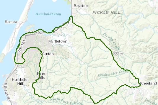
The Freshwater Creek watershed is the second largest freshwater tributary to Humboldt Bay encompassing just under 20,000 acres. The watershed trends from the moderately steep upper areas at a maximum elevation of 2850 feet northwest towards lower gradient hill slopes and dropping to alluvial flats as it enters Eureka Slough, thence Humboldt Bay. The predominant geology is sedimentary and most of the watershed is redwood-fir forest with grass tidal flats in the lower western portions. Wet mild winters and foggy cool summers are typical with annual rainfall amounts ranging from 40-75 inches, most occurring as rain October through April.
Timberland management is the predominant land use, with about 78% in private ownership. Land use in the lower slopes and flats includes urban development, rural subdivision, recreation, and small private industry.
The watershed has a long history of timberland management, historical records documenting logging in the 1860s. Logging before the late 1950s was predominantly clearcutting with cable yarding, peaking in the 1930s. Nearly the entire watershed was clearcut logged by the 1950s. Harvesting rates declined in the 1940s and 1950s and then picked up again in the late 1960s as lower basin second-growth forests were commercially thinned. Timber harvesting in the watershed increased in the 1990s, peaking in the years between 1998 and 2003.
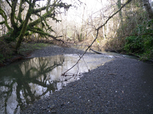
Sedimentation and siltation of the Freshwater Creek watershed's stream courses resulted as a consequence of the high amount of ground disturbance, the geology and soils, the high rainfall amounts, and moderately steep terrain. The effects of excessive sedimentation were documented in 1997 as impairments to multiple beneficial uses, including the cold water fishery, domestic water supplies, and agricultural water supplies. Excessive sedimentation also has caused an increased incidence of flooding resulting in permanent or temporary loss or reduced use of both private and public property, as well as risks to the health and welfare of the local community.
Timber harvesting activities in the watershed currently are intensely regulated and monitored. The two major industrial timber land owners, Humboldt Redwoods Company and Green Diamond Resource Company, currently operate under federal Habitat Conservation Plans, Incidental Take Permits, Forest Stewardship Certification, and Water Board permits.
Water Quality, Flow, and Water Rights
2012 Water Quality Assessment Report & 303(d) List of Impaired Waters
The Water Board evaluates water quality information and identifies water bodies that do not meet water quality standards and are not supporting their beneficial uses. Those waters are placed on a list of impaired water bodies that identifies the pollutant or stressor causing impairment and establishes a schedule for developing a control plan to address the impairment. The entire Freshwater Creek watershed is listed for impairments from sedimentation and siltation.
Main program page:
Map of water quality listed segments. (Click on the map tab)
Elk River and Freshwater Creek Sediment Monitoring Project
This link provides information on a cooperative sediment monitoring program in these two watersheds from 2008 to 2013.
2013 Salmon Forever Annual Report on Suspended Sediment, Peak Flows, and Trends
This project provides information on both Elk River and Freshwater Creek in partial fulfillment of a grant agreement between the State Water Resources Control Board and the Redwood Community Action Agency.
Scour, Fill, and Salmon Spawning in a Northern California Coastal Stream, 2003 Masters Thesis, P.E. Bigelow
2008 North Coast Water Board's Sediment TMDL Implementation Workplan
The Regional Water Board adopted a TMDL implementation policy statement in 2004 and a subsequent Workplan in 2008 that details efforts to address sediment impaired water bodies in the region
2001 Peak Flow Estimates by CalFire
The California Department of Forestry and Fire Protection estimated the effects of timber harvesting on peak flows in the Freshwater Creek watershed.
Water Rights Database
Statements of water diversion and use, registrations, certificates and water rights permits are accessible on the eWRIMS, electronic Water Rights Information Management System. This link includes a mapping application.
California Environmental Data Exchange Network
This site, maintained by the State Water Resources Control Board, contains water quality and habitat information in a spreadsheet format. It can be a bit confusing to use, so pay careful attention to the instructions.
Landscape Information
California Geographic Information Portal
This portal has a search engine for the portal itself and ArcGIS online. Information and GIS layers can be accessed for a variety of data, including hillshade, vegetation, rivers, contours, stream fish habitat by reach, stream inventory reports, and CalWater 2.2 maps.
2005 N. Coast Water Board Watershed Initiative Chapter, Humboldt Bay WMA
As part of the State Water Board's Watershed Management Initiative, the North Coast Region developed a Watershed Initiative Chapter that provides an overview of that watershed, a description of its water quality concerns and issues, past significant Regional Board activities in the watershed, activities as of 2005, near-term activities that would benefit the watershed, and activities which may happen on a longer time-scale.
CalFire Fire and Resource Assessment Program
This site contains a wealth of information on the amount and extent of forest and rangelands along with analysis of conditions. Maps, projects, and assessments are available on the site, including GIS layers for timber harvesting, vegetation, and other resources.
U.S. Natural Resources Conservation Service Geospatial Data Gateway
Environmental and natural resources GIS files are available at this site.
Watershed Condition Information
Independent Science Review Panel Reports
The North Coast Water Board convened an Independent Science Review Panel (ISRP) to review scientific information on the condition, biological resources, and water quality of five watersheds in Humboldt County, one of which was Freshwater Creek, with an eye to past, present, and proposed land use management, primarily timber harvest. Two reports were produced, termed "Phase I" (December 27, 2002) and "Phase II" (August 12, 2003).
Phase I ISRP Report
Phase II ISRP Report
Freshwater Creek TMDL for Sediment
The Freshwater Creek watershed is listed for impairments due to excessive sediment. Plans and documents include sediment source studies and slope stability modeling and landslide hazard mapping under the following link:
KRIS Humboldt Bay
This system was originally developed as a data repository and analysis and management tool for the Klamath River watershed. A host of information is available through this site, including maps, water quality data, fisheries data, photographs, and scientific references.
2003 Pacific Lumber Company Freshwater Creek Watershed Analysis Cumulative Effects Assessment
This assessment was required by the Habitat Conservation Plan and provides a considerable body of information on the watershed at that time.
California EcoAtlas
This website provides access to information on wetlands, including integration of some water quality information.
Watershed Groups, Partnerships, and Collaboration
California Watershed Network
This nonprofit organization was formed in 2000 to help protect and restore watersheds in California through community-based networks.
Fisheries and Wildlife Information
The Nature Conservancy's "California Salmon Snapshots"
This website contains information on salmon populations and resources in Freshwater Creek.
National Oceanic and Atmospheric Administration
NOAA Fisheries is responsible for listing and recovery efforts for anadromous fishes. The 2014 Recovery Plan for coho salmon in the Southern Oregon-North Coast of California ESU contains information on the habitat, population status, stressors and threats, recovery efforts, and recovery strategy.
Salmonid Restoration Federation
This nonprofit group was formed in 1986 to assist salmonid restoration efforts in California by promoting "restoration, stewardship, and recovery of California native salmon, steelhead and trout populations through education, collaboration, and advocacy." Their web site contains a wealth of information on salmonids and habitat and stream restoration in California.
UC Davis Information Center for the Environment, Natural Resource Project Inventory
This database provides information on natural resource projects in California, including links to data and information collected by the projects.
The links and information on this page are provided in an attempt to make a broad range of information available on a watershed basis. While the Water Board has been involved in work within watersheds with a variety of agencies and watershed groups, we cannot vouch for the currency or accuracy of information contained within the internet links we have included. We suggest that you check with the original sources if there is any question regarding currency, accuracy, or origin of information.
Created February 24, 2016 Web page contact: Robert Klamt, robert.klamt@waterboards.ca.gov
(Page last updated 5/25/18)
Water is a precious resource in California, and maintaining its quality is of utmost importance to safeguard the health of the public and the environment.
Statewide Campaigns
EPA Water Sense
File an Environmental Complaint
Save Our Water
Flex Alert
Register to Vote
