Trinidad - Hydrologic Unit 108
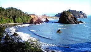
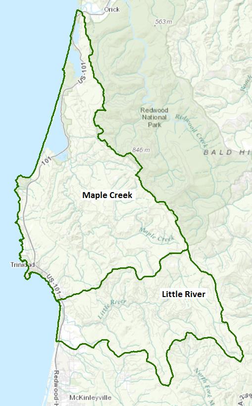
The Trinidad Hydrologic Unit includes a number of small coastal watersheds from just south of Redwood Creek to the Mad River, with the two largest being Maple Creek (and its estuary, Big Lagoon) and the Little River. The unit is characterized by steep coastal bluffs and redwood forested hills and three coastal lagoons noted for their unusual habitats and resources.
All three lagoons have extensive wetland habitats and Big and Stone lagoons often have salt water exchange. Freshwater Lagoon is effectively cut off from the ocean by Highway 101. Stone and Big lagoons and their tributaries, and the Little River support anadromous salmonid populations.
Water Quality, Flow, and Water Rights
2012 Water Quality Assessment Report
Every six years the North Coast Water Board evaluates water quality information and identifies water bodies that do not meet water quality standards and are not supporting their beneficial uses. Those waters are placed on a list of impaired water bodies that identifies the pollutant or stressor causing impairment and establishes a schedule for developing a control plan to address the impairment.
Impaired Water Bodies in the Trinidad Unit |
||
Water Body Name |
Listing Extent |
Pollutant |
Clam Beach (near Strawberry Creek)3 |
Entire water body |
Indicator Bacteria |
Dead Lake |
Entire water body |
Mercury |
Little River HA |
Little River |
Indicator Bacteria |
Luffenholtz Beach |
Entire water body |
Indicator Bacteria |
Moonstone County Park |
Entire water body |
Indicator Bacteria |
Old Home Beach |
Entire water body |
Indicator Bacteria |
Trinidad State Beach |
Entire water body |
Indicator Bacteria |
Main program page:
Map of water quality listed segments. (Click on the map tab)
Facilities Regulated by the Regional Water Board
This link is an interactive map of permitted facilities in California. You can zoom in to the watershed of your choice and click on a facility to obtain information.
Sanitary Sewer Overflow Incident Map
This link is an interactive map of overflows from sanitary sewers. You can zoom in to the watershed of your choice and click on an incident to obtain information.
Water Rights Database
Statements of water diversion and use, registrations, certificates and water rights permits are accessible on the eWRIMS, electronic Water Rights Information Management System. This link includes a mapping application.
California Environmental Data Exchange Network
This site, maintained by the State Water Resources Control Board, contains water quality and habitat information in a spreadsheet format. Pay careful attention to the instructions.
Landscape Information
2005 N. Coast Water Board Watershed Initiative Chapter, Humboldt Bay WMA
The North Coast Region developed a Watershed Initiative Chapter as part of the State Water Board's Watershed Management Initiative that provides an overview of that watershed, a description of its water quality concerns and issues, past significant Regional Board activities in the watershed, activities as of 2005, near-term activities that would benefit the watershed, and activities which may happen on a longer time-scale. The Trinidad Unit is included within the Humboldt Bay Watershed Management Area
California Geographic Information Portal
This portal has a search engine for the portal itself and ArcGIS online. Information and GIS layers can be accessed for a variety of data, including hillshade, vegetation, rivers, contours, stream fish habitat by reach, stream inventory reports, and CalWater 2.2 maps.
U.S. Natural Resources Conservation Service Geospatial Data Gateway
Environmental and natural resources GIS files are available at this site.
CalFire Fire and Resource Assessment Program
This site contains a wealth of information on the amount and extent of forest and rangelands along with analysis of conditions. Maps, projects, and assessments are available on the site, including GIS layers for timber harvesting, vegetation, and other resources.
Watershed Condition Information
California EcoAtlas
This website provides access to information on wetlands, including integration of some water quality information.
California Coastal Commission
The California Coastal Commission produced a report on the state of Critical Coastal Areas in 2006. The report provides a summary table of conditions and efforts to implement measures to control nonpoint source pollution as well as listing of regulatory and planning jurisdictions and contact information.
California EcoAtlas
This website provides access to information on wetlands, including integration of some water quality information.
Watershed Groups, Partnerships, and Collaboration
Redwood Community Action Agency's Natural Resource Service
This nonprofit group is involved in watershed assessments and restoration activities in the redwood region.
Salmonid Restoration Federation
This nonprofit group was formed in 1986 to assist salmonid restoration efforts in California by promoting "restoration, stewardship, and recovery of California native salmon, steelhead and trout populations through education, collaboration, and advocacy." Their web site contains a wealth of information on salmonids and habitat and stream restoration in California.
UC Davis Information Center for the Environment, Natural Resource Project Inventory
This database provides information on natural resource projects in California, including links to data and information collected by the projects.
California Watershed Network
This nonprofit organization was formed in 2000 to help protect and restore watersheds in California through community-based networks. The website contains some information on watershed events and older information on watersheds of interest, but most of it has not been updated since 2011.
Fisheries and Wildlife Information
Kelp Beds at Trinidad Head ASBS
The State Water Resources Control Board has designated Areas of Special Biological Significance (ASBS) as those "ocean areas requiring protection of species of biological communities to the extent that alteration of natural water quality is undesirable." They are included under the Marine Managed Areas Improvement Act (The Marine Managed Areas Improvement Act (Chapter 7 (commencing with Section 36600) of Division 27 of the Public Resources Code.) Main report with legal descriptions and maps:
Main report with legal descriptions and maps
1979 Reconnaissance Survey Report
National Oceanic and Atmospheric Administration
NOAA Fisheries is responsible for listing and recovery efforts for anadromous fishes. The 2014 Recovery Plan for coho salmon in the Southern Oregon-North Coast of California ESU contains information on the habitat, population status, stressors and threats, recovery efforts, and recovery strategies.
CalFish Cooperative Anadromous Fish and Habitat Data Program
This cooperative agency site provides information on anadromous fish habitat and populations in an interactive environment. The site has numerous links to information libraries and systems in California.
Maple Creek and Big Lagoon
Little River
Green Diamond Resource Company
Green Diamond manages timberlands in the Trinidad Unit watershed. Their research arm provides information on the wildlife, fishery, and botanical resources within their lands.
The links and information on this page are provided in an attempt to make a broad range of information available on a watershed basis. While the Water Board has been involved in work within watersheds with a variety of agencies and watershed groups, we cannot vouch for the currency or accuracy of information contained within the internet links we have included. We suggest that you check with the original sources if there is any question regarding currency, accuracy, or origin of information.
Created April 15, 2015; revised February 3, 2016
Web page contact: Robert Klamt, robert.klamt@waterboards.ca.gov(Page last updated 10/16/17)
Water is a precious resource in California, and maintaining its quality is of utmost importance to safeguard the health of the public and the environment.
Statewide Campaigns
EPA Water Sense
File an Environmental Complaint
Save Our Water
Flex Alert
Register to Vote
