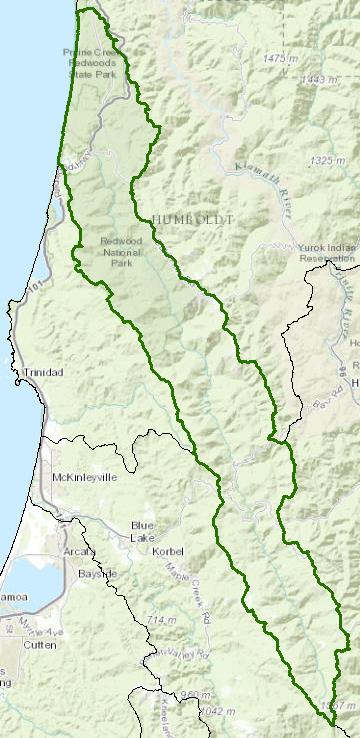
Redwood Creek Watershed - Hydrologic Unit 107
Redwood Creek flows from an elevation of 5,200 feet in a northwesterly direction to the Pacific Ocean about 35 miles north of the city of Eureka at Orick, California. The watershed is mostly forested, steep mountainous terrain, approximately 280 square miles in size. The watershed is quite narrow, averaging about 6 miles in width. The mainstem drops out of the headwaters to become a low gradient stream with short tributaries coming off of the steep hillsides. Redwood Creek is an important salmonid stream in the area. The lower portion and the estuary are within the Redwood National and State Parks; the upper watershed mostly private timber lands.
Water Quality, Flow, and Water Rights
Water Quality Assessment Report
Every six years the North Coast Water Board evaluates water quality information and identifies water bodies that do not meet water quality standards and are not supporting their beneficial uses. Those waters are placed on a list of impaired water bodies that identifies the pollutant or stressor causing impairment and establishes a schedule for developing a control plan to address the impairment.
Impaired Water Bodies in the Redwood Creek Unit | ||
|---|---|---|
Water Body Name |
Listing Extent |
Pollutant |
Redwood Creek |
Entire water body Entire water body except Larry Dam Creek |
Sedimentation/Siltation Temperature |
Main program page:
Map of water quality listed segments. (Click on the map tab)
1998 Redwood Creek TMDL for Sediment and Temperature
Facilities Regulated by the Regional Water Board
This link is an interactive map of permitted facilities in California. You can zoom in to the watershed of your choice and click on a facility to obtain information.
Sanitary Sewer Overflow Incident Map
This link is an interactive map of overflows from sanitary sewers. You can zoom in to the watershed of your choice and click on an incident to obtain information.
2015 Sediment TMDL Report Card
2008 North Coast Water Board Sediment TMDL Implementation Policy
The Regional Water Board adopted a TMDL implementation policy statement in 2004 and a subsequent Workplan in 2008 that details efforts to address sediment impaired water bodies in the region. Redwood Creek begins on page 170.
California Environmental Data Exchange Network
This site, maintained by the State Water Resources Control Board, contains water quality and habitat information in a spreadsheet format. It can be a bit confusing to use, so pay careful attention to the instructions.
Water Rights Database
Statements of water diversion and use, registrations, certificates and water rights permits are accessible on the eWRIMS, electronic Water Rights Information Management System. This link includes a mapping application.
US Geological Survey Water Resources Data
Stream flow and various water quality data are available at:
Landscape Information
2005 N. Coast Water Board Watershed Initiative Chapter, Humboldt Watershed Management Area
As part of the State Water Board's Watershed Management Initiative, the North Coast Region developed a Watershed Initiative Chapter that provides an overview of that watershed, a description of its water quality concerns and issues, past significant Regional Board activities in the area, activities as of 2005, near-term activities that would benefit the watershed, and activities which may happen on a longer time-scale.
California Geographic Information Portal
This portal has a search engine for the portal itself and ArcGIS online. Information and GIS layers can be accessed for a variety of data, including hillshade, vegetation, rivers, contours, stream fish habitat by reach, stream inventory reports, and CalWater 2.2 maps.
CalFire Fire and Resource Assessment Program
This site contains a wealth of information on the amount and extent of forest and rangelands along with analysis of conditions. Maps, projects, and assessments are available on the site, including GIS layers for timber harvesting, vegetation, and other resources.
U.S. Natural Resources Conservation Service Geospatial Data Gateway
Environmental and natural resources GIS files are available at this site, along with an interactive national map viewer.
Watershed Condition Information
Redwood National and State Parks
This website contains a wealth of information on the natural resources, cultural resources and history, and recreational and educational opportunities within the park.
Watershed analysis and assessment reports are available at:
Additional scientific publications are available for download from the Natural Resource Publications Management site for all National Parks
KRIS Redwood Creek
This system was originally developed as a data repository and analysis and management tool for the Klamath River watershed. A host of information is available through this site, including maps, water quality data, fisheries data, photographs, and scientific references.
California Coastal Commission
The California Coastal Commission produced a report on the state of Critical Coastal Areas in 2006, including Redwood Creek and the adjacent coastal area. The report provides a summary table of conditions and efforts to implement measures to control nonpoint source pollution as well as listing of regulatory and planning jurisdictions and contact information.
California EcoAtlas
This website provides access to information on wetlands, including integration of some water quality information.
Watershed Groups, Partnerships, and Collaboration
Redwood Creek Watershed Group
This watershed group developed an Integrated Watershed Strategy in 2006 to provide a means to address natural resource needs and protections through collaborative partnerships.
Salmonid Restoration Federation
This nonprofit group was formed in 1986 to assist salmonid restoration efforts in California by promoting "restoration, stewardship, and recovery of California native salmon, steelhead and trout populations through education, collaboration, and advocacy." Their web site contains a wealth of information on salmonids and habitat and stream restoration in California.
California Watershed Network
This nonprofit organization was formed in 2000 to help protect and restore watersheds in California through community-based networks. The website contains some information on watershed events and older information on watersheds of interest, but most of it has not been updated since 2011.
UC Davis Information Center for the Environment, Natural Resource Project Inventory
This database provides information on natural resource projects in California, including links to data and information collected by the projects.
Fisheries and Wildlife Information
Redwood National and State Parks ASBS
The State Water Resources Control Board has designated Areas of Special Biological Significance (ASBS) as those "ocean areas requiring protection of species of biological communities to the extent that alteration of natural water quality is undesirable." They are included under the Marine Managed Areas Improvement Act (The Marine Managed Areas Improvement Act (Chapter 7 (commencing with Section 36600) of Division 27 of the Public Resources Code.) The following 2003 report provides information on the Redwood Parks ASBS:
CA Dept Fish and Wildlife Stream Inventory Reports
This California DFW site allows searches by major watershed areas, including Redwood Creek tributaries.
National Oceanic and Atmospheric Administration
NOAA Fisheries is responsible for listing and recovery efforts for anadromous fishes. The 2014 Recovery Plan for coho salmon for Redwood Creek contains information on the habitat, population status, stressors and threats, recovery efforts, and recovery strategy.
The Nature Conservancy's "California Salmon Snapshots"
This website contains information on salmon populations and resources in California's streams.
California Trout
CalTrout has a number of projects throughout the state, including restoration efforts in the Redwood Creek estuary.
The links and information on this page are provided in an attempt to make a broad range of information available on a watershed basis. While the Water Board has been involved in work within watersheds with a variety of agencies and watershed groups, we cannot vouch for the currency or accuracy of information contained within the internet links we have included. We suggest that you check with the original sources if there is any question regarding currency, accuracy, or origin of information.
Created January 28, 2016
Web page contact : Robert Klamt, rober.klamt@waterboards.ca.gov
(Page last updated 11/17/20)
Water is a precious resource in California, and maintaining its quality is of utmost importance to safeguard the health of the public and the environment.
Statewide Campaigns
EPA Water Sense
File an Environmental Complaint
Save Our Water
Flex Alert
Register to Vote
