
Sacramento Water Allocation Model (SacWAM)
Resources
On September 28, 2023, the State Water Board released the latest version of SacWAM (SacWAM 2023.06.12).
Background
SacWAM is a hydrologic and system operations model developed by the Stockholm Environment Institute (SEI) and State Water Board to assess potential revisions to instream flow and other requirements in the Bay-Delta watershed, including the current Sacramento/Delta review and update of the Water Quality Control Plan for the San Francisco Bay/Sacramento-San Joaquin Delta Estuary (Bay-Delta Plan). SacWAM was developed using the Water Evaluation and Planning (WEAP) software platform, and is intended to be user-friendly and usable for efficient comparison of multiple scenarios.
Stream flows estimated by SacWAM may be used to inform various types of analyses as part of the State Water Board’s assessment of potential alternative regulatory requirements:
- Estimates of flow conditions under a range of alternative regulatory requirements.
- Estimates of changes in water diversions for use in an evaluation of the impacts of alternative regulatory requirements on agricultural resources, water suppliers, and groundwater.
- Estimates of changes in reservoir storage for use in an analysis of the impacts of alternative regulatory requirements on hydropower generation, recreation, fisheries and water supply.
- To inform other analyses or models, such as delta hydrodynamics, temperature and economic.
SacWAM is used in a comparative manner in which a model scenario is compared to a model base condition and the difference in model outputs is used to assess potential impacts of proposed regulatory actions.
The model represents the Sacramento River Hydrologic Region, the Trinity River watershed above the Lewiston gauge, and the northern part of the San Joaquin River Hydrologic Region downstream from the gauge at Vernalis. The model includes the entire Sacramento-San Joaquin Delta (Delta), and the Delta eastside streams comprising the Cosumnes, Mokelumne, and Calaveras Rivers. The model simulates pumping plants in the Delta, the California Aqueduct and Delta Mendota Canal, as well as San Luis Reservoir.
Download
Three copies of the SacWAM version 2023.06.12 are available to download below:
- Model and results for existing regulatory conditions (project baseline) and a range of unimpaired flow (35%, 45%, 55%, 65%, and 75%)
- Model and results for existing regulatory conditions (project baseline), 2008/2009 BiOps Condition, 2019 BiOps Condition, 2019 BiOps Condition with Tisdale Weir Notch, and the VA scenario
- Model and results for full unimpaired condition
How to load SacWAM into WEAP:
- Download and install WEAP software (full version) or SacWAM-only version (free)
- Download SacWAM
- Open WEAP
- Click Area > Manage Areas > Restore
- Navigate to location of saved SacWAM download
SacWAM
SacWAM is copyrighted by the State of California, Water Resources Control Board. It is licensed under the GNU General Public License, Version 3. It can be copied, distributed, and modified freely, but you may not restrict others in their ability to copy, distribute, and modify it.
WEAP
The WEAP software is licensed by the Stockholm Environment Institute. Downloads, pricing, and online license applications can be found on the WEAP website. Members of the public may obtain a WEAP license free of charge for the purpose of use with SacWAM. To do so, download and install the SacWAM-only version of WEAP.
Prior Events and Actions
- November 22, 2019 – Release of SacWAM version 2019.11.22
- August 16, 2019 – Release of SacWAM version 2019.08.16
- October 4, 2017 – Response to Peer Review Comments
- December 19, 2016 – Transmittal Letter from Delta Science Program to State Water Board
- December 2016 – Delta Science Program Independent Peer Review Report on SacWAM
- October 19, 2016 – Delta Science Program Independent Peer Review Meeting
- October 4, 2016 – Workshop on Introduction to SacWAM
- September 2016 – Draft Hydrological and Operations Modeling Considerations for Phase II Update of 2006 Bay-Delta Plan
- September 19, 2016 – Email Announcement Publicly Introducing SacWAM
Contact
SacWAM Contact
Email: Bay-Delta@waterboards.ca.gov
SacWAM Domain
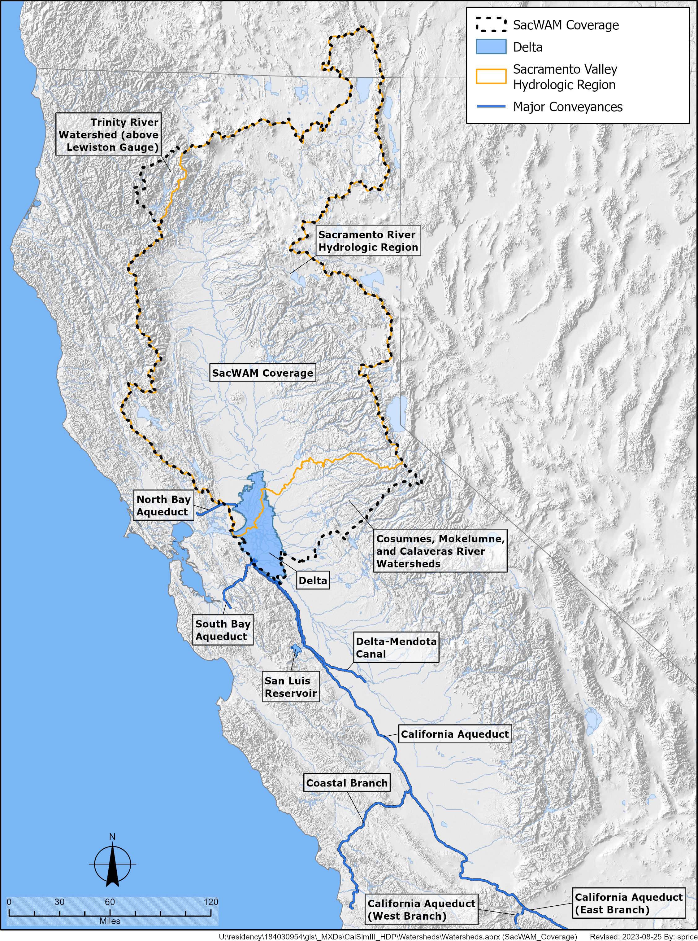
Click on Map to Enlarge
SacWAM Domain
Example SacWAM Representation
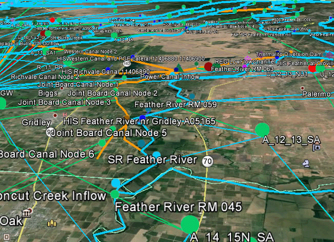
Click on Map to Enlarge
Example SacWAM Representation
