
Supply and Demand Assessment (SDA) – Putah Creek
Overview
The Putah Creek watershed lies within California’s Coast Ranges, draining roughly 600 square miles across Lake and Napa counties before reaching Lake Berryessa—one of the largest reservoirs in the state. Originating at springs on the eastern side of Cobb Mountain, the creek descends steeply through rugged terrain formed by complex geology, including volcanic rock and serpentine soils. This upstream portion of the watershed is characterized by oak woodlands, chaparral, and steep canyons, and plays a critical role in capturing runoff that feeds Lake Berryessa, which in turn supports the Solano Project and regional water supply. Downstream of Monticello Dam, Putah Creek continues through Yolo and Solano counties, transitioning from a regulated flow corridor into an ecologically significant riparian system that supports wildlife habitat, agriculture, and recreation before ultimately reaching the Yolo Bypass and the Sacramento River. Seasonal flows are heavily influenced by both natural precipitation and regulated releases from Monticello Dam, and land use across the watershed includes rangeland, recreation, and scattered rural development.
Hydrologic conditions in Putah Creek have been significantly altered by the Solano Project, especially the construction of Monticello Dam, which has changed the timing and volume of flows downstream. Although the dam provides important water supply and flood control benefits, it has also contributed to ecological challenges, including the disconnection of historic floodplains, reduction in instream gravel for spawning, and suppression of natural flow variability. Despite these impacts, the watershed continues to support cold freshwater habitat and remnant populations of native fish species, such as rainbow trout. Regional partners, including the Upper Putah Creek Stewardship and other local groups, are actively engaged in habitat restoration, invasive species management, and community-based monitoring efforts to improve conditions in the watershed and enhance long-term resilience.
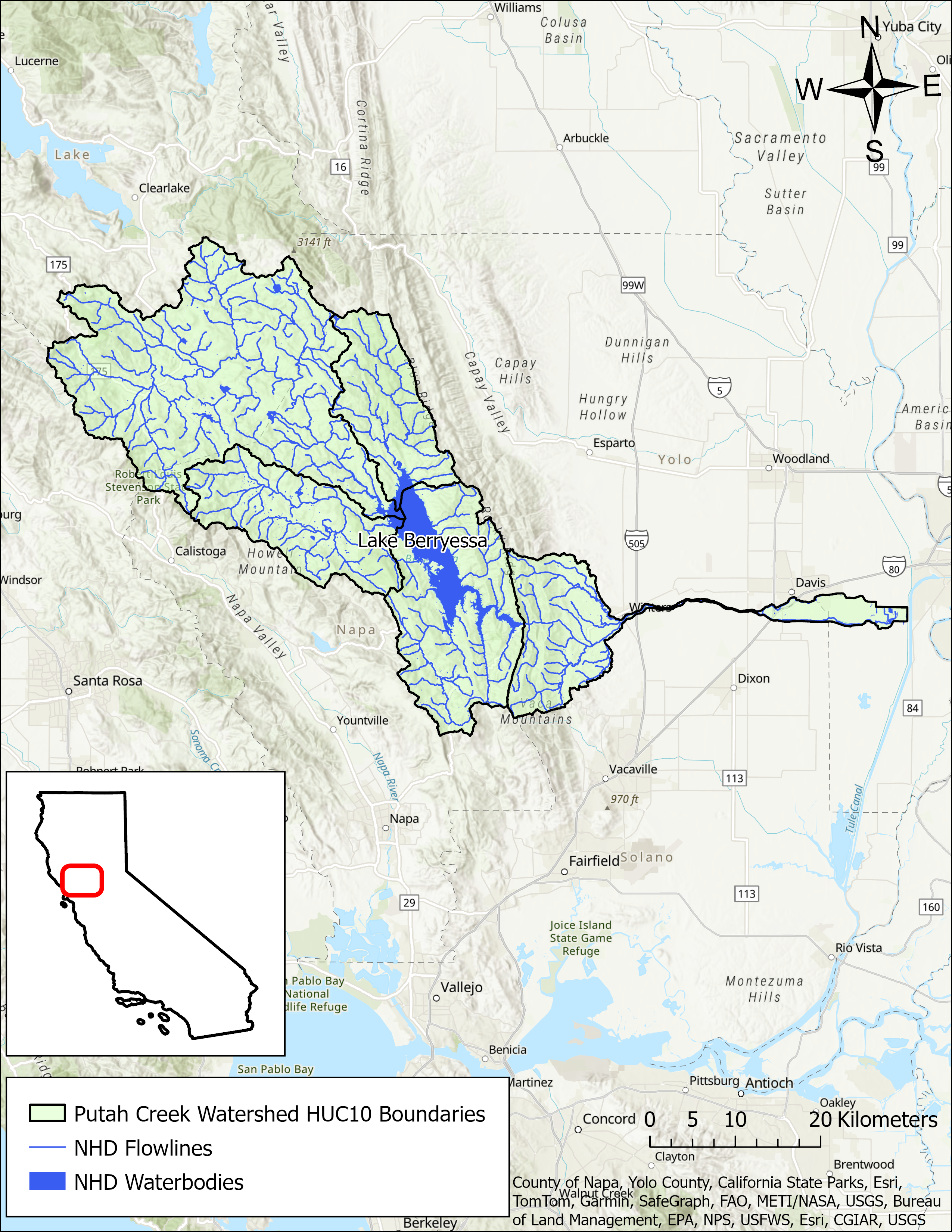
- Click on Map to Enlarge
Announcements
May 26, 2026 - DRAFT Putah Creek Model Development Report - Now Available
The model development report from Paradigm Environmental for the Putah Creek water supply model is now publicly available in Model Development section below. Please email questions regarding the model development to DWR-SDA@waterboards.ca.gov.
Outreach and Engagement
Modeling in the Putah Creek Watershed
The SDA Unit has continued to work on the models and tools developed for the Russian River Watershed during the State Water Board's 2021-2022 Regional Drought Response. These tools provided the necessary information for the Division of Water Rights (Division) to assess water availability and issue water right curtailments to ensure adequate, minimal water supplies for critical purposes under the emergency regulation.
To capture the water demand in the SDA Program Watersheds, water right demand estimates were incorporated based on information from annual reports of water diversion and use submitted to the Division. The SDA Unit continued to develop the Division’s demand dataset methodology and converted it into a series of R scripts and manual review spreadsheets that apply data quality correction flags. For example, the scripts identified and corrected unit conversion errors, duplicate reporting, and misplotted points of diversion. The SDA Unit then uses a water allocation tool adopted from the UC Davis Drought Water Rights Allocation Tool (DWRAT) to allocate available supply amongst water right holders based on their respective water right priority and water demands. This version of DWRAT allocates water at the subbasin level and accounts for imported flows.
The SDA Unit’s demand methodology, along with the supply scripts and the watershed specific versions of DWRAT, will be made available on the California Water Board Data Center GitHub page as separate repositories.
Additional Resources
Supply and Demand Assessment Program Links
Supply and Demand Assessment Information
Project Watersheds:
Stay Informed
Email Subscription List
Subscribe to the SDA Information email topic to receive notifications and the latest updates.
Contact Us
If you have questions or please email them to: DWR-SDA@waterboards.ca.gov
